
Newark is the most populous city in the U.S. state of New Jersey and the seat of Essex County and part of the New York metropolitan area. As one of the nation's major air, shipping, and rail hubs, the city had a population of 311,549 in 2020, making it the nation's 62nd-most populous municipality, after being ranked 73rd in the nation in 2010.
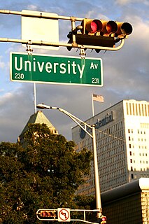
University Heights is a neighborhood in Newark in Essex County, New Jersey, United States. It is named because of the location of four academic institutions within its boundaries — Rutgers University, the New Jersey Institute of Technology (NJIT), the New Jersey Medical School (Rutgers), and Essex County College. In total, the schools enroll approximately 35,000 degree-seeking students.

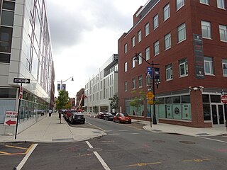
Broadway is an neighborhood within the city of Newark in Essex County, New Jersey, United States. It is located on the west bank of the Passaic River, in Newark's North Ward, east of Forest Hill and north of Seventh Avenue. The neighborhood extends from Interstate 280 to Belleville. The term "Broadway" has only come into use recently, most Broadway residents simply refer to their area as part of the North Ward. The street itself "Broadway" was called "Washington Avenue" until the early twentieth century. Today, the area is predominantly Italian American, Puerto Rican and Dominican, with a growing population from other parts of Latin America. The New Jersey Historical Society was located here from the 1930s to 1997. The neo-classical Mutual Benefit building was constructed in the Broadway neighborhood in 1927. The district has many old brownstones in various states of repair. There are high-rise apartment buildings overlooking Branch Brook Park.

Roseville is a neighborhood in the city of Newark in Essex County, New Jersey, United States. It borders Bloomfield and East Orange. To the neighborhood's immediate east is the Newark City Subway and Branch Brook Park. Roseville is divided into Upper Roseville north of 3rd Ave and Lower Roseville south of 3rd Ave.

Clinton Hill is a neighborhood within the south-central portion of the city of Newark in Essex County, New Jersey, United States. It is centered at Clinton Avenue, and bounded roughly by Elizabeth Avenue in the east, Hawthorne Avenue in the south, Avon Avenue in the north, and Irvington in the west.

Strawberry Mansion is a neighborhood in the U.S. city of Philadelphia, Pennsylvania, located east of Fairmount Park in North Philadelphia. The neighborhood is bounded by 33rd Street to the west, 29th Street to the east, Lehigh Avenue to the north, and Oxford Street to the south. As of the 2000 census, the neighborhood had a population of 22,562. It is often associated with the historic house of the same name, Historic Strawberry Mansion, located adjacent to the neighborhood and generally thought to be the source of the community's name.

Ivy Hill is a neighborhood of Newark, Essex County, New Jersey, United States. It is a diverse neighborhood in the city's West Ward bordering South Orange, Maplewood and Irvington.There are many well kept homes and streets in the neighborhood. The Ivy Hill neighborhood is often considered a section of the Vailsburg area.

Greenville is the southernmost section of Jersey City in Hudson County, New Jersey, United States.
India Square, also known as "Little India," is a commercial and restaurant district in the Journal Square and Marion Section neighborhoods of Jersey City, New Jersey. The area is home to the highest concentration of Indian Americans in the Western Hemisphere, and is a rapidly growing Indian New Yorker ethnic enclave within the New York Metropolitan Area. The neighborhood is centered on Newark Avenue, between Tonnele Avenue and JFK Boulevard, and is considered to be part of the larger Journal Square District. This area has been home to the largest outdoor Navratri festivities in New Jersey as well as several Hindu temples. This portion of Newark Avenue is lined with grocery stores including Patel Brothers and Subzi Mandi Cash & Carry, electronics vendors, video stores, clothing stores, and restaurants, and is one of the busiest pedestrian areas of this part of the city, often stopping traffic for hours. According to the 2000 census, there were nearly 13,000 Indians living in this two-block stretch in Jersey City, up from 3,000 in 1980, increasing commensurately between 2000 and 2010. As of the 2010 Census, over 27,000 Asian Indians accounted for 10.9% of Jersey City's population, the highest proportion of any major U.S. city.

The Heights or Jersey City Heights is a district in the north end of Jersey City, New Jersey, atop the New Jersey Palisades overlooking Hoboken to the east and Croxton in the Meadowlands to the west.

Five Corners is a neighborhood located at the intersection of Summit Avenue, Newark Avenue, and Hoboken Avenue in Jersey City, New Jersey, United States, and is situated in the northeastern portion of the larger Journal Square district. The name of the intersection is used for the neighborhood radiating from the crossing, which is adjacent to the Hilltop, just south of Bergen Arches and The Divided Highway.
The West Side is a neighborhood in the city of Newark in Essex County, New Jersey, United States. It is bounded on the east by Bergen Street, on the south by Rose Terrace and Avon Avenue, on the west by Irvington and on the north by South Orange Avenue. The main roads running through the neighborhood are Bergen Street, South Orange Avenue and Springfield Avenue. The mostly residential neighborhood is home to Woodland Cemetery and West Side Park. West Side High School and Chad Science Academy (7-12) are also in this neighborhood. The area between 14th Street, 17th Avenue, 12th Avenue and Avon Avenue, once called Wolf's Harbor, is now the area around West Side Park. The area of Wolf's Harbor was once a large marsh that was home to several wolves. The area was renamed Magnolia Swamp after the tree when the wolves disappeared from the swamp. The swamp was filled in over time and eventually 14th Street cut through the middle of it after land was repeatedly filled in by Edward Keogh. West Side Park, a county run park, was originally situated on a hill full of linden trees overlooking a lake, but the lake was later filled in to accommodate fields. Today the west side of the park remains elevated over the clear flat east side of the park and the hill was once used for skiing. There were once performances at the park, including Dionne Warwick and Whitney Houston.
Prince Street Synagogue, in the Springfield/Belmont neighborhood, is the oldest synagogue building still standing in Newark, Essex County, New Jersey, United States.
The Village is a neighborhood in the western section of Historic Downtown in Jersey City. It is bordered by Hamilton Park and Harsimus Cove to the east and the Turnpike Extension to the west, on the other side of which Jones Park and Mary Benson Park are located. Newark Avenue is the major street across the Village from Grove Street at the east to Bergen Hill at the west. The neighborhood for many years was considered the city's "Little Italy" neighborhood. Brunswick Street, between 1st and 10th Streets was once full of merchants and nicknamed "Bushel Avenue". St. Anthony of Padua Roman Catholic Church at 457 Monmouth St. received its historic designation on March 22, 2004.

The Four Corners Historic District is the intersection of Broad and Market streets in Newark, New Jersey. It is the site of the city's earliest settlement and the heart of Downtown Newark that at one time was considered the busiest intersection in the United States. The area that radiates 22 square blocks from the crossroads is a state and federal historic district.

Weequahic is a neighborhood in the city of Newark in Essex County, New Jersey, United States. Part of the South Ward, it is separated from Clinton Hill by Hawthorne Avenue on the north, and bordered by the township of Irvington on the west, Newark Liberty International Airport and Dayton on the east, and Hillside Township and the city of Elizabeth on the south. There are many well maintained homes and streets. Part of the Weequahic neighborhood has been designated a historic district; major streets are Lyons Avenue, Bergen Street, and Chancellor Avenue.

Vailsburg is a neighborhood in the city of Newark in Essex County, New Jersey, United States. Part of the West Ward, its elevation is 280 feet (85 m). As of 2000, Vailsburg had a population of 34,348. The Vailsburg section of Newark is on a hill which closely aligns with the suburban and park areas outside it. Vailsburg includes the two smaller neighborhoods of upper Vailsburg and lower Vailsburg, both of which have Sanford Avenue as a focal point. Upper Vailsburg is closer to Maplewood and South Orange.
The following is a timeline of the history of the city of Newark, New Jersey, United States.
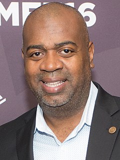
The 2014 Newark mayoral election took place in Newark, the most populous city in New Jersey, on May 13, 2014. The race was characterized as a contest between two candidates, Ras Baraka and Shavar Jeffries, both from Newark's South Ward. Elections for all seats on the nine member Municipal Council of Newark also took place. Luis A. Quintana, who had become Mayor of Newark following the resignation of Cory Booker, did not seek the seat.
Teachers Village is a neighborhood centered around Halsey Street in Newark, New Jersey. It is located in Downtown Newark in southwest quadrant of the Four Corners Historic District, south of Market Street (SoMa) in the Central Ward between the Prudential Center and Springfield/Belmont.

