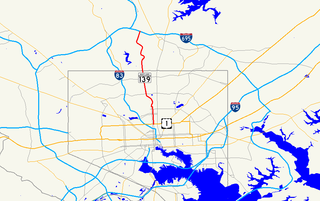
St. Charles Parkway is an unnumbered county road in Charles County. It begins at the intersection where MD 5 branches off northwards on Mattawoman Beantown Road and MD 5 BUS (Leonardtown Road) continues westward until its terminus at US Route 301. It primarily serves as the main road into the various villages and neighborhoods of St. Charles. In 2008, the parkway was extended farther south to connect with the town of La Plata at the intersection of Rosewick Road and Radio Station Road. [1] This offers through traffic another route around the often-congested US 301 in Waldorf.
Charles County is a county located in the southern central portion of the U.S. state of Maryland. As of the 2010 census, the population was 146,551. The county seat is La Plata. The county was named for Charles Calvert (1637–1715), third Baron Baltimore.

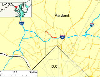
Maryland Route 5 is a 74.34-mile (119.64 km) long state highway that runs north–south in the U.S. state of Maryland. The highway runs from Point Lookout in St. Mary's County north to the Washington, D.C. border in Suitland, Prince George's County. MD 5 begins as the two-lane undivided Point Lookout Road which runs from Point Lookout, St. Mary's County, to an intersection with MD 235 in the northern part of the county. Point Lookout Road passes through rural areas as well as the county seat of Leonardtown. After the MD 235 intersection, the route becomes the four-lane divided Three Notch Road and continues into Charles County, where it becomes Leonardtown Road. Here, the route bypasses Hughesville and continues north toward the Waldorf area, which it bypasses to the east on Mattawoman Beantown Road. The route merges onto U.S. Route 301 and enters Prince George's County, splitting from US 301 at an interchange in Brandywine. From here, MD 5 continues north on Branch Avenue, running through suburban areas, before becoming a freeway as it passes Andrews Air Force Base and interchanges with Interstate 95 (I-95)/I-495. Past the Capital Beltway, the route runs through suburban areas of Hillcrest Heights and Suitland before reaching the D.C. border, where Branch Avenue continues, crossing Pennsylvania Avenue and eventually terminating at Randle Circle.

U.S. Route 301 (US 301) is a spur of U.S. Route 1 running through the South Atlantic States. It currently runs 1,099 miles (1,769 km) from Biddles Corner, Delaware at Delaware Route 1 to Sarasota, Florida at U.S. Route 41. It passes through the states of Delaware, Maryland, Virginia, North Carolina, South Carolina, Georgia, and Florida. It goes through the cities of Annapolis, Maryland; Richmond and Petersburg, Virginia; Rocky Mount, Wilson, and Fayetteville, North Carolina; Florence, South Carolina; Statesboro and Jesup, Georgia; and Ocala, Zephyrhills, Brandon, and Sarasota, Florida.
St. Charles Parkway serves the following neighborhoods:
- Sentry Woods (part of Huntington Neighborhood/Smallwood Village) via St. Marks Drive
- Wakefield Neighborhood (part of Smallwood Village) via St. Thomas Drive
- Huntington Neighborhood (part of Smallwood Village) via Post Office Road
- Bannister Neighborhood (part of Smallwood Village) via St. Ignatius Drive
- Sheffield Neighborhood (part of Fairway Village) via St. Andrews Drive
- Carrington Neighborhood (part of Smallwood Village) via Dartmouth Road, Cambridge Drive, Duncannon Road, and Kintore Road
- Heritage Active Adult Community (part of Fairway Village) via Demarr Road
According to the St. Charles Master Plan, [2] [3] future neighborhoods and villages that will be served by the Parkway include:
- Gleneagles Neighborhood (will be part of Fairway Village)
- Wooded Glen Village
- Piney Reach Village
White Plains Regional Park, which includes an 18-hole golf course, lighted tennis courts, picnic pavilions, and a playground, is located off of St. Charles Parkway. Also nearby is Regency Furniture Stadium (via Billingsley Road), home of the Southern Maryland Blue Crabs.

Regency Furniture Stadium is a 4,200-seat baseball park in Waldorf, Maryland that hosted its first regular season baseball game on May 2, 2008, as the tenants of the facility, the Southern Maryland Blue Crabs defeated the Lancaster Barnstormers, 3-2. For the 2010 baseball season, the collegiate summer Southern Maryland Nationals of the Cal Ripken, Sr. Collegiate Baseball League will play select games at the venue. The CRSCBL previously used Regency Furniture for the Mid-Atlantic Classic. With the groundbreaking for Southern Maryland's new stadium, a local company, Regency Furniture, purchased the naming rights for $2.88 million over 10 years.

The Southern Maryland Blue Crabs are an American professional baseball team based in Waldorf, Maryland. They are members of the Freedom Division of the Atlantic League of Professional Baseball, an independent baseball league which is not affiliated with Major League Baseball. Since 2008, the Blue Crabs have played their home games at Regency Furniture Stadium. They represent the counties of Charles, Calvert, and St. Mary's, which are located on the Southern Maryland peninsula between Chesapeake Bay and the Potomac River.

Algonquin is a village in McHenry and Kane counties, Illinois, in the United States. It is a suburb of Chicago, located approximately 40 miles (64 km) northwest of the Loop. As of the 2010 census the village's population was 30,046, and as of 2017 the estimated population was 31,017.

St. Charles is a planned community in Charles County, Maryland, United States. It is 22 miles (35 km) south-southeast of Washington, D.C., 24 miles (39 km) from northern Virginia and immediately south of Waldorf, which is the mailing address.. At the 2000 census, it was delineated as a census-designated place (CDP), with a population of 33,379. It was included in the Waldorf CDP for the 2010 census.

Waldorf is an unincorporated community and census-designated place in Charles County, Maryland, United States. It is 23 miles (37 km) south-southeast of Washington, D.C. The population of the census-designated area was 67,752 at the 2010 census. Waldorf was settled before 1900 as a rural crossroads with a train station and was called "Beantown" after a local family.

Maryland Route 18 (MD 18) is a state highway in the U.S. state of Maryland. The state highway runs 20.37 miles (32.78 km) from the beginning of state maintenance at Love Point east to MD 213 in Centreville. MD 18 is the main east–west local highway on Kent Island and east to Centreville, serving the centers of Stevensville, Chester, Kent Narrows, Grasonville, and Queenstown that are bypassed by U.S. Route 50 (US 50) and US 301. What is signed as MD 18 is actually a set of four suffixed highways: MD 18A, MD 18B, MD 18S, and MD 18C. There are also several unsigned segments of MD 18 scattered along the length of the signed portions.

Maryland Route 3, part of the Robert Crain Highway, is the designation given to the former alignment of U.S. Route 301 from Bowie, Maryland, USA, to Baltimore. It is named for Robert Crain of Baltimore. It is unique in Maryland in that it has a business route and a truck route which do not connect to their parent; however, the business route is also a part of the Robert Crain Highway. MD 3's current orientation is vestigial from the construction of Maryland's freeway system.

U.S. Route 50 is a major east–west route of the U.S. Highway system, stretching just over 3,000 miles (4,800 km) from Ocean City, Maryland on the Atlantic Ocean to West Sacramento, California. In the U.S. state of Maryland, US 50 exists in two sections. The longer of these serves as a major route connecting Washington, D.C. with Ocean City; the latter is the eastern terminus of the highway. The other section passes through the southern end of Garrett County for less than 10 miles (16 km) as part of the Northwestern Turnpike, entering West Virginia at both ends. One notable section of US 50 is the dual-span Chesapeake Bay Bridge across the Chesapeake Bay, which links the Baltimore–Washington metropolitan area with the Eastern Shore region, allowing motorists to reach Ocean City and the Delaware Beaches.

Maryland Route 228 (MD 228) is a state highway in the U.S. state of Maryland. Known as Berry Road, the state highway runs 6.88 miles (11.07 km) from MD 210 in Accokeek east to U.S. Route 301 (US 301) and MD 5 Business in Waldorf. MD 228, which is a four-lane divided highway for its entire length, is a major commuter route between southwestern Prince George's County and northern Charles County. In conjunction with MD 210, the state highway serves as an alternative to US 301 and MD 5 as a route to Washington, D.C. from Southern Maryland. MD 228 also serves as part of the connection, again via MD 210, between Waldorf and Indian Head Naval Surface Warfare Center.
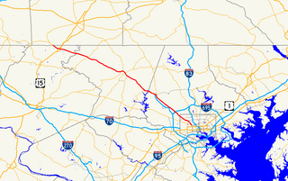
Charles Street, known for most of its route as Maryland Route 139, runs through Baltimore City and through the Towson area of Baltimore County. On the north end it terminates at an intersection with Bellona Avenue near Interstate 695 and at the south end it terminates in Federal Hill in Baltimore. Charles Street is one of the major routes through the city of Baltimore, and is a major public transportation corridor. For the one-way portions of Charles Street, the street is functionally complemented by the parallel St. Paul Street, Maryland Avenue, Cathedral Street, and Liberty Street.
U.S. Route 301 (US 301) in the state of Maryland is a major highway that runs from Delaware to the Governor Harry W. Nice Memorial Bridge into Virginia. It passes through three of Maryland's four main regions: the Eastern Shore, the Baltimore-Washington Metropolitan Area, and Southern Maryland. US 301 serves mainly as a bypass of Baltimore and Washington from Delaware to Virginia.
Maryland Route 140 is a 49-mile (79 km) state highway in the U.S. state of Maryland.

Country Club Gardens is a residential neighborhood in Planning District Five (D5) of New Orleans, Louisiana, in the United States comprising homes along six streets:

Maryland Route 129 is a state highway in the U.S. state of Maryland, running north-northwesterly from Baltimore into Baltimore County, ending east of Reisterstown. The route leaves downtown on the one-way pair of McCulloh Street and Druid Hill Avenue, and then uses the entire length of Park Heights Avenue to the end. MD 129 connects Downtown Baltimore with Druid Hill Park using McCulloh Street and Druid Hill Avenue. As Park Heights Avenue, the state highway is one of two primary radial routes in the northwestern part of the city, providing access to The Maryland Zoo and Pimlico Race Course. In Baltimore County, MD 129 passes through Pikesville, where it has a junction with Interstate 695 (I-695) and serves an affluent rural area north of Pikesville and east of Reisterstown.
Northern Parkway is a major road that runs west–east across the northern part of the city Baltimore. For most of the way, it is at least six lanes wide, and it is used by motorists for crosstown travel. It is designated E. Northern Pkwy and W. Northern Pkwy with Charles Street being the dividing line. It was constructed in the 1950s through several neighborhoods and several homes were razed in the process from right-of-way. The section of E. Northern Pkwy from Harford Road to Fleetwood Ave was originally called German Lane.

Maryland Route 322 (MD 322) is a state highway in the U.S. state of Maryland. Known as Easton Parkway, the highway runs 5.12 miles (8.24 km) on the west side of Easton between two junctions with U.S. Route 50 (US 50). MD 322 serves as a bypass of downtown Easton for traffic between US 50 and highways to western Talbot County, including MD 33 toward Saint Michaels and MD 333 toward Oxford. Easton Parkway was constructed in the mid to late 1960s. The state highway was originally designated as part of MD 33; MD 322 became the sole designation on the bypass in 1978.

Gun Hill Road is a major thoroughfare in the New York City borough of the Bronx. The road stretches for 3.5 miles (5.6 km) from the Mosholu Parkway in Norwood to Stillwell Avenue in Baychester, near an exit for the Hutchinson River Parkway. Van Cortlandt Park and the Mosholu Golf Course are both located at the western terminus of Gun Hill Road.

Maryland Route 925 is a state highway in the U.S. state of Maryland. Known as Old Washington Road, the state highway runs 2.49 miles (4.01 km) from Billingsley Road in White Plains north to MD 5 Business in Waldorf. MD 925 and the county-maintained portion of Old Washington Road to the north comprise the old alignment of U.S. Route 301 in northern Charles County. Originally constructed as part of MD 3 and MD 5 in the early 1910s, the highway become part of US 301 in the early 1940s, then was bypassed by the present US 301 divided highway in the mid-1950s. The White Plains–Waldorf portion of the old road was renumbered MD 925 in the early 1960s.
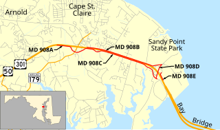
Maryland Route 908 is a collection of unsigned state highways in the U.S. state of Maryland. These five highways are service roads that parallel and provide access to U.S. Route 50 and US 301 along their western approach to the Chesapeake Bay Bridge; the highways also provide access to Sandy Point State Park. The first modern highway from Cape St. Claire to Skidmore was constructed in the late 1920s and replaced by the modern alignment of US 50 in the late 1940s. The frontage roads on either side of the U.S. Highway were constructed in the early 1950s. The mainline segments of MD 908 assumed their present form when US 50 and US 301 were upgraded to a freeway in the early 1990s.

Maryland Route 191 is a state highway in the U.S. state of Maryland. Known for most of its length as Bradley Boulevard, the highway runs 7.16 miles (11.52 km) from MD 190 in Potomac east to MD 185 in Chevy Chase. MD 191 serves an affluent area with many golf courses as it connects Potomac and Chevy Chase by way of an S-shaped path through Bethesda in southwestern Montgomery County. Bradley Lane, the name for the Chevy Chase portion of the highway, was paved by 1910. This included the segment of the lane between MD 185 and MD 186, which was removed from the state highway in the 1940s. The remainder of MD 191 was constructed along mostly new alignment through Bethesda and Potomac in the early 1920s. The highway originally continued beyond its present western terminus and looped south along Persimmon Tree Road to Cabin John. MD 191 was expanded to a divided highway between what is now MD 355 and MD 614 in two portions in the 1940s and 1960s. The highway was relocated at its Persimmon Tree Road crossing of Interstate 495 (I-495) when the freeway was built in the early 1960s. The Cabin John–Potomac portion of MD 191 was removed from the state highway system in 1999.
Maryland Route 192 is a state highway in the U.S. state of Maryland. The highway runs 2.53 miles (4.07 km) from Summit Avenue in Kensington east to MD 97 in Forest Glen. MD 192 connects MD 185 with the Kensington station on MARC's Brunswick Line and MD 97 and Interstate 495 (I-495) with the Forest Glen station on the Washington Metro's Red Line. The highway was constructed from Forest Glen to Kensington in the mid-1920s. MD 192 also included three sections between MD 97 and U.S. Route 29 in Four Corners built in the mid-1930s. The final segment east of MD 97 was removed from the state highway system in the late 1980s.