
County Mayo is a county in Ireland. In the West of Ireland, in the province of Connacht, it is named after the village of Mayo, now generally known as Mayo Abbey. Mayo County Council is the local authority. The population was 137,231 at the 2022 census. The boundaries of the county, which was formed in 1585, reflect the Mac William Íochtar lordship at that time.

Belmullet is a coastal Gaeltacht town with a population of 1,019 on the Mullet Peninsula in the barony of Erris, County Mayo, Ireland. It is the commercial and cultural heart of the barony of Erris, which has a population of almost 10,000. According to the 2016 census 50% of people in the town were able to speak Irish while only 4% spoke it on a daily basis outside the education system.

Aughagower or Aghagower is a small village in rural County Mayo in western Ireland. It is located about 6 km from Westport. Aughagower has around 40 houses, 1 pub and a shop, with a clear view of Croagh Patrick from Reek View. It also forms the centre of a parish of the same name which covers an area of 86.1 square miles. The village is known for its links to Saint Patrick and Tóchar Phádraig, the pilgrimage route from Ballintubber Abbey to Croagh Patrick.

An Eachléim, anglicized as Aughleam or Aghleam, is a Gaeltacht village and townland in County Mayo, Ireland. It lies on the Mullet Peninsula in Erris, on the R313 regional road. It has a total area of 2.96 km2 (1.14 sq mi). Its name derives from Irish Each (horse) and Léim (leap), as local folklore has it a horse leapt from the east of the townland to the west, marking out its borders.
Bangor Erris is a town in Kiltane parish in Erris, County Mayo, Ireland with a population of over 300. It is on the banks of the Owenmore River and is a "gateway" to the Erris Peninsula linking Belmullet with Ballina and Westport. It is located at the foot of the "Bangor Trail" a 22-mile mountain pass across the Nephin Beg Mountain Range to Newport. Approximately 2 km away is Carrowmore Lake, Bangor is a centre for wild atlantic salmon and sea trout fishing. Bangor Erris is located in the Parish of Kiltane. Due west from Bangor are the towns of Belmullet, Geesala, Mulranny, Westport and Doolough.

Erris is a barony in northwestern County Mayo in Ireland consisting of over 230,452 acres (932.61 km2), much of which is mountainous blanket bog. It has extensive sea coasts along its west and north boundaries. The main towns are Belmullet and Bangor Erris. The name Erris derives from the Irish 'Iar Ros' meaning 'western promontory'. The full name is the Iorrais Domnann, after the Fir Bolg tribe, the Fir Domnann. To its north is the wild Atlantic Ocean and the bays of Broadhaven and Sruth Fada Conn and to its west is Blacksod Bay. Its main promontories are the Doohoma Peninsula, Mullet Peninsula, Erris Head, the Dún Chiortáin and Dún Chaocháin peninsulas and Benwee Head.

The Mullet Peninsula —also known as the Mullet and sometimes as the Erris Peninsula—is a peninsula in the barony of Erris in County Mayo, Ireland. As of 2016 it has a population of 3963. It consists of a large promontory connected to the mainland at Belmullet, a town of about 1,000 inhabitants, by a narrow isthmus. There are several villages on the Mullet peninsula including Aughleam, Elly, Corclough and Binghamstown. The Peninsula is about 33 km (21 mi) long and ranges from 200 metres (660 ft) to 12 km (7.5 mi) wide. Its northernmost point is Erris Head. The peninsula's doglegged shape forms two bays, Blacksod Bay and Broadhaven Bay.

Binghamstown is a townland and village in County Mayo, Ireland. It lies on the R313 regional road on the Mullet Peninsula, near the town of Belmullet. The townland of Binghamstown has an area of approximately 3 square kilometres (1 sq mi), and had a population of 106 people as of the 2011 census. Binghamstown is in the electoral division of An Geata Mór Thuaidh.
Glencastle is a small village in the northwest of County Mayo, Ireland. The townland incorporates an area of 2,336 acres (9.45 km2).

Blacksod Bay is a bay of the Atlantic Ocean in Erris, north County Mayo, Ireland. The 16 km (9.9 mi) long and 8 km (5.0 mi) wide bay is bounded on its western side by the Mullet Peninsula. Its eastern side includes Kiltane Parish, which extends southwards from Belmullet towards Gweesalia and Doohoma.
The civil parish of Kilcommon in Erris, northern County Mayo, Ireland has a total of 37 townlands: small geographic divisions of land in Ireland and Scotland's Outer Hebrides. Townlands originated in Gaelic Ireland, and predate the late-12th-century Anglo-Norman invasion. However, some townland names are derived from British plantations and Norman manors.

Clondalkin Round Tower is an Irish round tower or cloigtheach founded by Saint Mochua, also known as Saint Cronan, and located in Clondalkin, South Dublin, Ireland. It is now a National Monument in Ireland. It's also become a museum that houses a café.
Inchcleraun, also called Quaker Island, is an island situated in Lough Ree on the River Shannon, in central Ireland.
Aghowle Church is a medieval church and national monument in County Wicklow, Ireland. It was one of the largest rural parish churches of its era. Aghowle is also a civil parish in the ancient barony of Shillelagh.

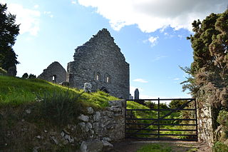
Inishmaine Abbey is a former Augustinian monastery and National Monument located in County Mayo, Ireland.
Templenagalliaghdoo is a medieval church and National Monument in County Mayo, Ireland.
St. Manchan's Oratory, also called An Teampall Geal is a medieval oratory and National Monument in County Kerry, Ireland.

Inchagoill is an island in Lough Corrib, Ireland. Its Christian ruins constitute an Irish National Monument. The island name means "Island of the devout foreigner."

Fallmore is a Gaeltacht village and townland in County Mayo, Ireland. Situated in the southern part of the Mullet Peninsula within the barony of Erris, Fallmore townland spans approximately 704 acres and, as of 2011, had a population of 75 people. Fallmore townland also encompasses the village of Blacksod.


