St Augustin's Church, Bournemouth

Last updated
St Augustin's Church in 2006. St Augustin's Church, Bournemouth - geograph.org.uk - 164914.jpg
St Augustin's Church in 2006.

St Augustin's Church is a Grade II listed Gothic Victorian Anglican church in Bournemouth, Dorset, England. The church stands across the A347 road from Wimborne Road Cemetery.

Contents

History

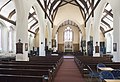
St. Augustin's church was constructed between 1891 and 1892 as a chapel of ease to St. Stephen's. [1] The church was designed by Gothic Revival architect William Butterfield. [2]

Related Research Articles

<span class="mw-page-title-main">Wimborne Minster</span> Town in Dorset, England

Wimborne Minster is a market town in Dorset in South West England, and the name of the Church of England church in that town. It lies at the confluence of the River Stour and the River Allen, 5 miles (8 km) north of Poole, on the Dorset Heaths, and is part of the South East Dorset conurbation. According to Office for National Statistics data the population of the Wimborne Minster built-up area as of 2014 was 15,552.

<span class="mw-page-title-main">East Dorset</span> Former non-metropolitan district in England

East Dorset was a local government district in Dorset, England. Its council met in Wimborne Minster between 2016 and 2019.

<span class="mw-page-title-main">Colehill</span> Parish in Dorset, England

Colehill is a parish neighbouring Wimborne Minster, in Dorset, England. It had a population of 7,000 in 2001, which shrunk slightly to 6,927 people at the 2011 census.

<span class="mw-page-title-main">Castleman Trailway</span> Footpath in Southern England

The Castleman Trailway is a footpath in Southern England. Portions of the trailway are also used as a cyclepath but the middle section from East Wimborne to the River Allen bridge is not cyclable.

<span class="mw-page-title-main">South East Dorset conurbation</span> Population centre in Southern England

The South East Dorset conurbation is a multi-centred conurbation on the south coast of Dorset in England.

<span class="mw-page-title-main">Oakdale, Dorset</span>

Oakdale is a suburb of Poole in Dorset, England with a population of 10,949, increasing to 11,554 at the 2011 Census and shares boundaries with Creekmoor, Poole Town, Parkstone, Newtown and Canford Heath

<span class="mw-page-title-main">Bearwood, Dorset</span>

Bearwood is a suburb of Poole, Dorset, England.

<span class="mw-page-title-main">Wimborne railway station</span> Disused railway station in Dorset, England

Wimborne was a railway station in Wimborne Minster in the county of Dorset in England. Open from 1 June 1847 to 2 May 1977, it was sited just north of the River Stour in what is still Station Road. Built for the Southampton and Dorchester Railway, the station was operated from the start by the London and South Western Railway, which took over ownership in 1848. It was then operated by the Southern Railway (1923–47) and from 1948 by the Southern Region of British Railways which traded as British Rail from 1965.

<span class="mw-page-title-main">Holmsley railway station</span> Disused railway station in Hampshire, England

Holmsley is a closed railway station in the county of Hampshire which served rural settlements in the New Forest.

Uplands School was a co-educational independent school based in the coastal town of Poole, Dorset on the south coast of England. It consisted of a junior school and a senior school. In 2009, the school merged with Wentworth College.

<span class="mw-page-title-main">Wimborne Road Cemetery, Bournemouth</span> Historic cemetery in Dorset, England

The Wimborne Road Cemetery is located at Wimborne Road, Bournemouth. It is grade II listed with Historic England. The cemetery was opened in 1878 and laid out by the architect Christopher Crabb Creeke. St Augustin's Church stands across the road from the cemetery.

<span class="mw-page-title-main">Northbourne, Bournemouth</span>

Northbourne is a suburb of Bournemouth, Dorset in England. It is in the north of the town and borders Ensbury Park.

There are many Grade II listed buildings in the county of Dorset. This is a list of them.

<span class="mw-page-title-main">Wimborne Market</span> Historic market in Wimborne Minster, Dorset, England

Wimborne Market was an historic market in a large covered structure in Wimborne Minster, Dorset, England. It ceased to trade on 19 December 2021 after 165 years of trading. The market was demolished and the land redeveloped.

<span class="mw-page-title-main">St Swithun's Church, Bournemouth</span> Church in Dorset, England

St Swithun's Church is a Grade II listed church in the town of Bournemouth, England.

<span class="mw-page-title-main">St. Andrew's Church, Richmond Hill</span>

St. Andrew's Church is a Grade II listed Gothic Victorian church in Richmond Hill, Bournemouth, Dorset, England. A United Reformed church, it is noted for being the largest church in the town.

<span class="mw-page-title-main">St Michael's Church, Bournemouth</span>

St Michael's Church is a Grade II* listed Gothic Victorian church in Bournemouth, Dorset, England.

<span class="mw-page-title-main">St Alban's Church, Bournemouth</span> Church in Bournemouth, UK

St Alban's Church is a Grade II listed Gothic Revival Anglican church in the Charminster area of Bournemouth, Dorset, England. The church stands across Charminster Road from the Church of the Annunciation.

<span class="mw-page-title-main">Church of the Annunciation, Bournemouth</span> Church in Bournemouth, UK

The Church of the Annunciation is a Grade II* listed Gothic Revival Catholic church in the Charminster area of Bournemouth, Dorset, England. The church stands across Charminster Road from St Alban's Church.

<span class="mw-page-title-main">Gulliver's Tavern</span> Pub in Bournemouth, Dorset, England

Gulliver’s Tavern, formerly known as the Dolphin Inn, is a historic pub in the Kinson area of Bournemouth, Dorset, England. It is believed to be the oldest pub in the town.

References

  1. "The parish church of St. Augustin, Bournemouth, Hampshire". ukga.org. Retrieved 2022-11-25.
  2. Stuff, Good. "Church of St Augustin, Central, Bournemouth, Christchurch and Poole". britishlistedbuildings.co.uk. Retrieved 2022-11-25.

See also

50°43′54″N1°52′30″W / 50.731603°N 1.875046°W / 50.731603; -1.875046