St George's Road

Last updated

St George's Cathedral from St George's Road. St George's Cathedral Southwark.JPG
St George's Cathedral from St George's Road.
St George's Cathedral main entrance, on the corner of Lambeth Road and St George's Road. St georges roman catholic cathedral southwark.jpg
St George's Cathedral main entrance, on the corner of Lambeth Road and St George's Road.
Imperial War Museum off St George's Road. Imperial War Museum Front.JPG
Imperial War Museum off St George's Road.

St George's Road is a one-way road in Southwark, London running between Westminster Bridge Road to the northwest and Elephant and Castle to the southeast. The direction of the vehicular traffic is from Elephant and Castle to Westminster Bridge Road. Its name derives from its crossing of St George's Fields, being an open rural area of the parish of St George the Martyr, Southwark. The road was laid out as part of the communications improvements for Westminster Bridge, from the 1740s, connecting the Bridge to the Elephant and Castle junctions with New Kent Road, Walworth Road and Kennington Park Road (part of the Roman Stane Street).

The north end of St George's Road splits into two, with the left side merging into Westminster Bridge Road northbound, and the right side going around St George's Cathedral and joining Westminster Bridge Road southbound. A listed K2 red telephone box is located at this point. [1]

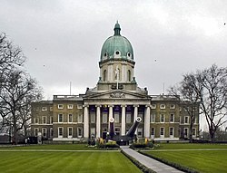
St George's Cathedral is on the north side and the Imperial War Museum and the surrounding Geraldine Mary Harmsworth Park is on the south side opposite, at the junction with Lambeth Road (A3203). On the west side at this junction is the former Royal South London Dispensary, listed under its subsequent name of the Elizabeth Baxter Hostel. [2] It is now the School of Historical Dress. [3] It was during the refurbishment of the building as the School of Historical Dress that the lettering for the Dispensary was revealed. The London College of Communication is at the Elephant and Castle end of the road.

The north end of St George's Road has a terrace of 21 Grade II listed buildings, which starts at the School of Historical Dress and goes up to the Morley College Gallery, part of Morley College. This terrace was originally known as Laurie Terrace, [4] with the Laurie Terrace lettering still visible above the central building, 125 St George's Road.

West Square, a typical historic and unspoilt London square, is to the south of St George's Road.

The engineer Joseph Clement died at 31 St George's Road on 28 February 1844; the genealogist and author Melville Henry Massue, Marquis de Ruvigny, died at 46 St George's Road on 6 October 1921.

The English builder and architect George Myers is commemorated by a blue plaque at his home in 131 St George's Road where he lived between 1842 and 1853. [5]

The headquarters of the 1st Surrey Volunteer Engineers, a company of volunteer firemen, was at Prospect Place, St George's Road from October 1861. [6]

Related Research Articles

<span class="mw-page-title-main">Blackfriars Bridge</span> Bridge over the River Thames in London

Blackfriars Bridge is a road and foot traffic bridge over the River Thames in London, between Waterloo Bridge and Blackfriars Railway Bridge, carrying the A201 road. The north end is in the City of London near the Inns of Court and Temple Church, along with Blackfriars station. The south end is in the London Borough of Southwark, near the Tate Modern art gallery and the Oxo Tower.

<span class="mw-page-title-main">London Borough of Southwark</span> Borough in United Kingdom

The London Borough of Southwark in South London forms part of Inner London and is connected by bridges across the River Thames to the City of London and London Borough of Tower Hamlets. It was created in 1965 when three smaller council areas amalgamated under the London Government Act 1963. All districts of the area are within the London postal district. It is governed by Southwark London Borough Council.

<span class="mw-page-title-main">Newington, London</span> Human settlement in England

Newington is a district of South London, just south of the River Thames, and part of the London Borough of Southwark. It was an ancient parish and the site of the early administration of the county of Surrey. It was the location of the County of London Sessions House from 1917, in a building now occupied by the Inner London Crown Court.

<span class="mw-page-title-main">Elephant and Castle</span> Area in London, England

Elephant and Castle is an area of South London, England, in the London Borough of Southwark. The name also informally refers to much of Walworth and Newington, due to the proximity of the London Underground station of the same name. The name is derived from a local coaching inn.

<span class="mw-page-title-main">New Kent Road</span> Road in Southwark, London, England

New Kent Road is a 1 kilometre (0.6 mi) road in the London Borough of Southwark. The road was created in 1751 when the Turnpike Trust upgraded a local footpath. This was done as part of the general road improvements associated with the creation of Westminster Bridge; in effect it was possible to travel from the West End/ Westminster to the south-east without having to go via the Borough of Southwark but could now cross St George's Fields to the junction of Newington Causeway and Newington Butts which is where New Kent Road starts at Elephant & Castle. The route runs eastward for a few hundred yards to the junction of Great Dover Street and Tower Bridge Road, known as Bricklayers Arms, where it joins the original route to the south-east Old Kent Road.

<span class="mw-page-title-main">Southwark Bridge</span> Grade II listed steel bridge in London Borough of Southwark, United kingdom

<span class="mw-page-title-main">Borough High Street</span>

Borough High Street is a road in Southwark, London, running south-west from London Bridge, forming part of the A3 route which runs from London to Portsmouth, on the south coast of England.

<span class="mw-page-title-main">Burgess Park</span> Park in Southwark, London

Burgess Park is a public park situated in Camberwell the London Borough of Southwark, and is close to Walworth to the north, Bermondsey to the east and Peckham to the south. At 56 hectares, it is one of the largest parks in South London.

<span class="mw-page-title-main">St George's Fields</span>

<span class="mw-page-title-main">St George's Circus</span> Road junction in Southwark, London, England

St George's Circus is a road junction in Southwark, London, England. At its centre, which is now a traffic roundabout, is an historic obelisk, designed by Robert Mylne (1733–1811), in his role as surveyor and architect of Blackfriars Bridge.

<span class="mw-page-title-main">Westminster Bridge Road</span> Road in London, England

Westminster Bridge Road is a road in London, England. It runs on an east–west axis and passes through the boroughs of Lambeth and Southwark.

<span class="mw-page-title-main">Southwark Bridge Road</span>

Southwark Bridge Road is a road in Southwark, London, England, between Newington Causeway near Elephant and Castle and Southwark Bridge across the River Thames, leading to the City of London, in a meandering route.

<span class="mw-page-title-main">Southwark Street</span>

Southwark Street is a major street in Bankside in the London Borough of Southwark, in London England, just south of the River Thames. It runs between Blackfriars Road to the west and Borough High Street to the east. It also connects the access routes for London Bridge, Southwark Bridge and Blackfriars Bridge. At the eastern end to the north is Borough Market.

<span class="mw-page-title-main">Newington Causeway</span> Street in the London Borough of Southwark

Newington Causeway is a road in Southwark, London, between the Elephant and Castle and Borough High Street. Elephant & Castle Underground station is at the southern end. It follows the route of the old Roman road Stane Street.

<span class="mw-page-title-main">Newington Butts</span>

Newington Butts is a former hamlet, now an area of the London Borough of Southwark, London, England, that gives its name to a segment of the A3 road running south-west from the Elephant and Castle junction. The road continues as Kennington Park Road leading to Kennington; a fork right is Kennington Lane, leading to Vauxhall Bridge. Michael Faraday was born in Newington Butts.

<span class="mw-page-title-main">Southwark Central (UK Parliament constituency)</span> Parliamentary constituency in the United Kingdom, 1918–1950

SouthwarkCentral was a borough constituency returning a single Member of Parliament to the House of Commons of the Parliament of the United Kingdom through the first past the post voting system. The constituency was a very compact and urban area, and was one of three divisions of the Parliamentary Borough of Southwark, which was identical to the Metropolitan Borough of Southwark, in South London. The creation of the constituency was recommended by the Boundary Commission in a report issued in 1917, and formally created by the Representation of the People Act 1918. It came into existence at the 1918 general election.

<span class="mw-page-title-main">A201 road</span> Road in Central London

The A201 is an A road in London, England running from Kings Cross to Bricklayer's Arms.

<span class="mw-page-title-main">A202 road</span> Primary A road in London, England

The A202 is a primary A road in London. It runs from New Cross Gate to London Victoria station. A section of the route forms a part of the London Inner Ring Road between Vauxhall and Victoria, known as Vauxhall Bridge Road.

<span class="mw-page-title-main">A3036 road</span> Road in southwest London

The A3036 is an A road in London, England, running from Waterloo to Wandsworth.

This is a list of the etymology of street names in the London districts of Kennington and Lambeth. The areas have no formally defined boundaries – those utilised here are Westminster Bridge Road/St George's Circus/London Road to the north, Newington Butts/Kennington Park Road to the east, Kennington Road and Black Prince Road to the south and the river Thames to the west.

References

  1. "National Heritage List Entry 1386045". historicengland.org.uk. Retrieved 11 July 2020.
  2. "National Heritage List Entry 1385639". historicengland.org.uk. Retrieved 11 July 2020.
  3. "School of Historical Dress". theschoolofhistoricaldress.org.uk/. Retrieved 11 July 2020.
  4. Laurie Terrace Laurie Terrace
  5. "George Myers | Master Builder | Blue Plaques".
  6. "Reynolds's Newspaper - Sunday 27 October 1861". Reynolds's Newspaper. p. 3.

51°29′46″N0°06′17″W / 51.49611°N 0.10477°W / 51.49611; -0.10477