
The A34 is a major road in England. It runs from the A33 and M3 at Winchester in Hampshire, to the A6 and A6042 in Salford, close to Manchester City Centre. It forms a large part of the major trunk route from Southampton, via Oxford, to Birmingham, The Potteries and Manchester. For most of its length, it forms part of the former Winchester–Preston Trunk Road. Improvements to the section of road forming the Newbury Bypass around Newbury were the scene of significant direct action environmental protests in the 1990s. It is 151 miles (243 km) long.

The A33 is a major road in the counties of Berkshire and Hampshire in southern England. The road currently runs in three disjoint sections.

The Dell on Milton Road, Southampton, Hampshire, England was the home ground of Southampton F.C. between 1898 and 2001.

Winchester railway station serves the city of Winchester, in the county of Hampshire, England. It is a stop on the South West Main Line and was known as Winchester City from 1949–67, to distinguish it from Winchester (Chesil) station. It is 66 miles 39 chains (107.0 km) down the line from London Waterloo.

The South West Main Line (SWML) is a 143-mile major railway line between Waterloo station in central London and Weymouth on the south coast of England. A predominantly passenger line, it serves many commuter areas including south western suburbs of London and the conurbations based on Southampton and Bournemouth. It runs through the counties of Surrey, Hampshire and Dorset. It forms the core of the network built by the London and South Western Railway, today mostly operated by South Western Railway.

Newbury railway station is located in the centre of the market town of Newbury, in the English county of Berkshire. The station is 53 miles 6 chains from the zero point at London Paddington. It is served by stopping services between Reading and Newbury and Bedwyn, and by faster services between London Paddington and Exeter St Davids and other parts of Devon and Cornwall. All train services at the station are operated by the Great Western Railway.

Didcot Parkway is a railway station serving Didcot, a town in Oxfordshire, England. The station was opened as Didcot on 12 June 1844 and was renamed Didcot Parkway on 29 July 1985 by British Rail, to reflect its role as a park and ride railhead. It is 53 miles 10 chains down the line from London Paddington and is situated between Cholsey to the east and Swindon to the west.

The Itchen Way is a 31.80-mile (51.18 km) long-distance footpath following the River Itchen in Hampshire, England, from its source near Hinton Ampner House to its mouth at Woolston. The walk finishes at Sholing railway station. The route has been promoted by the Eastleigh Group of the Ramblers with grant aid from Hampshire County Council and Eastleigh Borough Council. The route was altered and improved in 2008.
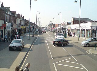
Shirley is a broad district and a former village on the western side of Southampton, in the ceremonial county of Hampshire, England. Shirley's main roles are retailing and residential. It is the most important suburban shopping area in the west of the city. Housing is a mixture of council houses in the centre of the district surrounded by private housing, with larger suburban houses concentrated in Upper Shirley. Shirley is separated from Highfield by Southampton Common, a large green public space.
The Didcot, Newbury and Southampton Railway (DN&SR) was a cross-country railway running north–south between Didcot, Newbury and Winchester. Its promoters intended an independent route to Southampton and envisaged heavy traffic from the Midlands and North of England to the port, but they ran out of funds to complete the line to Southampton. The intended heavy through traffic never materialised, and the line was dependent on larger railways—the Great Western Railway and the London and South Western Railway—for support, which was not freely given. The line opened in two stages, in 1882 and 1885.
Southampton is a city in Hampshire, England. The area has been settled since the Stone Age. Its history has been affected by its geographical location, on a major estuary on the English Channel coast with an unusual double high-tide, and by its proximity to Winchester and London; the ancient and modern capitals of England. Having been an important regional centre for centuries, Southampton was awarded city status by Queen Elizabeth II in 1964.

The Basingstoke and Alton Light Railway was opened in 1901, by the London and South Western Railway. It was the first English railway authorised under Light Railway legislation. It ran through unpromising, lightly populated terrain, and was probably built only to exclude competitors from building a line in the area. It had steep gradients and a line speed limit of 20 mph, later raised to 25 mph.
The Meon Valley Railway was a cross-country railway in Hampshire, England, that ran for 22 miles (36 km) between Alton and Fareham, closely following the course of the River Meon. At its northern (Alton) end, it joined with the Alton Line from London. It was conceived as an additional main line to the area around Gosport, and it was opened in 1903. It never fulfilled its planned potential, and remained a local line through sparsely populated agricultural areas, and it closed to passenger services in 1955; some local goods services continued until total closure in 1968.

The Salisbury and Southampton Canal was intended to be a 13-mile long canal in Hampshire and Wiltshire, southern England. Its proposed route ran from Redbridge, now a western suburb of Southampton at the head of Southampton Water, to Salisbury, and connecting with the Andover Canal at a junction near Mottisfont. Another section, through Southampton, was to connect via a tunnel to the River Itchen. Part of the canal was built and was in use by 1803, but it closed amid financial failure in 1806.
The Fullerton Junction to Hurstbourne Line was a 6-mile railway line which ran between Fullerton Junction and Hurstbourne in Hampshire, UK. It was also known as the Longparish Branch and by the nickname of Nile Valley Railway.

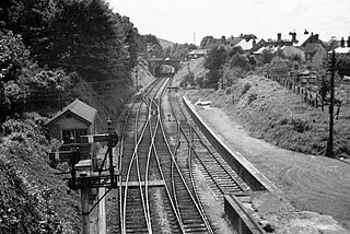
Compton railway station was a station on the Didcot, Newbury and Southampton Railway in England. Compton was the largest station between Newbury, Berkshire and Didcot, Oxfordshire, serving the villages of Compton, East Ilsley and Aldworth. The station closed in 1962.

North Stoneham is a settlement between Eastleigh and Southampton in south Hampshire, England. Formerly an ancient estate, manor, and civil parish, it is currently part of the Borough of Eastleigh. Until the nineteenth century, it was a rural community comprising a number of scattered hamlets, including Middle Stoneham, North End, and Bassett Green, and characterised by large areas of woodland.
National Cycle Route 23 is a route of the United Kingdom National Cycle Network, running from Reading to Sandown. The partially signed route passes through Basingstoke, Eastleigh and Southampton; once across the Solent, it continues through Cowes and Newport and ends in Sandown on the Isle of Wight.
Winchester (Chesil) railway station was, for the first six years after the opening of the line, the terminus of the Didcot, Newbury and Southampton Railway (DNSR), until the line was extended to link up with the Southern Railway line to Southampton. The station buildings were larger than those of any other DNSR station but were built to the standard designs used by the Great Western Railway (GWR). The station buildings were located on the northbound platform. At the northern end of the station the line passed into the double tracked Chesil Tunnel. The station also included a loading bay and single siding at its southern end accessible from the northbound line.
Winnall is a northern suburb of Winchester, Hampshire, England, on the east bank of the River Itchen.
