
Mount Albert is an inner suburb of Auckland, New Zealand, which is centred on Ōwairaka / Mount Albert, a local volcanic peak which dominates the landscape. In the past Mt. Albert also referred to the 2,500 acre borough that was created in 1911 on the outskirts of Auckland City. Mt. Albert was also one of the original five wards within the Mt. Albert Borough. The suburb is located seven kilometres to the southwest of the Central Business District (CBD).

Mount Roskill is a suburban area in the city of Auckland, New Zealand. It is named for the volcanic peak Puketāpapa.
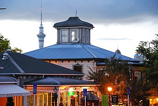
Parnell is a suburb of Auckland, New Zealand. It is one of New Zealand's most affluent suburbs, consistently ranked within the top three wealthiest, and is often billed as Auckland's "oldest suburb" since it dates from the earliest days of the European settlement of Auckland in 1841. It is characterised by its mix of tree-lined streets with large estates; redeveloped industrial zones with Edwardian town houses and 1920s bay villas; and its hilly topography that allows for views of the port, the Waitematā Harbour, Rangitoto Island and the Auckland Domain. To its west lies the Auckland Domain, to the south Newmarket, and to the north the Ports of Auckland.
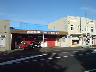
Sandringham is a suburb of Auckland, New Zealand. It is a multi-ethnic suburb with a population of over 12,000.

Wesley is a suburb of Auckland, New Zealand, located in the south-west of the Auckland isthmus. The area is a part of the Oakley Creek catchment, and in the 19th and early 20th centuries was primarily swampland owned by the Weslayan Mission. The New Zealand Government developed Wesley as a state housing area in the 1940s and 1950s.

Owairaka is a suburb of New Zealand's largest city, Auckland. It is under the local governance of the Auckland Council. The area was primarily rural until the 1930s, when the area experienced suburban growth. Owairaka is known for the Owairaka Athletic Club, a club that came to prominence in the 1960s, due to the success of coach Arthur Lydiard and athletes Murray Halberg and Peter Snell.

Kingsland is an inner-city suburb of Auckland, the largest and most populous urban area in New Zealand. Kingsland is under the local governance of the Auckland Council. It is the home of Eden Park, New Zealand's largest stadium, which hosted the finals for the 2011 Rugby World Cup. Kingsland has a village centre that contains a series of shops, restaurants, pubs and monthly markets.
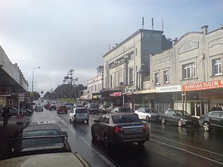
Balmoral is a suburb of Auckland, New Zealand that is bordered by Mount Eden, Epsom, Mount Roskill and Sandringham and is located approximately 5 km from the centre of Auckland. It was named around the turn of the 20th century and derives its name from Balmoral Castle, the Scottish country residence of the Royal family. Much of the housing in the area is from the 1920s and 1930s, often in the Californian Bungalow style. Balmoral was part of Mount Eden Borough Council which became a part of Auckland City in 1989. In November 2010, the area was included into the Albert-Eden-Roskill ward of the new Auckland Council.

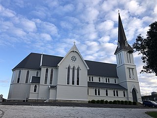
Holy Trinity Cathedral is an Anglican cathedral church situated in Parnell, a residential suburb of Auckland, New Zealand. It is the 'mother church' of the Anglican Diocese of Auckland and the seat of the Bishop of Auckland. The current main church building was consecrated in 1973.

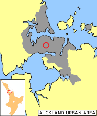
The Auckland isthmus, also known as the Tāmaki isthmus, is a narrow stretch of land on the North Island of New Zealand in the Auckland Region, and the location of the central suburbs of the city of Auckland, including the CBD. The isthmus is located between two rias : the Waitematā Harbour to the north, which opens to the Hauraki Gulf / Tīkapa Moana and Pacific Ocean, and the Manukau Harbour to the south, which opens to the Tasman Sea. The isthmus is the most southern section of the Northland Peninsula.

St Matthew's-in-the-City Church, sometimes abbreviated as St Matthew's, or commonly known as St Matthew-in-the-City, is an historic Anglican church located at 132-134 Hobson Street in the central business district of Auckland, in the North Island of New Zealand. Part of the Anglican Church in Aotearoa, New Zealand and Polynesia and the Diocese of Auckland, the church was completed in 1905 and is renowned for its Gothic Revival style.
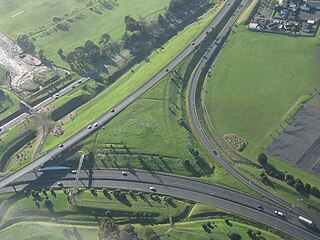
State Highway 20 (SH 20), also known as the Southwestern Motorway, is a New Zealand state highway linking State Highway 1 at Manukau with State Highway 16 in Point Chevalier, via Māngere and Onehunga. Along with its spurs, State Highway 20A and 20B, the state highway serves Auckland Airport, the country's largest, therefore making SH 20 a key arterial route connecting the airport to the wider Auckland region and most of the upper North Island. The route also forms the southern part of the Western Ring Route, a 48 kilometres (30 mi) motorway route bypassing central Auckland.
Dominion Road is an arterial road in Auckland, New Zealand, running north–south across most of the Auckland isthmus. It is a major public transport route that carries 50,000 bus passengers each week, making it one of the few roads in Auckland on which similar or greater numbers of people travel by public transport than by private car.

Oakley Creek is a creek in Auckland, New Zealand. While heavily human-modified, it has a number of important ecological features, such as having the only natural waterfall on the Auckland isthmus.
Eden Valley is an inner-city suburb of Auckland, the largest and most populous urban area in New Zealand. The suburb grew around Dominion Road, one of the Auckland's main arterial routes. Eden Valley's commercial hub is made up of a collection of businesses, shops, and dining options that service the area. The eclectic collection of shop fronts and signage on Dominion Road has aptly been described as, "colour and chaos". The "colour and chaos" of the commercial hub is strongly contrasted by the surrounding residential area. Eden Valley is characterized by heritage buildings that house modern day businesses, a residential area that has a range of late Victorian, Edwardian and transitional bay villas, and basalt and scoria stone walls that give the area a long established feel.
This is a timeline of the history of the city of Auckland in New Zealand.

The Taranaki Cathedral Church of St Mary is an Anglican cathedral church, located at 37 Vivian Street, New Plymouth, in New Zealand. Following the 2011 Christchurch earthquake, in 2016 the cathedral was closed for repairs.
The Church of the Holy Sepulchre is an historic Anglican church located at 71 Khyber Pass Road, Grafton, near the CBD of Auckland, New Zealand.

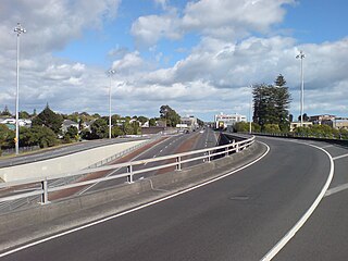
New North Road is a street in the central and western Auckland isthmus, New Zealand, connecting Upper Symonds Street in Eden Terrace to Avondale. The road runs parallel to Great North Road, located to the north, and crosses Dominion Road, the Western Line at Morningside and runs above the Waterview Tunnel section of the Southwestern Motorway at Mount Albert.

St Lukes is a suburb of New Zealand's largest city, Auckland. It is under the local governance of the Auckland Council. After Westfield St Lukes opened in 1972, the area developed into a major commercial area of the Auckland isthmus.

