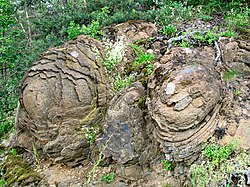
The Steinerne Rose is a rare natural monument. It is a diabase rock formation, that originated on the sea bed from outflowing lava in the middle Devonian, i.e. about 400 million years ago.[citation needed] The lava formed pillow-like bodies which have an internal structure of concentric layers. Over thousands, if not millions, of years these layers have been weathered out (exfoliation joints), giving the bodies the appearance of rosebuds in bloom.
The Steinerne Rose is located about 700metres north of Kloster, a village in the borough of Saalburg-Ebersdorf in the district of Saale-Orla-Kreis in the central German state of Thuringia, on the local road known as the Reußische Fürstenstraße (L1095), immediately on the right in front of the bridge over the old Schleiz–Saalburg railway.
There are several smaller stone roses on the Schlossfelsen rocks in Ronneburg.
Olympus Mons is a large shield volcano on Mars. It is over 21.9 km high, as measured by the Mars Orbiter Laser Altimeter (MOLA), and is about two and a half times Mount Everest's height above sea level. It is one of Mars's largest volcanoes, its tallest planetary mountain, and is approximately tied with Rheasilvia as the tallest mountain currently discovered in the Solar System. It is associated with the Tharsis Montes, a large volcanic region on Mars. It last erupted 25 million years ago.
Altenburger Land is a district in Thuringia, Germany. It is bounded by the district of Greiz, the Burgenlandkreis (Saxony-Anhalt), and the districts Leipzig, Mittelsachsen and Zwickau in Saxony. The district is a member of the Central German Metropolitan Region.
The Lassen volcanic area presents a geological record of sedimentation and volcanic activity in and around Lassen Volcanic National Park in Northern California, U.S. The park is located in the southernmost part of the Cascade Mountain Range in the Pacific Northwest region of the United States. Pacific Oceanic tectonic plates have plunged below the North American Plate in this part of North America for hundreds of millions of years. Heat and molten rock from these subducting plates has fed scores of volcanoes in California, Oregon, Washington and British Columbia over at least the past 30 million years, including these in the Lassen volcanic areas.
Diabase, also called dolerite or microgabbro, is a mafic, holocrystalline, subvolcanic rock equivalent to volcanic basalt or plutonic gabbro. Diabase dikes and sills are typically shallow intrusive bodies and often exhibit fine-grained to aphanitic chilled margins which may contain tachylite.
Mount Takahe is a 3,460-metre-high (11,350 ft) snow-covered shield volcano in Marie Byrd Land, Antarctica, 200 kilometres (120 mi) from the Amundsen Sea. It is a c. 30-kilometre-wide (19 mi) mountain with parasitic vents and a caldera up to 8 kilometres (5 mi) wide. Most of the volcano is formed by trachytic lava flows, but hyaloclastite is also found. Snow, ice, and glaciers cover most of Mount Takahe. With a volume of 780 km3 (200 cu mi), it is a massive volcano; the parts of the edifice that are buried underneath the West Antarctic Ice Sheet are probably even larger. It is part of the West Antarctic Rift System along with eighteen other known volcanoes.
The Limes Germanicus is the name given in modern times to a line of frontier fortifications that bounded the ancient Roman provinces of Germania Inferior, Germania Superior and Raetia, dividing the Roman Empire and the unsubdued Germanic tribes from the years 83 to about 260 AD. The Limes used either a natural boundary such as a river or typically an earth bank and ditch with a wooden palisade and watchtowers at intervals. A system of linked forts was built behind the Limes.
Bad Lobenstein is a spa town in the Saale-Orla-Kreis district, in Thuringia, Germany with a population of about 6,000 inhabitants. Until 2005, the town was named Lobenstein.
Fort Rock is a tuff ring located on an ice age lake bed in north Lake County, Oregon, United States. The ring is about 4,460 feet (1,360 m) in diameter and stands about 200 feet (60 m) high above the surrounding plain. Its name is derived from the tall, straight sides that resemble the palisades of a fort. The region of Fort Rock–Christmas Lake Valley basin contains about 40 such tuff rings and maars and is located in the Brothers Fault Zone of central Oregon's Great Basin. William Sullivan, an early settler in the area, named Fort Rock in 1873 while searching for lost cattle.
The Karoo Supergroup is the most widespread stratigraphic unit in Africa south of the Kalahari Desert. The supergroup consists of a sequence of units, mostly of nonmarine origin, deposited between the Late Carboniferous and Early Jurassic, a period of about 120 million years.
Neustadt am Kulm is a municipality in the district of Neustadt an der Waldnaab, in Bavaria, Germany. It is situated 29 km northwest of Weiden in der Oberpfalz, and 23 km southeast of Bayreuth. Neustadt am Kulm is situated directly west of the Rauher Kulm.
Saalburg-Ebersdorf is a town in the Saale-Orla-Kreis district, in Thuringia, Germany close to the Bavarian border. It is situated on the river Saale, 10 km southwest of Schleiz, 30 km west of Plauen and 30 km north-west of Hof.
The Saalfeld Fairy Grottoes are caverns or grottoes of a former mine near Saalfeld, in the German state of Thuringia.
The Columbia River Basalt Group is the youngest, smallest and one of the best-preserved continental flood basalt province on Earth, covering over 210,000 km2 (81,000 sq mi) mainly eastern Oregon and Washington, western Idaho, and part of northern Nevada. The basalt group includes the Steens and Picture Gorge basalt formations.
The Anahim hotspot is a hypothesized hotspot in the Central Interior of British Columbia, Canada. It has been proposed as the candidate source for volcanism in the Anahim Volcanic Belt, a 300 kilometres long chain of volcanoes and other magmatic features that have undergone erosion. This chain extends from the community of Bella Bella in the west to near the small city of Quesnel in the east. While most volcanoes are created by geological activity at tectonic plate boundaries, the Anahim hotspot is located hundreds of kilometres away from the nearest plate boundary.
The Elysium quadrangle is one of a series of 30 quadrangle maps of Mars used by the United States Geological Survey (USGS) Astrogeology Research Program. The Elysium quadrangle is also referred to as MC-15.
The Triptis–Marxgrün railway is a branch line in Germany that runs through the states of Thuringia and Bavaria, and which was originally built and operated by the Prussian state railways. It ran from Triptis via Ziegenrück, Bad Lobenstein and Blankenstein to Marxgrün. The only section still in service today is the stretch of line between Ebersdorf-Friesau and Blankenstein. The Thuringian section is also called the Oberlandbahn ; the Bavarian section the Höllentalbahn.
The Evangelical Church in Central Germany is a United church body covering most of the German states of Saxony-Anhalt and Thuringia and some adjacent areas in Brandenburg and Saxony.
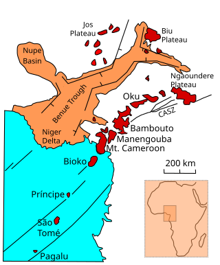
The Biu Plateau is a highland area in Northeastern Nigeria containing many recently extinct volcanoes. It covers about 5,200 km2 (2,000 sq mi) and has an average elevation of 700 m (2,300 ft). The plateau lies between the Upper Benue Basin to the south and the Chad Basin to the north. High points are Wade Hill at 775 m (2,543 ft) above sea level and Wiga Hill, at well over 800 m (2,600 ft). The plateau is the source of many tributaries of the Gongola River, which have cut deep gorges. To the north the plateau slopes gently to the Bauchi plains and the Chad Basin.
Erdmuthe Dorothea, Countess of Zinzendorf and Pottendorf was a German Pietist and hymn writer.
Elysium Planitia, located in the Elysium and Aeolis quadrangles, is a broad plain that straddles the equator of Mars, centered at 3.0°N 154.7°E. It lies to the south of the volcanic province of Elysium, the second largest volcanic region on the planet, after Tharsis. Elysium contains the major volcanoes Elysium Mons, Albor Tholus and Hecates Tholus. Another more ancient shield volcano, Apollinaris Mons, is situated just to the south of eastern Elysium Planitia. Within the plains, Cerberus Fossae is the only Mars location with recent volcanic eruptions. Lava flows dated no older than 0.2 million years from the present have been found, and evidence has been found that volcanic activity may have occurred as recently as 53,000 years ago. Such activity could have provided the environment, in terms of energy and chemicals, needed to support life forms.
This page is based on this Wikipedia article Text is available under the CC BY-SA 4.0 license; additional terms may apply. Images, videos and audio are available under their respective licenses.