
The Sacramento River is the principal river of Northern California in the United States and is the largest river in California. Rising in the Klamath Mountains, the river flows south for 400 miles (640 km) before reaching the Sacramento–San Joaquin River Delta and San Francisco Bay. The river drains about 26,500 square miles (69,000 km2) in 19 California counties, mostly within the fertile agricultural region bounded by the Coast Ranges and Sierra Nevada known as the Sacramento Valley, but also extending as far as the volcanic plateaus of Northeastern California. Historically, its watershed has reached as far north as south-central Oregon where the now, primarily, endorheic (closed) Goose Lake rarely experiences southerly outflow into the Pit River, the most northerly tributary of the Sacramento.
San Joaquin County, officially the County of San Joaquin, is a county located in the U.S. state of California. As of the 2020 census, the population was 779,233. The county seat is Stockton.

The Central Valley is a broad, elongated, flat valley that dominates the interior of California. It is 40–60 mi (60–100 km) wide and runs approximately 450 mi (720 km) from north-northwest to south-southeast, inland from and parallel to the Pacific coast of the state. It covers approximately 18,000 sq mi (47,000 km2), about 11% of California's land area. The valley is bounded by the Coast Ranges to the west and the Sierra Nevada to the east.
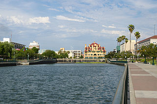
Stockton is a city in and the county seat of San Joaquin County in the Central Valley of the U.S. state of California. Stockton is the most populous city in the county, the 11th-most populous city in California and the 58th-most populous city in the United States. Stockton's population in 2020 was 320,804. It was named an All-America City in 1999, 2004, 2015, and again in 2017 and 2018. The city is located on the San Joaquin River in the northern San Joaquin Valley. It lies at the southeastern corner of a large inland river delta that isolates it from other nearby cities such as Sacramento and those of the San Francisco Bay Area.

The San Joaquin River is the longest river of Central California. The 366-mile (589 km) long river starts in the high Sierra Nevada, and flows through the rich agricultural region of the northern San Joaquin Valley before reaching Suisun Bay, San Francisco Bay, and the Pacific Ocean. An important source of irrigation water as well as a wildlife corridor, the San Joaquin is among the most heavily dammed and diverted of California's rivers.

The San Joaquin Valley is the southern half of California's Central Valley, an area drained by the San Joaquin River. Famed as a major breadbasket, the San Joaquin Valley is an important source of food, producing a significant part of California's agricultural output.

The Carquinez Strait is a narrow tidal strait located in the Bay Area of Northern California, United States. It is part of the tidal estuary of the Sacramento and the San Joaquin rivers as they drain into the San Francisco Bay. The strait is eight miles (13 km) long and connects Suisun Bay, which receives the waters of the combined rivers, with San Pablo Bay, a northern extension of the San Francisco Bay.

The Sacramento–San Joaquin River Delta, or California Delta, is an expansive inland river delta and estuary in Northern California. The Delta is formed at the western edge of the Central Valley by the confluence of the Sacramento and San Joaquin rivers and lies just east of where the rivers enter Suisun Bay, which flows into San Francisco Bay, then the Pacific Ocean via San Pablo Bay. The Delta is recognized for protection by the California Bays and Estuaries Policy. Sacramento–San Joaquin Delta was designated a National Heritage Area on March 12, 2019. The city of Stockton is located on the San Joaquin River at the eastern edge of the delta. The total area of the Delta, including both land and water, is about 1,100 square miles (2,800 km2). Its population is around 500,000.

The Mokelumne River is a 95-mile (153 km)-long river in northern California in the United States. The river flows west from a rugged portion of the central Sierra Nevada into the Central Valley and ultimately the Sacramento–San Joaquin River Delta, where it empties into the San Joaquin River-Stockton Deepwater Shipping Channel. Together with its main tributary, the Cosumnes River, the Mokelumne drains 2,143 square miles (5,550 km2) in parts of five California counties. Measured to its farthest source at the head of the North Fork, the river stretches for 157 miles (253 km).
The Port of Stockton is a major deepwater port on the Stockton Ship Channel of the Pacific Ocean and an inland port located more than seventy nautical miles from the ocean, in Stockton, California on the Stockton Channel and San Joaquin River-Stockton Deepwater Shipping Channel. The port sits on about 4,200 acres (17 km2), and occupies an island in the Sacramento–San Joaquin River Delta, and a portion of a neighborhood known as Boggs Tract. It is governed by a commission appointed by the City of Stockton and San Joaquin County. In 2012 it employed 4,500 people and made about $4.9 million in local tax funds.

The following outline is provided as an overview of and topical guide to the U.S. state of California.

Staten Island is an island in the Sacramento-San Joaquin River Delta, twenty-five kilometres northwest of Stockton. The 3,700 ha is bordered on the east and south by South Mokelumne River, and on the west and north by North Mokelumne River. It is in San Joaquin County, and managed by Reclamation District 38.

The Great Valley Sequence of California is a 40,000-foot (12 km)-thick group of related geologic formations that are Late Jurassic through Cretaceous in age on the geologic time scale. These sedimentary rocks were deposited during the late Mesozoic Era in an ancient seaway that corresponds roughly to the outline of the modern Great Valley of California.

Stockton Deepwater Shipping Channel also called the Baldwin-Stockton Deepwater Shipping Channel or Stockton Deep Water Channel is a manmade deepwater water channel that runs from Suisun Bay and the Sacramento River - Sacramento Deep Water Ship Channel to the Port of Stockton and the Stockton Channel in California. The Stockton Ship Channel is 41 mi (66 km) long and about 37 ft (11 m) deep, allowing up to Panama Canal size ocean ships access to the Port of Stockton at the City of Stockton. The Stockton Deepwater Shipping Channel is part of the vast Sacramento–San Joaquin River Delta that has a connection to the Pacific Ocean. Stockton Deepwater Shipping Channel is also called the lower San Joaquin River.

Acker Island is a small island in the Sacramento–San Joaquin River Delta. It is part of San Joaquin County, California. Its coordinates are 37°59′51″N121°26′56″W, and the United States Geological Survey measured its elevation as 3 ft (0.91 m) in 1981. It appears on a 1952 USGS map of the area.

Atherton Island is a small island in the Sacramento–San Joaquin River Delta. It is in unincorporated San Joaquin County, California, part of Stockton. Its coordinates are 37°57′22″N121°21′01″W, and the United States Geological Survey measured its elevation as 13 ft (4.0 m) in 1999. It appears on a 2015 USGS map of the area.

Tule Island is a small island in the Sacramento–San Joaquin River Delta, which exists as part of a complex of islands including directly-adjacent Fern Island and Headreach Island. It is a naturally-formed island, which was used in the early 20th century to farm potatoes, but now consists mostly of marsh. It is currently a habitat for waterfowl and is used as a fishing spot.
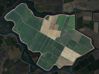
The Rindge Tract is an island in the Sacramento–San Joaquin River Delta. It is part of San Joaquin County, California, and managed by Reclamation District 2037. Its coordinates are 38°01′20″N121°26′05″W, and the United States Geological Survey measured its elevation as −3 ft (−0.91 m) in 1981. It appears on a 1952 USGS map of the area.

The Empire Tract is an island in the Sacramento–San Joaquin River Delta in San Joaquin County, California, United States. It has been used for agriculture since the 1800s; in the early 20th century it was used to plant potatoes, and United States president Herbert Hoover operated a beet farm there. In the 1960s, natural gas deposits were discovered beneath the island. In 1936, it was connected to the mainland by the Eight Mile Road Bridge, across King Island. As with many islands in the Delta, the Empire Tract has experienced considerable subsidence, and is well below sea level.

The Wright-Elmwood Tract is an island in the Sacramento–San Joaquin River Delta. It is part of San Joaquin County, California, and managed by Reclamation District 2119. Its coordinates are 37°59′23″N121°22′50″W, and the United States Geological Survey measured its elevation as 0 ft (0 m) in 1981.