
The Ikara-Flinders Ranges National Park is situated approximately 400 km north of Adelaide in the northern central part of South Australia's largest mountain range, the Flinders Ranges. The park covers an area of 912 km², northeast of the small town of Hawker. The Heysen Trail and Mawson Trails pass through the park.
Kalbarri National Park is located 485 km (301 mi) north of Perth, in the Mid West region of Western Australia.

Sir Roderick Impey Murchison, 1st Baronet, was a British geologist who first described and investigated the Silurian system.
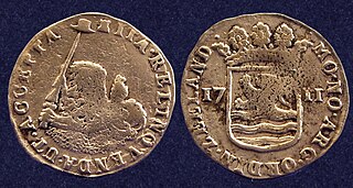
The Zuytdorp, also Zuiddorp was an 18th-century trading ship of the Dutch East India Company

Diabase or dolerite or microgabbro is a mafic, holocrystalline, subvolcanic rock equivalent to volcanic basalt or plutonic gabbro. Diabase dikes and sills are typically shallow intrusive bodies and often exhibit fine grained to aphanitic chilled margins which may contain tachylite. Diabase is the preferred name in North America, yet dolerite is the preferred name in most of the rest of the world, where sometimes the name diabase is applied to altered dolerites and basalts. Many petrologists prefer the name microgabbro to avoid this confusion.

The Murchison River is the second longest river in Western Australia. It flows for about 820 km (510 mi) from the southern edge of the Robinson Ranges to the Indian Ocean at Kalbarri. The Murchison-Yalgar-Hope river system is the longest river system in Western Australia. It has a mean annual flow of 208 gigalitres, although in 2006, the peak year on record since 1967, flow was 1,806 gigalitres.

Kalbarri is a coastal town in the Mid West region located 592 km (368 mi) north of Perth, Western Australia. The town is found at the mouth of the Murchison River and has an elevation of 6 metres (20 ft). It is connected by public transport to Perth via Transwa coach services N1 and N2.

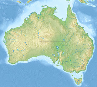
The geology of Australia includes virtually all known rock types and from all geological time periods spanning over 3.8 billion years of the Earth's history. Australia is a continent situated on the Indo-Australian Plate.
Tamala Limestone is the geological name given to the widely occurring eolianite limestone deposits on the western coastline of Western Australia, between Shark Bay in the north and nearly to Albany in the south. The rock consists of calcarenite wind-blown shell fragments and quartz sand which accumulated as coastal sand dunes during the middle and late Pleistocene and early Holocene eras. As a result of a process of sedimentation and water percolating through the shelly sands, the mixture later lithified when the lime content dissolved to cement the grains together.

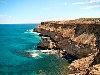
The Zuytdorp Cliffs extend for about 150 km (93 mi) along a rugged, spectacular and little visited segment of the Western Australian Indian Ocean coast. The cliffs extend from just south of the mouth of the Murchison River at Kalbarri, to Pepper Point south of Steep Point. The cliffs are situated in both the Gascoyne and Mid West regions of the state.
The Tumblagooda Sandstone is a geological formation deposited during the Silurian or Ordovician periods, between four and five hundred million years ago, and is now exposed on the west coast of Australia in river and coastal gorges near the tourist town of Kalbarri, Kalbarri National Park and the Murchison River gorge, straddling the boundary of the Carnarvon and Perth basins. Visible trackways are interpreted by some to be the earliest evidence of fully terrestrial animals.

Western Australia has the longest coastline of any state or territory in Australia, at 10,194 km or 12,889 km. It is a significant portion of the coastline of Australia, which is 35,877 km.
The Z Bend is a popular tourist lookout on the Murchison River Gorge in Western Australia. It is located at 27°39′19″S114°27′19″E, about 30 kilometres east of Kalbarri, in the Kalbarri National Park. One of four lookouts in the national park, it is situated on a sharp bend in the gorge. The view includes an excellent section through the Tumblagooda Sandstone, a geological sequence of fluvial and coastal deposits over a kilometre deep.
Grey's Spring, sometimes called Grey's Well, is a historical site in Kalbarri, Western Australia. It is a stone-lined well dating from after 1848, named after Lieutenant George Grey whose boats were wrecked in the surf of Gantheaume Bay on 1 April 1839, during his second disastrous exploration expedition along the Western Australian coast. It has a grid cover installed for safety reasons, and a commemorative plaque. It is located at Kalbarri Lions Park, located off Walker Street.
Shell House is an area of coastal cliffs located between Red Bluff and Bluff Point in Kalbarri National Park in Mid West Western Australia. They are highly regarded for their scenery, and also for the exposures of geological strata, which include Ordovician Tumblagooda sandstone, Triassic Wittecarra sandstone and Kockatea shale. The Shell House cliffs have been listed on Australia's Register of the National Estate since 1978.
The Miria Formation is a Late Cretaceous geologic formation. Possible indeterminate theropod remains have been recovered from it, as well as those of sea turtles, and possible azhdarchid pterosaurs. The lithology of the unit consists of calcarenite with abundant phosphatic nodules.
Lynton is a townsite in the Mid West region of Western Australia. It is part of a larger rural district known as Yallabatharra. Lynton is situated at the mouth of the Hutt River, 7.6 kilometres by road from Gregory – between the larger towns of Northampton and Kalbarri. Lynton is best known as the site of the former Lynton Convict Hiring Depot.
Mount Narryer or Mount Narryer Station is a pastoral lease that operates as a cattle station and had previously operated as a sheep station.
Murchison House Station is a pastoral lease that once operated as a sheep station but now rears cattle and goats in Western Australia.

