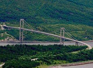
The Rombak Bridge is a suspension bridge in Narvik Municipality in Nordland county, Norway. The bridge crosses the Rombaken fjord near the town of Narvik. The 765-metre-long (2,510 ft) bridge was opened in 1964. The main span is 325 metres (1,066 ft) and the maximum clearance to the sea is 41 metres (135 ft).

Harstad/Narvik Airport, Evenes is an international airport located in Evenes Municipality in Nordland county, Norway. The airport serves the towns of Harstad and Narvik. It is co-located with Evenes Air Station of the Royal Norwegian Air Force. The civilian sector is owned and operated by the state-owned Avinor and handled 654,977 passengers in 2013. Evenes has a 2,808-meter (9,213 ft) runway, a parallel taxiway and a terminal with five gates. The airlines with daily scheduled services are Norwegian Air Shuttle, Scandinavian Airlines (SAS) and Widerøe. Destinations with daily services are Oslo, Trondheim, Bodø, Tromsø and Andenes. Evenes is the only primary airport in Central Hålogaland and its catchment area for Oslo-bound flights includes Lofoten and Vesterålen.

Bjerkvik is a village in Narvik Municipality in Nordland county, Norway. The village is located at the end of Herjangsfjorden, an arm of Ofotfjorden. Bjerkvik sits less than 20 kilometres (12 mi) south of the border of Troms county and about 13 kilometres (8.1 mi) across the fjord from the town of Narvik. The 1.34-square-kilometre (330-acre) village has a population (2018) of 1,159 which gives the village a population density of 865 inhabitants per square kilometre (2,240/sq mi).

Straumsnes or Strømsnes is a village in the municipality of Fauske in Nordland county, Norway. It is located in the Valnesfjord area of Fauske. The town of Fauske lies 15 kilometres (9.3 mi) to the east and the town of Bodø lies about 40 kilometres (25 mi) to the west. The village sits just inland of Skjerstad Fjord, along the southern shore of the lake Valnesfjordvatnet.

Narvik Airport, Framnes was a regional airport in Narvik Municipality in Nordland county, Norway. It was located at Framnes in the town of Narvik, along the Ofotfjorden. It was operated by the state-owned Avinor and consisted of a 965-meter (3,166 ft) runway aligned 01–19.
Katterat Station is a railway station in the municipality of Narvik in Nordland county, Norway. The station is located along the Ofotbanen railway line, between Rombak Station and Søsterbekk Station.
The Polar Line is an incomplete and abandoned railway line from Fauske, Norway, to Narvik and, if finished, ultimately would have run 1,215 km (755 mi) to Kirkenes.
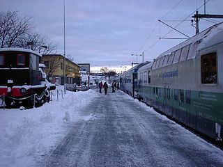
Narvik is a railway station located in Narvik Municipality in Nordland, Norway on the Ofoten Line. The station is located in the town of Narvik, about 3.7 kilometres (2.3 mi) from the line terminus at the Port of Narvik. It is served by three daily passenger trains from, respectively, Kiruna, Luleå and Stockholm in Sweden. These passenger services are currently operated by Transdev. The station is located at an elevation of 46.6 metres (153 ft) above sea level and is located 1,579.9 kilometres (981.7 mi) from Stockholm. It was opened in 1902 along with Ofotbanen and the Iron Ore Line.

Torgeir Trældal is a Norwegian politician and member of parliament from representing Nordland for the Progress Party.
Søsterbekk Station is a railway station in the municipality of Narvik in Nordland county, Norway. It is located along the Ofotbanen railway line, between Katterat Station and Bjørnfjell Station. It has direct railway connections to Narvik, Kiruna, and Luleå.

Vidrek is a small village in Narvik Municipality in Nordland county, Norway. The village is located along the Ofotfjorden, just east of the Skjomen fjord. The population of the village is about 70.

Bjørnfjell Station is a railway station in the village of Bjørnfjell in the municipality of Narvik in Nordland county, Norway. It is located along the Ofotbanen railway line, between Søsterbekk Station and Riksgränsen Station. It is about 40 kilometres (25 mi) from Narvik Station and 1.5 kilometres (0.93 mi) from the Swedish border.

The Hålogaland Bridge is a suspension bridge which crosses the Rombaksfjorden in Narvik Municipality in Nordland county, Norway. It is the second-longest bridge span in Norway. The bridge is part of the European Route E6 highway. It was built to shorten the driving distance from the town of Narvik to the village of Bjerkvik by 17 kilometers (11 mi) and from Narvik to Bjørnfjell, via European Route E10 by 5 kilometers (3.1 mi). The bridge cost 2.2 billion kr. Financing came from a mix of state grants and tolls.
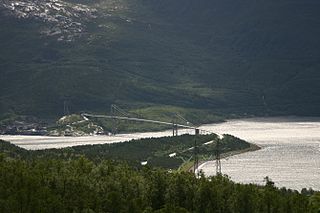
Rombaken (Norwegian) or Ruoppat (Northern Sami) is a fjord that branches off of the main Ofotfjorden in Narvik Municipality in Nordland county, Norway. The fjord is about 20 kilometres (12 mi) long and is surrounded by steep mountainsides and the town of Narvik lies on the south shore of the mouth of the fjord. The European route E06 and European route E10 highways run along the northern shores of the fjord. The fjord has two bridge crossings: the Hålogaland Bridge, completed in 2018, crosses at mouth of the Rombaken fjord and the Rombak Bridge which crosses at a narrow point about mid-way down the fjord.
Hergot (Norwegian) or Hearrágoahti (Northern Sami) is a village in Narvik Municipality in Nordland county, Norway. The village is located along the Rombaken fjord, just north of the Rombak Bridge. Hergot Chapel is located on the south side of the village, along the European route E06 highway.
Elvegård is a village in Narvik Municipality in Nordland county, Norway. The village is located along the Skjomen fjord. Skjomen Church is located in the village on the shore of the fjord. There is a golf course in Elvegård, located along the river Elvegårdselva.
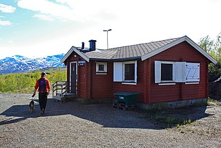
Bjørnfjell is a mountain and village of holiday cottages in Narvik Municipality in Nordland county, Norway. It's located along the Ofotbanen railway line and the European route E10 highway, just west of the border with Sweden. There is a railway station and the Bjørnfjell Chapel as well as many cabins and homes in the area. The name Bjørnfjell for short may often refer to the Bjørnfjell Railway Station. The area is a popular vacation spot for residents of Narvik.


