
The City of Fort St. John is a city in northeastern British Columbia, Canada. A member municipality of the Peace River Regional District, the city encompasses a total area of about 22 square kilometres (8.5 sq mi) with 18,609 residents at the 2011 census Located at Mile 47, it is one of the largest cities along the Alaska Highway. Originally established in 1794, as a trading post, Fort St. John is the oldest European-established settlement in present-day British Columbia. Fort St. John is served by the Fort St. John Airport. The municipal slogan is Fort St. John: The Energetic City.
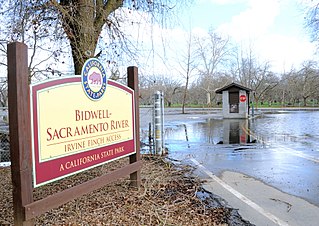
Bidwell–Sacramento River State Park is a state park of California, United States, preserving riparian habitat on the Sacramento River and its tributary Big Chico Creek. The park is located on the border of Butte County and Glenn County. Popular activities include fishing for salmon, steelhead and shad; and floating the river on inner tubes, canoes or kayaks. The 349-acre (141 ha) property was established as a state park in 1979.

Dawson Creek is a city in northeastern British Columbia, Canada. The municipality of 24.37 square kilometres (9.41 sq mi) had a population of 11,583 in 2011. Dawson Creek derives its name from the creek of the same name that runs through the community. The creek was named after George Mercer Dawson by a member of his land survey team when they passed through the area in August 1879. Once a small farming community, Dawson Creek became a regional centre after the western terminus of the Northern Alberta Railways was extended there in 1932. The community grew rapidly in 1942 as the US Army used the rail terminus as a transshipment point during construction of the Alaska Highway. In the 1950s, the city was connected to the interior of British Columbia via a highway and railway through the Rocky Mountains. Since the 1960s, growth has slowed.

Ocmulgee National Monument preserves traces of over ten millennia of Southeastern Native American culture, including major earthworks built before 1000 CE by the South Appalachian Mississippian culture These include the Great Temple and other ceremonial mounds, a burial mound, and defensive trenches. They represented highly skilled engineering techniques and soil knowledge, and the organization of many laborers. The site has evidence of "17,000 years of continuous human habitation." The 702-acre (2.84 km2) park is located on the east bank of the Ocmulgee River. Present-day Macon, Georgia developed around the site after the United States built Fort Benjamin Hawkins nearby in 1806.

The Peace–Athabasca Delta, located in northeast Alberta, is the largest freshwater inland river delta in North America. It is located partially within the southeast corner of Wood Buffalo National Park, Canada's largest national park, and also spreads into the Regional Municipality of Wood Buffalo, west and south of the historical community of Fort Chipewyan. The delta encompasses approximately 321,200 ha, formed where the Peace and Athabasca rivers converge on the Slave River and Lake Athabasca. The delta region is designated a wetland of international importance and a UNESCO World Heritage Site. The region is large enough that it is considered one of twenty distinct natural subregions of Alberta by the provincial government's Natural Regions Committee.

The Kasilof River or Ggasilatnu in the Dena'ina language is a river on the western Kenai Peninsula in southern Alaska. The name is an anglicization of Reka Kasilova, the name given to the river by early Russian settlers in the area. It begins at Tustumena Lake and flows northwest to Cook Inlet near Kasilof. The upper section of the river is very swift, with several sections considered Class II whitewater, and underwater hazards are difficult to detect, due to the silty nature of the glacial runoff that comprises most of the river. The entire river has powerful currents and is very cold. There is public access to the lower section from the Sterling Highway. Drift and bank fishing for salmon is popular on the lower Kasilof.

Curecanti National Recreation Area is a National Park Service unit located on the Gunnison River in western Colorado. Established in 1965, Curecanti is responsible for developing and managing recreational facilities on three reservoirs, Blue Mesa Reservoir, Morrow Point Reservoir and Crystal Reservoir, constructed on the upper Gunnison River in the 1960s by the U.S. Bureau of Reclamation to better utilize the vital waters of the Colorado River and its major tributaries. A popular destination for boating and fishing, Curecanti offers visitors two marinas, traditional and group campgrounds, hiking trails, boat launches, and boat-in campsites. The state's premiere lake trout and Kokanee salmon fisheries, Curecanti is a popular destination for boating and fishing, and is also a popular area for ice-fishing in the winter months.

Williston Lake is a reservoir created by the W. A. C. Bennett Dam and is located in the Northern Interior of British Columbia, Canada.

Clear Creek State Park is a 1,211.19-acre (490.15 ha) Pennsylvania state park in Barnett and Heath Townships, Jefferson County, Pennsylvania in the United States. Public campsites were first opened at the park in 1922. Many of the facilities seen today at the park were constructed during the Great Depression by the Civilian Conservation Corps. Clear Creek State Park is 12 miles (19 km) from Brookville on Pennsylvania Route 949 at the confluence of Clear Creek and the Clarion River.

Paynes Creek Historic State Park is a Florida State Park located on Lake Branch Road one-half mile southeast of Bowling Green, Florida. On November 21, 1978, it was added to the United States National Register of Historic Places, under the title of Payne's Creek Massacre-Fort Chokonikla Site.
Peace River Corridor Provincial Park is a 2014 ha provincial park in British Columbia, Canada.

Waterton Lake is a mountain lake in southern Alberta, Canada and northern Montana, United States. The lake is composed of two bodies of water, connected by a shallow channel known locally as the Bosporus. The two parts are referred to as Middle Waterton Lake, and Upper Waterton Lake, the latter of which is divided by the Canada–United States border with Canada having about two thirds of the lake while the United States has the Southern third. The United States Geological Survey gives the geocoordinates of 49°03′00″N113°54′03″W for Upper Waterton Lake. There is also Lower Waterton Lake which is located located to the North of Middle Waterton Lake, it is separated by a channel known as the Dardanelles.

The Smoky River is a river in western Alberta, Canada. It is a major tributary of the Peace River. The descriptive name refers to the presence of "smouldering beds of coal in the riverbank" noted by the Cree Indians.

Kiskatinaw is a tributary of the Peace River in northeastern British Columbia, Canada.

The history of Idaho in the American Civil War is atypical, as the territory was far from the battlefields.

Bluestone Wildlife Management Area is a wildlife management area in southern West Virginia surrounding Bluestone Lake and the New River. The section of the lake from just upstream of the Bluestone River to Bluestone Dam is in Bluestone State Park; the rest of the lake in West Virginia basin comprises Bluestone WMA. Altogether, the WMA comprises 18,019 acres (72.92 km2) of land and water.

The Medicine Lodge Peace Treaty Site was the location in present-day Kansas of the signing of the Medicine Lodge Treaty in October 1867 by the United States government with major Western Native American tribes of the region. The treaty, whose peace lasted less than one year, was the first in which the United States formally adopted the policy of attempting to acculturate Native Americans to European ways. The treaty site is located south of Medicine Lodge, around the confluence of Elm Creek and the Medicine Lodge River; it was designated a U.S. National Historic Landmark in 1969 and is listed on the National Register of Historic Places.

