Sediment is a naturally occurring material that is broken down by processes of weathering and erosion, and is subsequently transported by the action of wind, water, or ice or by the force of gravity acting on the particles. For example, sand and silt can be carried in suspension in river water and on reaching the sea bed deposited by sedimentation and if buried, may eventually become sandstone and siltstone.
Historical geology or paleogeology is a discipline that uses the principles and techniques of geology to reconstruct and understand the geological history of Earth. It focuses on geologic processes that change the Earth's surface and subsurface; and the use of stratigraphy, structural geology and paleontology to tell the sequence of these events. It also focuses on the evolution of plants and animals during different time periods in the geological timescale. The discovery of radioactivity and the development of several radiometric dating techniques in the first half of the 20th century provided a means of deriving absolute versus relative ages of geologic history.

An unconformity is a buried erosional or non-depositional surface separating two rock masses or strata of different ages, indicating that sediment deposition was not continuous. In general, the older layer was exposed to erosion for an interval of time before deposition of the younger, but the term is used to describe any break in the sedimentary geologic record. The significance of angular unconformity was shown by James Hutton, who found examples of Hutton's Unconformity at Jedburgh in 1787 and at Siccar Point in 1788.

Of the many unconformities (gaps) observed in geological strata, the term Great Unconformity is frequently applied to either the unconformity observed by James Hutton in 1787 at Siccar Point in Scotland, or that observed by John Wesley Powell in the Grand Canyon in 1869. Both instances are exceptional examples of where the contacts between sedimentary strata and either sedimentary or crystalline strata of greatly different ages, origins, and structure represent periods of geologic time sufficiently long to raise great mountains and then erode them away.

Lithostratigraphy is a sub-discipline of stratigraphy, the geological science associated with the study of strata or rock layers. Major focuses include geochronology, comparative geology, and petrology. In general a stratum will be primarily igneous or sedimentary relating to how the rock was formed.
The Straight Cliffs Formation is a stratigraphic unit in the Kaiparowits Plateau of south central Utah. It is Late Cretaceous in age and contains fluvial, paralic, and marginal marine (shoreline) siliciclastic strata. It is well exposed around the margin of the Kaiparowits Plateau in the Grand Staircase – Escalante National Monument in south central Utah. The formation is named after the Straight Cliffs, a long band of cliffs creating the topographic feature Fiftymile Mountain.
The Messinian Erosional Crisis is a phase in the Messinian evolution of the central Mediterranean basin resulting from major drawdown of the Mediterranean seawater.

The Cambrian Tonto Group is the three-member sequence of geologic formations that represent the basal section of Paleozoic rocks in the Grand Canyon. The group is about 1,250 feet (381 m) thick. The base unit, the Cambrian Tapeats Sandstone was deposited upon the erosion surface of the Vishnu Basement Rocks, which is found in Granite Gorge. The erosion resistant Tapeats Sandstone forms the platform, called Tonto Platform, that the two less erosion resistant upper layers, the Bright Angel Shale and Muav Limestone, rest on.

The Cambrian Muav Limestone is the upper geologic unit of the 3-member Tonto Group. It is about 650 feet (198 m) thick at its maximum. It is a resistant cliff-forming unit. The Muav consists of dark to light-gray, brown, and orange red limestone with dolomite and calcareous mudstone. The Muav is overlain in some areas by the Devonian Temple Butte Limestone, but the major unit above are the vertical cliffs of Mississippian Redwall Limestone. The Muav is located in the lower elevations of the Grand Canyon, Arizona.

The Unkar Group is a sequence of strata of Proterozoic age that are subdivided into five geologic formations and exposed within the Grand Canyon, Arizona, Southwestern United States. It is about 1,600 to 2,200 m thick and composed, in ascending order, of the Bass Formation, Hakatai Shale, Shinumo Quartzite, Dox Formation, and Cardenas Basalt. It accumulated approximately between 1250 and 1104 Ma. In ascending order, the Unkar Group is overlain by the Nankoweap Formation, about 113 to 150 m thick; the Chuar Group, about 1,900 m (6,200 ft) thick; and the Sixtymile Formation, about 60 m (200 ft) thick. The Nankoweap and Sixtymile formations together with the Chuar and Unkar groups comprise the Grand Canyon Supergroup.

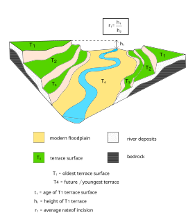
Terraces can be formed in many ways and in several geologic and environmental settings. By studying the size, shape, and age of terraces, one can determine the geologic processes that formed them. When terraces have the same age and/or shape over a region, it is often indicative that a large-scale geologic or environmental mechanism is responsible. Tectonic uplift and climate change are viewed as dominant mechanisms that can shape the earth’s surface through erosion. River terraces can be influenced by one or both of these forcing mechanisms and therefore can be used to study variation in tectonics, climate, and erosion, and how these processes interact.

The Nias Basin is a forearc basin located off the western coast of Sumatra, Indonesia, in the Indian Ocean. The name is derived from the island that bounds its western edge, the island of Nias. The Nias Basin, the island of Nias, and the offshore, submarine accretionary complex, together form a Forearc region on the Sunda Plate/Indo-Australian Plate collisional/subduction boundary. The Forearc region is the area between an oceanic trench and its associated volcanic arc. The oceanic trench associated with the Nias Basin is the Sunda Trench, and the associated volcanic arc is the Sunda Arc.
Marine flooding surfaces are a fundamental concept in sequence stratigraphy, where they form the limiting surfaces of parasequences.
Accommodation is a fundamental concept in sequence stratigraphy, a subdiscipline of geology. It is defined as the space that is available for the deposition of sediments.
In geology, a diastem is a short interruption in sedimentation with little or no erosion. They can also be described as very short unconformities.
In sequence stratigraphy, a sub discipline of geology, type 1 sequences and type 2 sequences are special sequences that are defined by having by distinct types of sequence boundaries. In modern literature, the distinction in type 1 sequences and type 2 sequences was abandoned.

The Ipubi Formation is the middle geological formation of the Santana Group, the middle part of the Araripe Group, in the Araripe Basin of northeastern Brazil. The formation is dated to the Aptian to Albian stages of the Early Cretaceous, unconformably overlying the Crato Formation and unconformably overlain by the Romualdo Formation, formerly known as the Romualdo Member of the Santana Formation. The averaging 15 metres (49 ft) thick Ipubi Formation comprises shales and sandstones in the lower section and evaporites in the upper part of the formation, deposited in a transgressive to highstand lacustrine environment in the Araripe rift basin.


