Suhle (Hahle)

Last updated

Suhle
Landolfshausen Ost.JPG
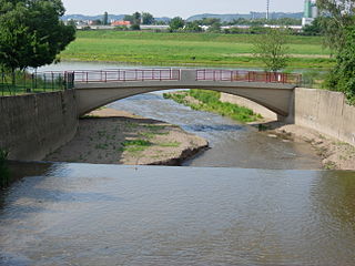
The Suhle below Landolfshausen
Location
Country Germany
State Lower Saxony
Physical characteristics
Source 
 - locationIn Mackenrode  [ de ], a district of Landolfshausen
 - coordinates 51°31′46″N10°03′54″E / 51.5294°N 10.0649°E / 51.5294; 10.0649
Mouth  
 - location
In Gieboldehausen into the Hahle
 - coordinates
51°36′33″N10°12′41″E / 51.6092°N 10.2115°E / 51.6092; 10.2115 Coordinates: 51°36′33″N10°12′41″E / 51.6092°N 10.2115°E / 51.6092; 10.2115
Basin features
Progression HahleRhumeLeineAllerWeserNorth Sea

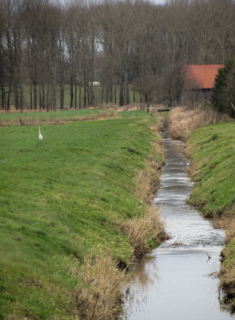
Suhle is a river of Lower Saxony, Germany.

The Suhle springs in Mackenrode  [ de ], a district of Landolfshausen. [1] It is a left tributary of the Hahle in Gieboldehausen. [2]

Landolfshausen Place in Lower Saxony, Germany

Landolfshausen is a municipality in the district of Göttingen, in Lower Saxony, Germany. One of the constituent villages of the municipality is Falkenhagen.

Hahle river in Germany

Hahle is a river of Thuringia and of Lower Saxony, Germany. It joins the Rhume in Gieboldehausen.

Gieboldehausen Place in Lower Saxony, Germany

Gieboldehausen is a municipality in the district of Göttingen, in Lower Saxony, Germany. It is situated on the river Rhume, approx. 25 km northeast of Göttingen, and 15 km south of Osterode am Harz. It is part of the Eichsfeld.

See also

Related Research Articles

Aland (river) river in Germany

The Aland is a river in the German states of Lower Saxony and Saxony-Anhalt, left tributary of the Elbe. It is the continuation of the river Biese, which is the continuation of the river Milde. The Aland is 27 kilometres (17 mi) long, whereas the total Milde-Biese-Aland system is 97 kilometres (60 mi) long. The Aland flows into the Elbe in Schnackenburg.

Weißeritz river in Germany

The Weißeritz is a river of Saxony, Germany. It is 13.7 km [8.5 mi] long and a left tiburary of the Elbe.

The Aue is a meandering stream in Lower Saxony, Germany.

Kleine Röder (Black Elster) river in Germany

The Kleine Röder, also called the Schwarzgraben, is a river in Saxony and Brandenburg, Germany.

Violenbach river in Lower Saxony, Germany.

Violenbach is a river of Lower Saxony and North Rhine-Westphalia, Germany.

Schaler Aa is a river of Lower Saxony and North Rhine-Westphalia, Germany. It flows into the Große Aa south of Freren.

Neue Luppe

Neue Luppe is an artificial river of Saxony and Saxony-Anhalt, Germany.

Schwarzer Graben (Elbe) river in Germany

The Schwarzer Graben is a river of Saxony, Germany.

Alte Elbe is the German name for oxbows of the Elbe, i.e. cut-off meanders. With about 20 km (12 mi) the largest one of these is the Dornburger Alte Elbe, a river of Saxony-Anhalt, Germany.

The Treba is a river of Saxony, Germany.

The Milde is a river in the German state of Saxony-Anhalt, source river of the Biese. It is 36 kilometres (22 mi) long, whereas the total Milde-Biese-Aland system is 97 kilometres (60 mi) long. The Milde flows into the Biese near Meßdorf.

Ichte river in Germany

Ichte, in its upper course also called Steinaer Bach, is a river of Thuringia and Lower Saxony, Germany.

Allerbach is a river of Saxony-Anhalt, Germany.

Suhle may refer to:

Beberbach is a river of North Rhine-Westphalia and Lower Saxony, Germany.

Allerbach is a river of Lower Saxony, Germany.

Braker Sieltief is a river of Lower Saxony, Germany.

Spüligbach (Ilme) River in Germany

Spüligbach is a river of Lower Saxony, Germany.

Spüligbach is a river of Lower Saxony, Germany.

Alte Hehlenriede River in Germany

Alte Hehlenriede is a river of Lower Saxony, Germany.

References

  1. Google (12 March 2019). "Suhle source" (Map). Google Maps . Google. Retrieved 12 March 2019.
  2. Google (12 March 2019). "Suhle mouth" (Map). Google Maps . Google. Retrieved 12 March 2019.