Africa is a continent comprising 63 political territories, representing the largest of the great southward projections from the main mass of Earth's surface. Within its regular outline, it comprises an area of 30,368,609 km2 (11,725,385 sq mi), excluding adjacent islands. Its highest mountain is Mount Kilimanjaro, its largest lake is Lake Victoria

The Central African Republic is a landlocked nation within the interior of the African continent. It is bordered by the countries of Cameroon, Chad, Sudan, South Sudan, the Democratic Republic of the Congo and the Republic of the Congo. Much of the country consists of flat, or rolling plateau savanna, about 1,640 feet (500 m) above sea level. In the northeast are the Fertit Hills, and there are scattered hills in the southwestern part of the country. To the northwest are the Karre Mountains, a granite plateau with an altitude of 3,750 feet (1,143 m).

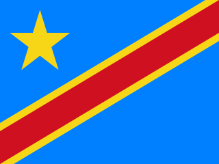
Sparsely populated in relation to its area, the Democratic Republic of the Congo is home to a vast potential of natural resources and mineral wealth. Despite this, the economy has declined drastically since the mid-1980s.

Katanga was one of the eleven provinces of the Democratic Republic of the Congo between 1966 and 2015, when it was split into the Tanganyika, Haut-Lomami, Lualaba and Haut-Katanga provinces. Between 1971 and 1997, its official name was Shaba Province.

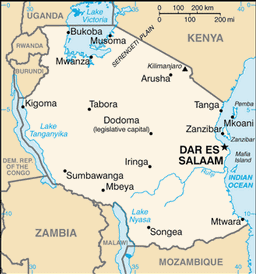
Tanzania comprises many lakes, national parks, and Africa's highest point, Mount Kilimanjaro.

Zambia is a landlocked country located in Southern Africa, to the east of Angola. It has a total area of 752 618 square kilometres, of which 9 220 km² are water.

Kinshasa is the capital and the largest city of the Democratic Republic of the Congo. The city is situated alongside the Congo River.

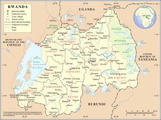
Rwanda is located in central Africa, to the east of the Democratic Republic of the Congo, at the co-ordinates 2°00′S30°0′E.
This is a list of lists of universities and colleges by country, sorted by continent and region. The lists represent educational institutions throughout the world which provide higher education in tertiary, quaternary, and post-secondary education.

The Ubangi River, also spelled Oubangui, is the largest right-bank tributary of the Congo River in the region of Central Africa. It begins at the confluence of the Mbomou and Uele Rivers and flows west, forming the border between Central African Republic (CAR) and Democratic Republic of the Congo. Subsequently, the Ubangi bends to the southwest and passes through Bangui, the capital of the CAR, after which it flows south – forming the border between Democratic Republic of the Congo and Republic of Congo. The Ubangi finally joins the Congo River at Liranga.

Kisangani is the capital of Tshopo province in the Democratic Republic of the Congo. It is the third largest urbanized city in the country and the largest of the cities that lie in the tropical woodlands of the Congo.

The Congo Basin is the sedimentary basin of the Congo River. The Congo Basin is located in Central Africa, in a region known as west equatorial Africa. The Congo Basin region is sometimes known simply as the Congo.
The G90, otherwise known as the Group of 90, is an alliance between the poorest and smallest developing countries, many of whom are part of the World Trade Organization (WTO). The G90 emerged as a strong grouping at the WTO’s Ministerial conference at Cancun in September 2003, taking common positions representing the largest number of countries, with 64 of the 90 countries in the G90 being members of the WTO. It is the largest trading body in the WTO, and it was formed as an umbrella body including the African, Caribbean and Pacific Group (ACP), the African Union, and the group of Least Developed Countries (LDC).
The Canadian territory of Nunavut covers about 1.9 million square kilometres of land and water including part of the mainland, most of the Arctic Islands, and all of the islands in Hudson Bay, James Bay, and Ungava Bay which belonged to the Northwest Territories. This makes it the fifth largest country subdivision in the world. If Nunavut were a country, it would rank 13th in area, after the Democratic Republic of the Congo. Nunavut has land borders with Manitoba, the Northwest Territories on several islands as well as the mainland, and a tiny land border with Newfoundland and Labrador on Killiniq Island. Nunavut also has small land borders with Ontario and Quebec.

The Republic of the Congo, also known as Congo-Brazzaville, the Congo Republic or simply the Congo, is a country located in the western coast of Central Africa. It is bordered by five countries: Gabon to its west; Cameroon to its northwest and the Central African Republic to its northeast; the Democratic Republic of the Congo to the southeast and the Angolan exclave of Cabinda to its south; and the Atlantic Ocean to its southwest.

Nchelenge District is a district of Zambia, located in the Luapula Province. The capital lies at Nchelenge. As of the 2000 Zambian Census, the district had a population of 111,119 people.


