
Deschutes County is one of the 36 counties in the U.S. state of Oregon. As of the 2020 census, the population was 198,253. The county seat is Bend. The county was created in 1916 out of part of Crook County and was named for the Deschutes River, which itself was named by French-Canadian trappers of the early 19th century. It is the political and economic hub of Central Oregon. Deschutes comprises the Bend, Oregon Metropolitan Statistical Area. Deschutes is Oregon’s fastest-growing county.

The Deschutes River in central Oregon is a major tributary of the Columbia River. The river provides much of the drainage on the eastern side of the Cascade Range in Oregon, gathering many of the tributaries that descend from the drier, eastern flank of the mountains. The Deschutes provided an important route to and from the Columbia for Native Americans for thousands of years, and then in the 19th century for pioneers on the Oregon Trail. The river flows mostly through rugged and arid country, and its valley provides a cultural heart for central Oregon. Today the river supplies water for irrigation and is popular in the summer for whitewater rafting and fishing.

The Cascades Lakes Scenic Byway is a National Scenic Byway in central Oregon in the United States. It runs for 66 miles (106 km) in the rugged country of Deschutes and Klamath counties on the east side of the Cascade Range. It offers particularly good views of Mount Bachelor, Broken Top, and the Three Sisters (Oregon) mountains and provides access to many recreational facilities in central Oregon. The route is so named because it weaves past a number of small natural lakes along the Cascades as well as several reservoirs on the upper Deschutes River.
S21 or S-21 may refer to:

Sunriver is a census-designated place and 3,300-acre (13 km2) planned residential and resort community in Deschutes County, Oregon, United States. As of the 2010 census it had a population of 1,393. It is part of the Bend Metropolitan Statistical Area, located on the eastern side of the Deschutes River, about fifteen miles (25 km) south of Bend at the base of the Cascade Range.

Oregon Observatory is an astronomical observatory operated by the not-for-profit Sunriver Nature Center & Observatory in Sunriver, Oregon, United States, near Sunriver Resort. As of 2011, the observatory had eleven telescopes, and by 2013, it had twenty-three telescopes with thirteen of them 10 inches (25 cm) or more. In July 2012, the observatory was renamed the Oregon Observatory at Sunriver.

Central Oregon is a geographic region in the U.S. state of Oregon and is traditionally considered to be made up of Deschutes, Jefferson, and Crook counties. Other definitions include larger areas, often encompassing areas to the north towards the Columbia River, eastward towards Burns, or south towards Klamath Falls. These three counties have a combined population of 200,431 as of the 2010 census, with Deschutes the largest of the three counties, having approximately four times the population of the other two counties combined. As of 2015, the most populous city in the region is Bend, with an estimated 87,014 residents. As defined by the three county definition, Central Oregon covers 7,833 square miles (20,290 km2) of land. Central Oregon has had 3 record tourism years beginning in 2012. Over 2.2 million people visited Central Oregon in 2012 and again in 2013.

Lava Butte is a cinder cone in central Oregon, United States, just west of U.S. Route 97 between the towns of Bend, and Sunriver in Deschutes County. It is part of a system of small cinder cones on the northwest flank of Newberry Volcano, a massive shield volcano which rises to the southeast. The cinder cone is capped by a crater which extends about 60 feet (20 m) deep beneath its south rim, and 160 feet (50 m) deep from the 5,020-foot (1,530 m) summit on its north side. Lava Butte is part of the Newberry National Volcanic Monument.
Destination Hotels is a privately held lodging management company headquartered in Englewood, Colorado. It is the United States' largest independent hospitality management company, representing 40 luxury and upscale hotels, resorts and golf clubs internationally.

Sunriver Resort is a luxury resort and residential community in central Oregon, in the Pacific Northwest region of the United States. The resort is located at the edge of the high desert, just east of the Cascade Range, in Sunriver, 15 miles (24 km) south of Bend and 180 miles (290 km) south-southeast of Portland. The common areas throughout the Sunriver resort community are managed by the Sunriver Owner's Association. The elevation of the resort is 4,190 feet (1,280 m) above sea level.
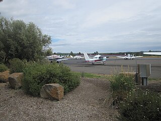
Sunriver Airport is a public use airport located one nautical mile (2 km) west of the central business district of Sunriver, in Deschutes County, Oregon, United States. It is privately owned by Sunriver Resort, L.P. This airport is included in the National Plan of Integrated Airport Systems for 2011–2015, which categorized it as a general aviation facility.
Luther Metke was an American folk poet and early central Oregon pioneer who served in the Spanish–American War. He was the subject of Jorge Preloran's Academy Award-nominated documentary Luther Metke at 94. Metke moved to Central Oregon in 1907 and built nearly every bridge between Bend and Crescent and over 30 log cabins.

Camp Abbot was a military training center in the northwest United States, located in central Oregon south of Bend. Active for less than sixteen months, the U.S. Army camp was used to train combat engineers during World War II and was named for Henry Larcom Abbot.
The Paulina Mountains are a mountain range in Deschutes County, Oregon. There are 97 named mountains in the Paulina Mountains, the tallest and most famous one being Paulina Peak, which sits at 7,969 feet in elevation."Paulina Peak serves as the highest point of the Newberry Volcano, a large active stratovolcano that sits just 35 miles east of the crest of the Cascade Range. These summits are actually the remnants of an old crater called the Newberry Crater.

Crooked River Ranch is an unincorporated community and census-designated place (CDP) in southern Jefferson County, Oregon, United States. A small portion of the ranch is also in north Deschutes County. It is located between the Deschutes River and the Crooked River near the south end of Lake Billy Chinook. It is west of U.S. Route 97 between Culver and Terrebonne. Amenities in the community include a golf course, swimming pool, tennis courts, saloon, disc golf course, horse riding arena and general store. The 12,000-acre (49 km2) ranch has a population of approximately 5,000. It is the largest homeowner association in Oregon. Crooked River Ranch has a Terrebonne mailing address, but the postal service also allows mail addressed to Crooked River, Oregon or Crooked River Ranch, Oregon. The ZIP code is 97760.

Benham Falls are rapids of the Deschutes River located between Sunriver and Bend, Oregon, United States. With a pitch of 22.5°, they are rated Class 5 for watercraft, and are the largest falls on the upper Deschutes.
The 2006 NCAA Division I Men's Golf Championship was a golf tournament contested from May 31 to June 3, 2006 at the Crosswater Club in Sunriver, Oregon. It was the 68th NCAA Division I Men's Golf Championship. The team championship was won by the Oklahoma State Cowboys who captured their tenth national championship by three strokes over the Florida Gators. The individual national championship was won by Jonathan Moore, also from Oklahoma State.
The 2005 NCAA Division I Women's Golf Championships were contested at the 24th annual NCAA-sanctioned golf tournament to determine the individual and team national champions of women's Division I collegiate golf in the United States.