Sunset Terrace/Montclair, Houston

Last updated

Sunset Terrace and Montclair Place are two Inner Loop neighborhoods (neighborhoods within the 610 Loop) of Harris County, Texas, United States. The two subdivisions are served by the Sunset Terrace/Montclair Civic Association.

Contents

Much of Sunset Terrace is in West University Place, [1] while the rest of Sunset Terrace and Montclair are in Houston.

History

A cemetery was once located at the intersection of Auden and Drake in what is now Sunset Terrace. In 1956 the Sunset Terrace Garden Club planted oleanders to beautify a ditch formerly belonging to a Harris County poor farm. [2]

It was created in the late 1940s and annexed by the city shortly thereafter.[ citation needed ]

From January 1990 to October 1991 housing values increased by 21%. In October 1991 the average house price was $102.46 per square foot. A study conducted by the Sage Realty Advisors and the University of Houston Center for Public Policy stated that Sunset Terrace was one of the neighborhoods with the most quickly increasing house prices. [3]

Cityscape

The community is inside the 610 Loop. Together the area that Sunset Terrace and Montclair occupy is bounded by Weslayan Street to the west, Westpark Drive to the north, Edloe Street to the east, and Bissonnet Street to the south. [4] The community is between West University Place and Interstate 69/U.S. Route 59 (Southwest Freeway). [3] It is in proximity to Highland Village, Rice Village, Rice University, and The Galleria. [4]

The community has many mature oak trees. The street names in the community originate from U.S. universities and colleges. The sizes of lots in Sunset Terrace/Montclair are larger than typical properties in West University Place. Several lots are over 10,000 square feet (930 m2) of area. [4] In 1995 Joanne Flynn, a Sunset Terrace resident and a real estate agent with John Daugherty, said "You get a little bit larger lot in Sunset Terrace for the same amount of money. They're deeper than your typical West U. lot." [5] In 2009 Kathleen Dunwoody Graf, a real estate agent with Greenwood King Properties, said that house buyers choose Sunset Terrace mainly due to the central location and large lots. [4]

Houses and multifamily complexes

As of 2009 Sunset Terrace housing prices ranged from $300,000 ($361889.25 inflation-adjusted) to almost $2 million ($2412595.01 inflation-adjusted). [4] The lower priced houses include late 1940s and 1950s one story ranch houses, [5] [4] typically each with three bedrooms and two bedrooms. Each older style house, as of 2009, is priced from $300,000 to $600,000 ($723778.5 inflation-adjusted). By 2009 many of the older houses had been demolished, and newly built stone houses and stucco houses, typically priced up to $2 million, had replaced them. The houses often have stucco siding, summer kitchens, outdoor areas, and large entertainment spaces. In 2009 Dunwoody Graf said that there was an increasing trend of house buyers buying older houses for inexpensive amounts and refurbishing them. [4] In 1995, older houses were priced from $130,000 ($220792.75 inflation-adjusted) to $250,000 ($424601.44 inflation-adjusted) and newer houses were priced at $300,000 ($509521.73 inflation-adjusted) and above. [5]

As of 1995 several multifamily complexes are within Sunset Terrace/Montclair. Some apartments are located along Law Street. Some duplexes are located on the edges of the subdivisions. [5]

Government and infrastructure

In 1986 METRO was proposing an Edloe Street station of its "station busway." Paul Bay, the METRO assistant general manager for transit systems development, said that Sunset Terrace/Montclair residents said that they felt concerns about the visual effects of the proposed station and issues with noise and traffic. [6] The station was never built.

In 1995 the civic club was discussing with the City of Houston the possibility of installing speed bumps. The community had experienced a lot of vehicular traffic going to The Galleria and Greenway Plaza. [5]

In 2006, during a controversy of where to place the METRORail University Line, Kristin Lindquist, the chairperson of the subdivision's rail committee, said that the community was opposed to having the light rail line placed on Westpark from Edloe to the Union Pacific railroad. She added that "We've been brushed off because we're not as rich as Afton Oaks," a Houston community opposed to the placement of the rail line on Richmond. [7] During that year, Tom Valega, a property owner in Sunset Terrace/Montclair quoted in the Houston Chronicle , argued that the light rail should be placed on Richmond Avenue because the light rail can get additional ridership, and the federal funding of the light rail line depends upon ridership figures. [8]

In 2008 Steve Halvorson, a resident of Sunset Terrace, said in a 2008 meeting outside of Houston City Hall that on a yearly basis, after the Tropical Storm Allison in 2001, flooding had occurred in Sunset Terrace. [9]

Harris Health System (formerly Harris County Hospital District) designated Martin Luther King Health Center in southeast Houston for ZIP code 77005. The nearest public hospital is Ben Taub General Hospital in the Texas Medical Center. [10]

Culture

Many Sunset Terrace residents plan neighborhood events. [4]

Education

Primary and secondary schools

Public schools

The Houston Independent School District serves residents of Sunset Terrace.

Before August 1994, [15] a portion of the neighborhood was served by West University Elementary, and a portion was served by Will Rogers Elementary School. Historically West University Elementary had higher test scores than Will Rogers. After The Rice School opened, West U Elementary was relieved of many students, and the West U attendance boundary was modified to include all of Sunset Terrace/Montclair. In 1995 C.T.I. Information Services stated that test scores of the Texas Assessment of Academic Skills (TAAS) test at West U, Pershing, and Lamar were above average. Davis Whiteford, president of the Sunset Terrace/Montclair Civic Association, said that the schools attracted many homebuyers to Sunset Terrace. [5]

Colleges and universities

Houston Community College System serves Sunset Terrace.

Postal services

The closest United States Postal Service office is the Weslayan Post Office at 5340 Weslayan Street, Houston, Texas, 77005-1048.

Media

The Houston Chronicle is the area regional newspaper.

The West University Examiner is a local newspaper distributed in the community .

The Village News and Southwest News is a local newspaper distributed in the community.

Notable residents

Related Research Articles

West University Place, Texas Enclave city in Texas, United States

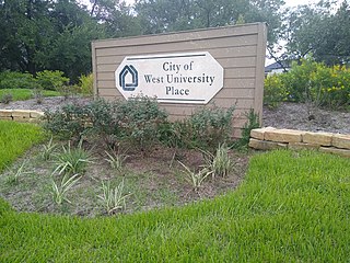
West University Place, often called West University or West U for short, is a city located in the U.S. state of Texas within the Houston–Sugar Land metropolitan area and southwestern Harris County. At the 2010 U.S. census, the population of the city was 14,787. Its population increased to 15,585 in 2019. It is nicknamed "The Neighborhood City" and is mainly a bedroom community for upper-class families.

Sharpstown, Houston

Sharpstown is a master-planned community in the Southwest Management District, Southwest Houston, Texas It was one of the first communities to be built as a master-planned, automobile centered community and the first in Houston. Frank Sharp (1906–1993), the developer of the subdivision, made provisions not only for homes but also for schools, shopping and recreation areas. While this model has been duplicated countless times in the past fifty years, at the time it was quite revolutionary, attracting national media attention. The development was dedicated on March 13, 1955.

Braeswood Place, Houston

Braeswood Place is a group of subdivisions in Harris County, Texas, United States. The vast majority of the land is in Houston while a small part is in Southside Place.

Afton Oaks, Houston

Afton Oaks is a deed-restricted "Inner Loop" upscale residential community of approximately 525 homes in Houston, Texas, United States. Afton Oaks is located inside Interstate 610 near the Galleria and Highland Village. The neighborhood is bounded on the north by Westheimer Road, on the east by Union Pacific railroad tracks, on the south by Interstate 69/U.S. Highway 59, and on the west by Interstate 610.

Southampton, Houston

Southampton Place, also known as Southampton, is a neighborhood located in Houston, Texas. The Southampton Civic Club Inc. is the homeowners' association.

Rice Military, Houston

Rice Military is a neighborhood in Houston, Texas, United States. The Beer Can House is located in Rice Military.

Southgate is a neighborhood in Houston, Texas, United States.

Boulevard Oaks, Houston United States historic place

Boulevard Oaks is a neighborhood in Houston, Texas, United States, containing 21 subdivisions north of Rice University and south of U.S. Highway 59. Developed primarily during the 1920s and 1930s, Boulevard Oaks contains two National Register historic districts, Broadacres and Boulevard Oaks. The Boulevard Oaks Civic Association (BOCA) is the common civic association for all 21 subdivisions.

Poe Elementary School (Houston) United States historic place

Edgar Allan Poe Elementary School is a primary school located at 5100 Hazard Street in Houston, Texas, United States. A part of the Houston Independent School District (HISD), the school, which was built during the 1920s, is located in the Chevy Chase subdivision of the Boulevard Oaks neighborhood west of Rice University. The school, a National Register of Historic Places (NRHP) historic district contributing property of Boulevard Oaks, was named after Edgar Allan Poe.

Oak Forest, Houston

Oak Forest is a large residential community in northwest Houston, Texas, United States. Oak Forest is the third largest group of subdivisions in Harris County.

St. George Place, Houston

St. George Place is a neighborhood in Houston, Texas.

Third Ward, Houston Neighborhood in Houston, Texas

Third Ward is an area of Houston, Texas, United States, that evolved from one of the six historic wards of the same name. It is located in the southeast Houston management district.

Crestwood/Glen Cove is a community in Houston, Texas. It consists of the Crestwood and Glen Cove subdivisions. The Crestwood/Glen Cove Civic Club serves the Crestwood/Glen Cove community.

Morningside Place is a group of subdivisions located in Houston, Texas, United States.

Idylwood, Houston

Idylwood is a historic neighborhood in the southeastern part of the I-610 loop in Houston, Texas. Idylwood, as of 2021, is the most expensive neighborhood in the East End. As of that year its houses were priced between $295,000 and $679,900. It currently has approximately 340 homes. Bill England, a redeveloper in the East End area, stated in 2004 that Idylwood appealed to buyers who are priced out of houses located in the cities of Bellaire and West University Place.

Riverside Terrace is a neighborhood in Houston, Texas, United States. It is along Texas State Highway 288 and north of the Texas Medical Center and located near Texas Southern University and University of Houston. There about 20 sections of Riverside Terrace that span across North and South MacGregor. The community, formerly an affluent Jewish neighborhood, became an affluent community for African Americans in the 1950s and '60s. It is still predominantly African American neighborhood with different income levels. It has been undergoing a gradual change in demographics and aesthetics due to gentrification efforts since the early 2000s.

Shadyside, Houston

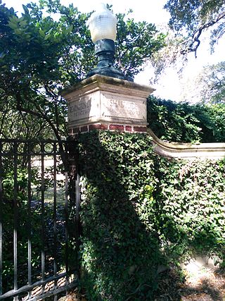
Shadyside is a private, walled subdivision of 16 houses in Houston, Texas. In 2012 Terrence McCoy of the Houston Press said that Shadyside has a "sense of exclusivity, or as Heritage Texas Properties puts it, 'mystique,'" which caused many prominent figures from Houston to settle in Shadyside and continue doing so for a period of almost 100 years.

Scenic Woods, Houston

Scenic Woods is a neighborhood located in northeast Houston, Texas, United States, near Homestead Road and Parker Road. The community is populated by working class African Americans. The community is a quiet family oriented place with manicured lawns and well maintained homes.

Knollwood Village, Houston

Knollwood Village is a subdivision in Houston, Texas. It is managed by the Knollwood Village Civic Club (KVCC), which governs Knollwood Village sections 1-10 and Braes Terrace II.

Sunset Heights is a neighborhood in northern Houston.

References

  1. "Zoning Map." City of West University Place. Retrieved on March 24, 2019.
  2. Lake, Deborah Mann. "Ditch in West U. once served county farm."[ dead link ] Houston Chronicle . Wednesday April 18, 2001. ThisWeek 4. Retrieved on October 17, 2012. Available from the Houston Public Library, accessible with a library card.
  3. 1 2 Bivins, Ralph. "Some homes see 22 percent surge/Prices outside Beltway 8 outpace those inside 610." Houston Chronicle . Sunday October 27, 1991. ThisWeek p. 4. Retrieved on October 17, 2012.
  4. 1 2 3 4 5 6 7 8 Nicholson, Heather. "Sunset Terrace, Montclair Place offer both new, resale homes." Houston Chronicle . Thursday August 20, 2009. Retrieved on October 17, 2012.
  5. 1 2 3 4 5 6 Feser, Katherine. "Neighborhood comparatively a bargain."[ dead link ] Houston Chronicle . Sunday October 1, 1995. Business 8. Retrieved on October 17, 2012. Available from the Houston Public Library newspapers section, accessible with a library card and PIN.
  6. Snyder, Mike. "Metro directors reach agreement on concept for `station busways'." Houston Chronicle . Friday October 17, 1986. A31. Retrieved on October 17, 2012.
  7. Sallee, Rad. "Metro studies limiting rail impact on Richmond." Houston Chronicle . Saturday August 5, 2006. Retrieved on October 17, 2012.
  8. Sallee, Rad. "No accord reached on Richmond light rail route." Houston Chronicle . Wednesday July 26, 2006. Retrieved on October 17, 2012.
  9. Christian, Carol. "Group denied speaking time before Pasadena council." Houston Chronicle . Tuesday March 25, 2008. Retrieved on October 17, 2012.
  10. "Clinic/Emergency/Registration Center Directory By ZIP Code". Harris County Hospital District. 2001-11-19. Archived from the original on 2001-11-19. Retrieved 2021-04-08. - See ZIP code 77005. See this map for relevant ZIP code.
  11. "West University Elementary Attendance Boundary Archived June 17, 2012, at the Wayback Machine ." Houston Independent School District . Retrieved on November 29, 2008.
  12. "Pershing Middle Attendance Boundary Archived April 11, 2008, at the Wayback Machine ." Houston Independent School District . Retrieved on November 29, 2008
  13. "Pin Oak Middle School." The Southwest District. Houston Independent School District. Retrieved on November 29, 2008.
  14. "Lamar High School Attendance Boundary Archived September 28, 2011, at the Wayback Machine ." Houston Independent School District . Retrieved on November 29, 2008.
  15. "History of The Rice School / La Escuela Rice." The Rice School. February 28, 2007. Retrieved on September 8, 2009.
  16. 1 2 Mason, Julie. "Ex-reporter seeks to fill City Council slot / Fifth candidate vies for District C seat." Houston Chronicle . Thursday July 15, 1999. A31. Retrieved on October 17, 2012.
  17. Mason, Julie. "Chimney Rock issue may decide outcome of District C." Houston Chronicle . Sunday September 19, 1999. A35 MetFront. Retrieved on October 17, 2012.
  18. Staff. "FOR YOUNG, ELLIS / Runoff choices for City Council Districts C and F." Houston Chronicle . Sunday November 21, 1999. Outlook p. 2. Retrieved on October 17, 2012.

Further reading