
Estadio Ramón "Tahuichi" Aguilera Costas is a multi-purpose stadium in Santa Cruz, Bolivia. It is used mostly for football matches, on club level by Blooming, Oriente Petrolero, Destroyers, and Royal Pari. The stadium has a capacity of 38,000 people and was built in 1939. It was also one of the official stadiums for the 1997 Copa America as well as a number of international regional tournaments, such as, Copa Libertadores and Copa Sudamericana. Initially, it was known as Estadio William Bendeck, but in 1980 it was renamed after the Bolivian player Ramón Aguilera Costas.

Ocurí is a small town in the Bolivian Potosí Department.
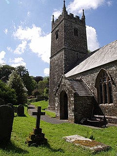
Bradford is a village and civil parish in the local government district of Torridge, Devon, England. The parish, which lies about six miles east of the town of Holsworthy has part of its eastern boundary formed by the River Torridge, and it is surrounded clockwise from the north by the parishes of Milton Damerel, Shebbear, Black Torrington, Ashwater, Cookbury and Thornbury. In 2001 its population was 359, compared to 280 in 1901.

Nor Khachakap is a village in Lori Province, Armenia.

Ignacio Warnes is one of the fifteen provinces of the Bolivian Santa Cruz Department and is situated in the department's central parts. The province name honors Colonel Ignacio Warnes (1772–1816), a military leader in the South American war of independence.

Andrés Ibáñez Province is one of the fifteen provinces of the Bolivian Santa Cruz Department, situated in the western part of the department. Its capital is Santa Cruz de la Sierra which is also the capital of the department.

Highbridge Reservoir received water from a portion of the Croton Aqueduct system. It was located on Amsterdam Avenue between 172nd Street and 174th Street, in Upper Manhattan adjacent to the High Bridge Water Tower and the High Bridge across the Harlem River Valley. The reservoir covered about 7 acres (28,000 m2), was 16 feet (4.9 m) deep, and had a total capacity of 10,794,000 US gallons (40,860,000 L).
Serra do Coqueiro is a mountain range in the border of Brazilian states of Rio Grande do Norte, Ceará and Paraíba. An unnamed peak at Venha-Ver is the highest point in Rio Grande do Norte, reaching 868 metres (2,848 ft).

Adams Station is an unincorporated community in Del Norte County, California. It is located on the Smith River just west of Gasquet, at an elevation of 338 feet.

Robinson is a former settlement in Fresno and Kings Counties, California. It is located on the Southern Pacific Railroad 8 miles (13 km) north-northwest of Lemoore, at an elevation of 226 feet.
The Yapacaní River is a river of Bolivia, part of the Amazon River basin. The 335 kilometres river is a tributary of the Rio Grande. The river runs northwards through the Santa Cruz Department and joins the Mamoré River.

Rumsey is a hamlet in southern Alberta, Canada within Starland County. It is located 8 kilometres (5.0 mi) west of Highway 56, approximately 80 kilometres (50 mi) southeast of Red Deer.

Saint-Quentin is a Canadian parish in Restigouche County, New Brunswick.
Sardis was a community in northern Pushmataha County, Oklahoma, six miles northwest of Clayton.
Todos Santos is a town in Bolivia. It is located in Beni Department, more exactly in Iténez Province near Río Baures river.
Mark Arendz Provincial Ski Park is a provincial park in Prince Edward Island, Canada.

Enterprise is an unincorporated community in Luce Township, Spencer County, in the U.S. state of Indiana.
Choteau Creek is a stream in the U.S. state of South Dakota.
Mangas Springs is a populated place in Grant County, New Mexico named for the springs found at that location. It lies at an elevation of 4,734 feet / 1,443 meters on Mangus Creek a tributary of the Gila River.
Klondike is an unincorporated community in southern St. Charles County, in the U.S. state of Missouri.


