Related Research Articles
The International Hydrographic Organization (IHO) is an intergovernmental organisation representing hydrography. As of January 2022 the IHO comprised 97 Member States.

Hydrography is the branch of applied sciences which deals with the measurement and description of the physical features of oceans, seas, coastal areas, lakes and rivers, as well as with the prediction of their change over time, for the primary purpose of safety of navigation and in support of all other marine activities, including economic development, security and defense, scientific research, and environmental protection.

Echo sounding is a type of sonar used to determine the depth of water by transmitting acoustic waves into water. The time interval between emission and return of a pulse is recorded, which is used to determine the depth of water along with the speed of sound in water at the time. This information is then typically used for navigation purposes or in order to obtain depths for charting purposes. Echo sounding can also refer to hydroacoustic "echo sounders" defined as active sound in water (sonar) used to study fish. Hydroacoustic assessments have traditionally employed mobile surveys from boats to evaluate fish biomass and spatial distributions. Conversely, fixed-location techniques use stationary transducers to monitor passing fish.

Hydrographic survey is the science of measurement and description of features which affect maritime navigation, marine construction, dredging, offshore oil exploration/offshore oil drilling and related activities. Strong emphasis is placed on soundings, shorelines, tides, currents, seabed and submerged obstructions that relate to the previously mentioned activities. The term hydrography is used synonymously to describe maritime cartography, which in the final stages of the hydrographic process uses the raw data collected through hydrographic survey into information usable by the end user.

The Canadian Hydrographic Service (CHS) is part of the federal department of Fisheries and Oceans Canada and is Canada's authoritative hydrographic office. The CHS represents Canada in the International Hydrographic Organization (IHO).
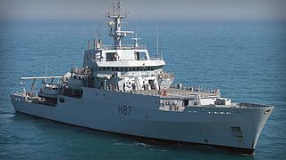
The Echo class is a class of multi-purpose hydrographic survey ships in commission with the Royal Navy. The ships are primarily tasked with conducting survey work in support of submarine and amphibious operations, however, the class also has a secondary role in mine countermeasures. The two vessels of the class are the most recent additions to the Royal Navy's Hydrographic Squadron. Each ship displaces approximately 3,700 tonnes, and is equipped with a state of the art suite of equipment.
The United Kingdom Hydrographic Office (UKHO) is the UK's agency for providing hydrographic and marine geospatial data to mariners and maritime organisations across the world. The UKHO is a trading fund of the Ministry of Defence (MoD) and is located in Taunton, Somerset, with a workforce of approximately 900 staff.

A research vessel is a ship or boat designed, modified, or equipped to carry out research at sea. Research vessels carry out a number of roles. Some of these roles can be combined into a single vessel but others require a dedicated vessel. Due to the demanding nature of the work, research vessels are often constructed around an icebreaker hull, allowing them to operate in polar waters.

Admiralty charts are nautical charts issued by the United Kingdom Hydrographic Office (UKHO) and subject to Crown Copyright. Over 3,500 Standard Nautical Charts (SNCs) and 14,000 Electronic Navigational Charts (ENCs) are available with the Admiralty portfolio offering the widest official coverage of international shipping routes and ports, in varying detail.
The Naval Oceanographic Office (NAVOCEANO), located at John C. Stennis Space Center in south Mississippi, comprises approximately 1,000 civilian, military and contract personnel responsible for providing oceanographic products and services to all elements within the Department of Defense.

CSS Acadia is a former hydrographic surveying and oceanographic research ship of the Hydrographic Survey of Canada and its successor the Canadian Hydrographic Service.
The Australian Hydrographic Service is the Australian Commonwealth Government agency responsible for providing hydrographic services that meet Australia's obligations under the SOLAS convention and the national interest; enabling safe navigation, maritime trade and supporting protection of the marine environment. The agency, headquartered at the Australian Hydrographic Office in Wollongong, New South Wales, is an element of the Royal Australian Navy (RAN), and serves both military and civilian functions. The names Australian Hydrographic Service and the Australian Hydrographic Office are commonly abbreviated as AHS or AHO respectively.
Offshore survey is a specific discipline of hydrographic survey primarily concerned with the description of the condition of the seabed and the condition of the subsea oilfield infrastructure that interacts with it.

The Taymyr was an icebreaking steamer of 1200 tons built for the Russian Imperial Navy at St. Petersburg in 1909. It was named after the Taymyr Peninsula.
The Ginger Islands are a group of islands lying west of Cape Alexandra, off the southern end of Adelaide Island, Antarctica. The largest of the islands appears reddish when free of snow. They were surveyed by the Royal Navy's hydrographic survey unit in 1962-63 and named by the United Kingdom Antarctic Place-Names Committee (UK-APC) for Kenneth Ginger, Civil Hydrographic Officer responsible for British Admiralty charts of the Antarctic for several years beginning in 1958.
The United States Hydrographic Office prepared and published maps, charts, and nautical books required in navigation. The office was established by an act of 21 June 1866 as part of the Bureau of Navigation, Department of the Navy. It was transferred to the Department of Defense on 10 August 1949. The office was abolished on 10 July 1962, replaced by the Naval Oceanographic Office.
The Bathurst Channel is a narrow offshore stretch of water that links Port Davey with Bathurst Harbour in the South West region of Tasmania, Australia. The Bathurst Channel is contained within the Port Davey/Bathurst Harbour Marine Nature Reserve, and the Southwest National Park, part of the Tasmanian Wilderness World Heritage Area.

The Laser Airborne Depth Sounder (LADS) Flight was a unit of the Royal Australian Navy. Unlike the rest of the flying units of the RAN, it was not controlled by the Fleet Air Arm from HMAS Albatross, but instead fell under the operational control of the Australian Hydrographic Service at HMAS Cairns, providing a platform for the operation of the laser airborne depth sounder system.

The Russian Hydrographic Service, full current official name Department of Navigation and Oceanography of the Ministry of Defence of the Russian Federation, is Russia's hydrographic office, with responsibility to facilitate navigation, performing hydrographic surveys and publishing nautical charts.
References
| | This article about a type of ship or boat is a stub. You can help Wikipedia by expanding it. |