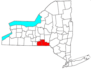
Harrisburg is the capital city of the Commonwealth of Pennsylvania in the United States, and the county seat of Dauphin County. With a population of 49,192, it is the 15th largest city in the Commonwealth. It lies on the east bank of the Susquehanna River, 107 miles (172 km) west of Philadelphia. Harrisburg is the anchor of the Susquehanna Valley metropolitan area, which had a 2017 estimated population of 571,903, making it the fourth most populous in Pennsylvania and 96th most populous in the United States.

York County is a county in the U.S. state of Pennsylvania. As of the 2010 census, the population was 434,972. Its county seat is York. The county was created on August 19, 1749, from part of Lancaster County and named either after the Duke of York, an early patron of the Penn family, or for the city and shire of York in England.

Susquehanna County is a county located in the U.S. state of Pennsylvania. As of the 2010 census, the population was 43,356. Its county seat is Montrose. The county was created on February 21, 1810, from part of Luzerne County and later organized in 1812. It is named for the Susquehanna River.

Snyder County is a county in the U.S. state of Pennsylvania. As of the 2010 census, the population was 39,702. The county seat is Middleburg. Snyder County was formed in 1855 from parts of Union County.

Montour County is a county located in the U.S. state of Pennsylvania. As of the 2010 census, the population was 18,267. Its county seat is Danville. The county is named for Andrew Montour, a prominent Métis interpreter who served with George Washington during the French and Indian War. It encompasses 132 sq mi, making it the smallest county by land area in the state.

Lycoming County is a county located in the U.S. Commonwealth of Pennsylvania. As of the 2010 census, the population was 116,111. Its county seat is Williamsport.
Dauphin County is a county in the U.S. state of Pennsylvania. As of the 2010 census, the population was 268,100. The county seat and the largest city is Harrisburg, Pennsylvania's state capital and tenth largest city. The county was created ("erected") on March 4, 1785, from part of Lancaster County and was named after Louis-Joseph, Dauphin of France, the first son of king Louis XVI.

Waverly is the largest village in Tioga County, New York, United States. It is located southeast of Elmira in the Southern Tier region. This village was incorporated as the southwest part of the town of Barton in 1854. The village name is attributed to Joseph "Uncle Joe" Hallett, founder of its first Fire Department and pillar of the community, who conceived the name by dropping the 2nd "e" from the name of his favorite author's novel, Waverley by Sir Walter Scott. The former village hall is listed on the National Historic Places list.

Loyalsock Township is a township in Lycoming County, Pennsylvania, United States. The population was 11,026 at the 2010 census. It is part of the Williamsport, Pennsylvania Metropolitan Statistical Area. It is the second largest municipality in Lycoming County in terms of population behind the county seat Williamsport.

Williamsport is a city in, and the county seat of, Lycoming County, Pennsylvania, United States. In 2017, the population was estimated at 28,462. It is the principal city of the Williamsport, Pennsylvania Metropolitan Statistical Area, which has a population of about 114,000.

The Susquehanna River is a major river located in the northeastern and mid-Atlantic United States. At 464 miles (747 km) long, it is the longest river on the East Coast of the United States that drains into the Atlantic Ocean. With its watershed, it is the 16th-largest river in the United States, and the longest river in the early 21st-century continental United States without commercial boat traffic.

The West Branch Susquehanna River is one of the two principal branches, along with the North Branch, of the Susquehanna River in the northeastern United States. The North Branch, which rises in upstate New York, is generally regarded as the extension of the main branch, with the shorter West Branch being its principal tributary. The West Branch, which is 243 miles (391 km) long, is entirely within the state of Pennsylvania, draining a large mountainous area within the Allegheny Plateau in the western part of the state. Along most of its course it meanders along mountain ridges and through water gaps, forming a large zigzag arc through central Pennsylvania around the north end of the Allegheny Ridge. In colonial times the river provided an important water route to the Ohio River valley. In the 18th century, its lower valley became a significant industrial heartland of Pennsylvania. In the 20th century, the upper reaches of the West Branch turned a yellow/orange color due to sulfurous drainage from nearby and abandoned deep bituminous coal mines.

The Cumberland Valley is a northern constituent valley of the Great Appalachian Valley, within the Atlantic Seaboard watershed in Pennsylvania and Maryland. The Appalachian Trail crosses through the valley.

The Wyoming Valley is a historic industrialized region of Northeastern Pennsylvania, once famous for fueling the industrial revolution in the United States with its many anthracite coal mines. As a metropolitan area, it is known as the Scranton/Wilkes-Barre metropolitan area, after its principal cities, Scranton and Wilkes-Barre, and is the 97th-largest metropolitan area in the United States and the 4th largest in Pennsylvania. It makes up its own unique physiographic province, the Anthracite Valley, in the geology of Pennsylvania. Greater Pittston makes up the center of the valley. Scranton is the most populated city in the metropolitan area with a population of 77,114. The city of Scranton has grown in population after the 2015 mid term census while Wilkes-Barre has declined in population. Wilkes-Barre is still the second most populated city in the metropolitan area and Hazleton is third. The airports for this area are Wilkes-Barre/Scranton International Airport (Avoca) and the Wilkes-Barre Wyoming Valley Airport.
Northeastern Pennsylvania (NEPA) is a geographic region of the U.S. state of Pennsylvania that includes the Pocono Mountains, the Endless Mountains, and the industrial cities of Scranton, Wilkes-Barre, Pittston, Hazleton, Nanticoke, and Carbondale. A portion of this region constitutes a part of the New York City metropolitan area.

Blue Mountain Ridge, Blue Mountain, or the Blue Mountains of Pennsylvania is part of the geophysical makeup of the Ridge-and-Valley Appalachians in the U.S. state of Pennsylvania. It is a ridge that forms the southern and eastern edge of the Appalachian mountain range spanning over 255 miles (410 km) from the Delaware Water Gap as it cuts across the eastern half of the state on a slight diagonal from New Jersey tending southerly until it turns southerly curving into Maryland, and beyond.
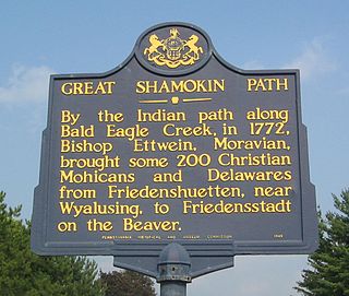
The Great Shamokin Path was a major Native American trail in the U.S. State of Pennsylvania that ran from the native village of Shamokin along the left bank of the West Branch Susquehanna River north and then west to the Great Island. There it left the river and continued further west to Chinklacamoose and finally Kittanning on the Allegheny River.
Geographic regions of the Commonwealth of Pennsylvania, United States of America.
The Lackawanna Heritage Valley National and State Heritage Area is a state and federally designated National Heritage Area in northeastern Pennsylvania. It was initially established in 1991 as the first State Heritage Park in Pennsylvania, and was additionally designated a National Heritage Area in 2000. The designations recognize the area's heritage of industry, architecture, history and natural resources, and provide a framework for development and promotion of these features. The Lackawanna Heritage Valley National and State Heritage Area is managed by the Lackawanna Heritage Valley Authority, or LHVA.

North Central Pennsylvania, parts of which are sometimes referred to as the Northern Tier, is a region in the U.S. state of Pennsylvania which consists of sixteen counties.