
The Euphrates is the longest and one of the most historically important rivers of Western Asia. Together with the Tigris, it is one of the two defining rivers of Mesopotamia. Originating in Turkey, the Euphrates flows through Syria and Iraq to join the Tigris in the Shatt al-Arab in Iraq, which empties into the Persian Gulf.

Transport in Turkey is road-dominated and mostly fuelled by diesel. Transport consumes a quarter of energy in Turkey, and is a major source of air pollution in Turkey and greenhouse gas emissions by Turkey. The World Health Organization has called for more active transport such as cycling. As of 2023 health impact assessment is not done in Turkey.
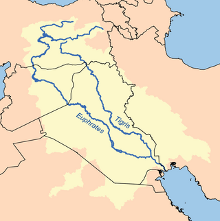
The Tigris is the eastern of the two great rivers that define Mesopotamia, the other being the Euphrates. The river flows south from the mountains of the Armenian Highlands through the Syrian and Arabian Deserts, before merging with the Euphrates and reaching to the Persian Gulf.
The Atatürk Dam, originally the Karababa Dam, is the third largest dam in the world and it is a zoned rock-fill dam with a central core on the Euphrates River on the border of Adıyaman Province and Şanlıurfa Province in the Southeastern Anatolia Region of Turkey. Built both to generate electricity and to irrigate the plains in the region, it was renamed in honour of Mustafa Kemal Atatürk (1881–1938), the founder of the Turkish Republic. The construction began in 1983 and was completed in 1990. The dam and the hydroelectric power plant, which went into service after the upfilling of the reservoir was completed in 1992, are operated by the State Hydraulic Works (DSİ). The reservoir created behind the dam, called Atatürk Reservoir, is the third largest in Turkey.

The Tabqa Dam, or al-Thawra Dam as it is also named, most commonly known as Euphrates Dam, is an earthen dam on the Euphrates, located 40 kilometres (25 mi) upstream from the city of Raqqa in Raqqa Governorate, Syria. The city of Al-Thawrah is located immediately south of the dam. The dam is 60 metres (200 ft) high and 4.5 kilometres (2.8 mi) long and is the largest dam in Syria. Its construction led to the creation of Lake Assad, Syria's largest water reservoir. The dam was constructed between 1968 and 1973 with help from the Soviet Union. At the same time, an international effort was made to excavate and document as many archaeological remains as possible in the area of the future lake before they would be flooded by the rising water. When the flow of the Euphrates was reduced in 1974 to fill the lake behind the dam, a dispute broke out between Syria and Iraq that was settled by intervention from Saudi Arabia and the Soviet Union. The dam was originally built to generate hydroelectric power, as well as irrigate lands on both sides of the Euphrates. The dam has not reached its full potential in either of these objectives.

The Ilısu Dam is a concrete-face rock-fill dam on the Tigris near the village of Ilısu and along the border of Mardin and Şırnak Provinces in Turkey. It is one of the 22 dams of the Southeastern Anatolia Project and its purpose is hydroelectric power production, flood control and water storage. When operational, the dam will support a 1,200 MW power station and will form a 10.4 billion m3 reservoir. Construction of the dam began in 2006 and was originally expected to be completed by 2016. As part of the project, the much smaller Cizre Dam is to be constructed downstream for irrigation and power. The dam has drawn international controversy, because it will flood portions of ancient Hasankeyf and necessitate the relocation of people living in the region. Because of this, the dam lost international funding in 2008. Most historical structures in Hasankeyf were moved to the new Hasankeyf prior to the filling of the dam. The dam began to fill its reservoir in late July 2019. Due to rainfall, the dam has achieved water levels up to 100m above the river bed and stored 5 billion cubic meters of water. The water level had reached an elevation of 498.2m on 1 April 2020.

Syria, officially the Syrian Arab Republic, is a country in West Asia located in the Eastern Mediterranean and the Levant. It borders the Mediterranean Sea to the west, Turkey to the north, Iraq to the east and southeast, Jordan to the south, and Israel and Lebanon to the southwest. It is a republic under a transitional government and comprises 14 governorates. Damascus is the capital and largest city. With a population of 25 million across an area of 185,180 square kilometres (71,500 sq mi), it is the 57th-most populous and 87th-largest country.

Iran–Turkey relations are the bilateral relations between the Islamic Republic of Iran and the Republic of Turkey. The two states' relationship is complex and characterized by periods of both tension and cooperation, as both Iran and Turkey are fighting for influence in the Middle East through supporting opposing proxies as part of a proxy conflict. The two countries are also major trade partners and are perceived as mutually interdependent due to geographical proximity as well as historically shared cultural, linguistic, and ethnic traits.
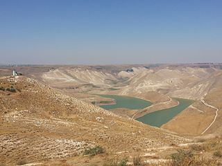
The Al-Wehda Dam, formerly known as Maqarin Dam, is a 110 m (360 ft) roller-compacted concrete gravity dam on the Yarmouk River on the border between Syria and Jordan. It can hold up to 115,000,000 m3 (93,000 acre⋅ft) water and is designed to provide Jordan with water for both human consumption and agriculture. Water from the reservoir is diverted through a diversion weir at Addassiyah downstream of the Al-Wehda dam to the King Abdullah Canal where it is mixed with other freshwater sources. Some of the water from the canal is then pumped to Amman to be used as drinking water, after being treated in the Zai water treatment plant. The discharge of effluents from adjacent agricultural lands has caused algae growth and eutrophication especially in spring. Construction was funded by the Arab Fund for Economic and Social Development (80%), the Abu Dhabi Development Fund (10%) and the Government of Jordan (10%). In February 2004 King Abdullah II of Jordan and Syrian President Bashar al-Assad launched the construction of the dam. Turkey's Ozaltin Company constructed 60 per cent of the dam, while the remaining 40 per cent were carried out by Marwan Alkurdi Company and the National Company for Roads and Bridges.

The Syrian civil war is an ongoing multi-sided conflict in Syria involving various state-sponsored and non-state actors. In March 2011, popular discontent with the Ba'athist regime ruled by Bashar al-Assad triggered large-scale protests and pro-democracy rallies across Syria, as part of the wider Arab Spring protests in the region. After months of crackdown by the government's security apparatus, various armed rebel groups such as the Free Syrian Army began forming across the country, marking the beginning of the Syrian insurgency. By mid-2012, the Syrian Revolution escalated into a full-blown civil war.

The Free Syrian Army is a big-tent coalition of decentralized Syrian opposition rebel groups in the Syrian civil war founded on 29 July 2011 by Colonel Riad al-Asaad and six officers who defected from the Syrian Armed Forces. The officers announced that the immediate priority of the Free Syrian Army was to safeguard the lives of protestors and civilians from the deadly crackdown by Bashar al-Assad's security apparatus; with the ultimate goal of accomplishing the objectives of the Syrian revolution, namely, the end to the decades-long reign of the ruling al-Assad family. In late 2011, the FSA was the main Syrian military defectors group. Initially a formal military organization at its founding, its original command structure dissipated by 2016, and the FSA identity was later used by several different Syrian opposition groups.
This is a broad timeline of the course of major events of the Syrian civil war. It only includes major territorial changes and attacks and does not include every event.

The September 2011 – March 2012 Idlib Governorate clashes were the violent incidents that took place in Idlib Governorate, a province of Syria, from September 2011 and prior to the April 2012 Idlib Governorate Operation.

The Bab al-Hawa Border Crossing is located on the Syria–Turkey border about 50 km (31 mi) west of Aleppo in northwest Syria. It connects the Syrian M45 and the Turkish D827 highways, between the cities of İskenderun and Idlib, and is known for its long lines of trucks and buses. The closest town on the Turkish side of the border is Reyhanlı in Hatay Province, and the closest towns on the Syrian side are ad-Dana and Atarib. The crossing is the site of a 6th-century triumphal arch. It has been an important crossing for Syrian rebels during the Syrian civil war.
The Rojava–Islamist conflict, a major theater in the Syrian civil war, started after fighting erupted between the Kurdish People's Protection Units (YPG) and Islamist rebel factions in the city of Ras al-Ayn. Kurdish forces launched a campaign in an attempt to take control of the Islamist-controlled areas in the governorate of al-Hasakah and some parts of Raqqa and Aleppo governorates after al-Qaeda in Syria used those areas to attack the YPG. The Kurdish groups and their allies' goal was also to capture Kurdish areas from the Arab Islamist rebels and strengthen the autonomy of the region of Rojava. The Syrian Democratic Forces would go on to take substantial territory from Islamist groups, in particular the Islamic State (IS), provoking Turkish involvement in the Syrian Civil War.

The border between the Syrian Arab Republic and the Republic of Turkey is 909 kilometres (565 mi) long, and runs from the Mediterranean Sea in the west to the tripoint with Iraq in the east. It runs across Upper Mesopotamia for some 400 kilometres (250 mi), crossing the Euphrates and reaching as far as the Tigris. Much of the border follows the Southern Turkish stretch of the Baghdad Railway, roughly along the 37th parallel between the 37th and 42nd eastern meridians. In the west, it almost surrounds the Turkish Hatay Province, partly following the course of the Orontes River and reaching the Mediterranean coast at the foot of Jebel Aqra.

The Syrian Democratic Forces (SDF) is a Kurdish-led coalition of U.S.-backed left-wing ethnic militias and rebel groups, and serves as the official military wing of the Autonomous Administration of North and East Syria. The SDF is allied to and supplied by the United States–led CJTF–OIR international alliance. Founded on 10 October 2015, the SDF claims that its mission is fighting to create a secular, democratic and federalized Syria. The SDF is opposed by Turkey who view the group as an extension of the Kurdistan Workers' Party (PKK), which it has designated a terrorist group.

The Rojava conflict, also known as the Rojava Revolution, is a political upheaval and military conflict taking place in northern Syria, known among Kurds as Western Kurdistan or Rojava.

The Raqqa campaign was a military operation launched in November 2016 during the Rojava–Islamist conflict by the Syrian Democratic Forces (SDF) against the Islamic State of Iraq and the Levant (ISIL) in the Raqqa Governorate, with the goal of isolating and eventually capturing the Islamic State's capital city, Raqqa. The SDF's subsidiary goals included capturing the Tabqa Dam, the nearby city of al-Thawrah, and the Baath Dam further downstream. The campaign ended successfully in October 2017, with the capture of Raqqa.
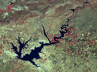
The Atatürk Reservoir is a reservoir on the Euphrates, created by the Atatürk Dam in Turkey. It is located between Adıyaman, Şanlıurfa, and Diyarbakır provinces. The reservoir has a surface area of 817 km² and a volume of 48.5 cubic kilometers, making it the third largest lake in the country after Lake Van and Lake Tuz. It was formed between 1990–1992. The reservoir water level touched 535 m (1,755 ft) amsl in 1994. Since then, it varies between 526 and 537 m amsl. The full reservoir level is 542 m (1,778 ft), and the minimum operation level is 526 m (1,726 ft) amsl.
