Related Research Articles

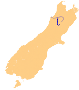
The Buller River is a river in the South Island of New Zealand. The Buller has the highest flow of any river in the country during floods, though it is only the 13th longest river; it runs for 177 km (110 mi) from Lake Rotoiti through the Buller Gorge and into the Tasman Sea near the town of Westport. A saddle at 710 m (2,330 ft) separates the Buller from the Motupiko River and that is divided from the Wairau River by a 695 m (2,280 ft) saddle, both aligned along the Alpine Fault, as is the top of the Buller valley.

The Sabine River is in the South Island of New Zealand. It is located in Nelson Lakes National Park.

Nelson Lakes National Park is in the South Island of New Zealand, at the northern end of the Southern Alps. It was formed after the passing of the National Parks Act in 1952. It was created in 1956. The park contains beech forests, multiple lakes, snow-covered mountains and valleys created by glaciers during the ice ages.
The D'Urville River is in the South Island of New Zealand.
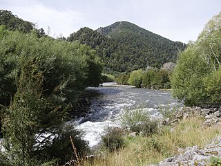
Te Kauparenui / Gowan River is in the South Island of New Zealand. Its source is at Lake Rotoroa and travels 11 kilometres before feeding into the Buller River. Mixed farming and forestry occurs on both banks of the river. The river has introduced trout which attracts recreational fishing.

The Mangles River is in the South Island of New Zealand. Its main tributary is the Tūtaki River but it is also fed by water flowing off the Braeburn Range. It feeds into the Buller River near the town of Murchison. The river is popular destination for kayaking and trout fishing.
Rotoroa is a small settlement at the north western end of Lake Rotoroa in the South Island of New Zealand. Rotoroa is located in the Tasman Region.
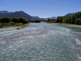
The Maruia River is located in the northwestern South Island of New Zealand. It is a major tributary of the Buller River, flowing for 80 km before joining the larger river eight kilometres to the west of Murchison.

The Matiri River is a river located in the northwest of New Zealand's South Island. The river is in the Tasman Region.
The Mātakitaki River is located in the north of New Zealand's South Island. An upper tributary of the Buller River, it flows north and west for 65 kilometres from its source north of the Lewis Pass, joining the Buller at Murchison. It has one major tributary, the Glenroy River.

Tapawera is a small town in the Tasman District of New Zealand's South Island. It is located 76 km southwest of Nelson and 48 km southeast of Motueka. It is situated on the Motueka Valley Highway by the banks of the Motueka River.

Saint Arnaud is a small alpine village in the Tasman district of New Zealand's South Island, west of the mountains of the Saint Arnaud Range and 90 kilometres southwest of Nelson near the historic Tophouse Settlement. It is situated at the northern end of Lake Rotoiti.

State Highway 6 is a major New Zealand state highway. It extends from the Marlborough region in the northeastern corner of the South Island across the top of the island, then down the length of the island, initially along the West Coast and then across the Southern Alps through inland Otago and finally across the Southland Plains to the island's south coast. Distances are measured from north to south.
The Deepdale River is a river of New Zealand located in the Tasman Region of the South Island.
The Hinemoatū / Howard River is a river of the northern South Island of New Zealand. A tributary of the Buller River, the Hinemoatū/Howard starts at the confluence of the Hodgson and Tier Streams in the Travers Range of Nelson Lakes National Park, flowing north between Lakes Rotoroa and Rotoiti, before reaching the Buller between Kawatiri and Saint Arnaud. Close to its confluence with the Buller, the river is bridged by State Highway 63 and further up by Howard Valley Road.
The Pahau River or Pahu River is a river of the north Canterbury region of New Zealand's South Island. It has its origins in the Tekoa Range, 25 kilometres (16 mi) northwest of Culverden, and flows initially north before turning south to flow down a long valley between two ridges. At the northern edge of the Canterbury Plains it turns southeast, flowing past the southern outskirts of Culverden to reach the Hurunui River 8 kilometres (5 mi) southeast of the town.
The Tiraumea River is a river of the Tasman Region of New Zealand's South Island. The river has its source on the slopes of Mount Hutton at the southern end of the Braeburn Range, and runs northwest from the Tiraumea Saddle. It reaches the Tutaki River 10 kilometres southeast of Murchison. The area is known for hunting.

The Braeburn Range is a mountain range in the Tasman Region of New Zealand's South Island. It lies to the west of Lake Rotoroa and much of the eastern flank of the range is within the Nelson Lakes National Park. The range runs south-southeast, with a westwards curve at the northern end and several westward-trending spurs.

Lake Tennyson is a glacial high-country lake in Canterbury, New Zealand. The first European settler to see the lake was Frederick Weld in 1853, who also named it. The headwaters of the Waiau Toa / Clarence River are just to the north, and the river flows through Lake Tennyson.
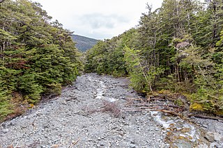
The Blackwater River in Tasman flows due north along a long straight valley, parallel to and equidistant from, the Mātakitaki and Tutaki Rivers, reaching the Mangles River just to the east of the town of Murchison. It is some 20 kilometres (12 mi) in length.
References
"Place name detail: Tutaki River". New Zealand Gazetteer. New Zealand Geographic Board . Retrieved 12 July 2009.
41°50′S172°28′E / 41.833°S 172.467°E