
Carrabelle is a city in Franklin County along Florida's Panhandle, United States. The population was 2,778 as of the 2010 census. Carrabelle is located east of Apalachicola at the mouth of the Carrabelle River on the Gulf of Mexico.

St. Marks is a city in Wakulla County, Florida, United States. It is part of the Tallahassee metropolitan area. The population was 293 at the 2010 census. As of 2018, the population estimated by the U.S. Census Bureau is 319.
U.S. Route 319 is a spur of U.S. Route 19. It runs for 303 miles (488 km) from the foot of the John Gorrie Memorial Bridge across from downtown Apalachicola, Florida to US 1/SR 4 in Wadley, Georgia, through the Panhandle of Florida and the southern portion of Georgia.

The Florida Panhandle is the northwestern part of the U.S. state of Florida; it is a strip of land roughly 200 miles (320 km) long and 50 to 100 miles wide, lying between Alabama on the north and the west, Georgia on the north, and the Gulf of Mexico to the south. Its eastern boundary is arbitrarily defined. In terms of population, major communities include Tallahassee, Pensacola, and Navarre.

The Carrabelle, Tallahassee & Georgia Railroad was a shortline railroad running in north Florida and southern Georgia.
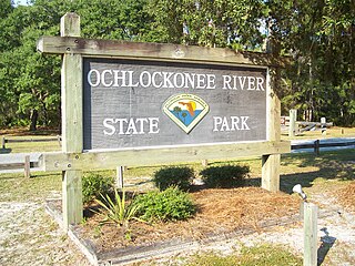
Ochlockonee River State Park is a Florida State Park located in Wakulla County, Florida, south of the town of Sopchoppy in the Florida Panhandle. Located off of U.S. 319 on the Ochlockonee River, just north of the Gulf of Mexico coast, it is surrounded by the Apalachicola National Forest and the St. Marks National Wildlife Refuge and provides important habitat for the endangered red-cockaded woodpecker.

St. George Island is an island and Census-designated place (CDP) off the Florida Panhandle in the northern Gulf of Mexico. It is in Franklin County, Florida, United States.

The Conecuh National Forest in southern Alabama covers 83,000 acres (340 km2), along the Alabama - Florida line in Covington and Escambia counties. Topography is level to moderately sloping, broad ridges with stream terraces and broad floodplains.

The Apalachicola National Forest is the largest U.S. National Forest in the state of Florida. It encompasses 632,890 acres and is the only national forest located in the Florida Panhandle. The National Forest provides water and land-based outdoors activities such as off-road biking, hiking, swimming, boating, hunting, fishing, horse-back riding, and off-road ATV usage.

Worthington State Forest is a state forest located within the Delaware Water Gap National Recreation Area, just above the water gap, in Warren County, New Jersey. It covers an area of 6,660 acres (27.0 km2) and stretches for more than 7 miles (11 km) along the Kittatinny Ridge near Columbia. The park offers hiking, camping and canoeing and kayaking on the Delaware. There are some twenty miles of hiking trails within the park, including seven miles of the Appalachian Trail, which passes through the park. The park is operated and maintained by the New Jersey Division of Parks and Forestry.

Osceola National Forest is a National Forest located in northeast Florida.

Tate's Hell State Forest is 202,000 acres (819 km²) of land in Franklin and Liberty counties in Florida. The forest is located near Carrabelle off US 98 along the Gulf coast and on St. James Island. At one time, Tate's Hell supported at least 12 major habitats including: wet flatwoods, wet prairie, seepage slope, baygall, floodplain forest, floodplain swamp, basin swamp, upland hardwood forest, sandhill, pine ridges, dense titi swamp thickets and scrub. Tate's Hell State Forest is an important hydrologic area and includes a section of the New River. The park's watershed provides fresh water into the Apalachicola Bay, the Carrabelle River and the Ochlockonee River.
Cape St. George Island is an uninhabited barrier island situated on Florida's North Gulf Coast, south-southeast of St. Vincent Island, west of St. George Island and 8–10 miles south-southwest of the town of Apalachicola in Franklin County, Florida. It was formerly part of St. George Island, but was separated from the main island in 1954, when the U.S. Army Corps of Engineers constructed the ship channel known as Bob Sikes Cut.
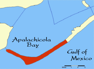
The Forgotten Coast refers to a largely untouched and uninhabited area of coastline in the panhandle of the US state of Florida. The term, also a trademark, was first used in 1992, but the Forgotten Coast's exact location is not agreed upon.
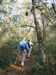
The Florida Trail is one of eleven National Scenic Trails in the United States. It currently runs 1,000 miles (1,600 km), with 300 miles (480 km) planned, from Big Cypress National Preserve to Fort Pickens at Gulf Islands National Seashore, Pensacola Beach. Also known as the Florida National Scenic Trail, the Florida Trail provides permanent non-motorized recreation opportunity for hiking and other compatible activities and is within an hour of most Floridians. The Florida National Scenic Trail is designated as a National Scenic Trail by the National Trails System Act of 1968.
The McKissack Ponds are five small ponds in the city limits of Carrabelle, Franklin County, Florida, just west – 0.3 miles (0.48 km) to 0.8 miles (1.3 km) – of the Carrabelle–Thompson Airport, on the north and south sides of Airport Road. The McKissack Ponds are owned by Franklin County.
The Bainbridge Subdivision is a railroad line owned by CSX Transportation in Georgia. The line runs from Bainbridge south to Attapulgus for a total of 13.3 miles. At its north end it continues south from the Georgia Southwestern Railroad and connects with CSX's Dothan Subdivision and at its south end it connects to the Florida Gulf & Atlantic Railroad's Bainbridge Subdivision, which continues south to Tallahassee, Florida.

The Georgia, Florida and Alabama Railroad, known as the Sumatra Leaf Route, and colloquially as the Gopher, Frog & Alligator was a 180 miles (290 km)-long railroad from Richland, Georgia to Carrabelle, Florida. It was founded in 1895 as a logging railroad, the Georgia Pine Railway.
The Florida Gulf & Atlantic Railroad is a Class III railroad owned and operated by RailUSA in the Florida Panhandle. The line consists of 373 miles of track running from Baldwin, Florida west through Tallahassee to Pensacola. The line also has a short branch from Tallahassee north to Attapulgus, Georgia. The line connects to CSX lines in Baldwin, Pensacola, and Attapulgus.
