
The Aleuts, who are usually known in the Aleut language by the endonyms Unangan, Unangas, Унаӈан, are the indigenous people of the Aleutian Islands.
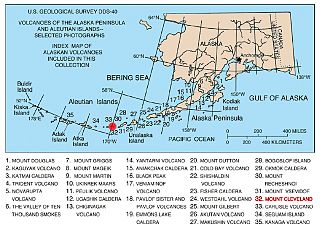
The Aleutian Range is a major mountain range located in southwest Alaska. It extends from Chakachamna Lake to Unimak Island, which is at the tip of the Alaska Peninsula. It includes all of the mountains of the Peninsula. The Aleutian Range is special because of its large number of active volcanoes, which are also part of the larger Aleutian Arc. The mainland part of the range is about 600 miles (1000 km) long. The Aleutian Islands are (geologically) a partially submerged western extension of the range that stretches for another 1,600 km (1000 mi). However the official designation "Aleutian Range" includes only the mainland peaks and the peaks on Unimak Island. The range is almost entirely roadless wilderness. Katmai National Park and Preserve, a large national park within the range, must be reached by boat or plane.

The Andreanof Islands are a group of islands in the Aleutian Islands in southwestern Alaska. They are located at about 52° North and 172°57' to 179°09' West.

The Delarof Islands are a group of small islands at the extreme western end of the Andreanof Islands group in the central Aleutian Islands, Alaska. The Delarofs consist of 11 named islands: Amatignak, Gareloi, Ilak, Kavalga (Qavalĝa), Ogliuga (Aglaga), Skagul (Sxaĝulax̂), the Tag (Tagachaluĝis), Tanadak (Tanaadax̂), Ugidak (Qagan-tanax̂), Ulak, and Unalga (Unalĝa).

Tanaga is a 5,924-foot (1,806 m) stratovolcano in the Aleutian Range of the U.S. state of Alaska. There have been three known eruptions since 1763. The most recent was in 1914 and produced lava flows. It sits west of another stratovolcano known as Mount Takawangha, which last erupted in 1550.
Gareloi or Anangusook is a volcanic island in the Delarof Islands of the Aleutian Islands of Alaska. It is located between the Tanaga Pass and the Amchitka Pass.
Kagalaska Island is an island in the Andreanof Islands of the Aleutian Islands of Alaska.
Little Tanaga Island is an island located in the Andreanof Islands of the Aleutian Islands of Alaska. It lies between Kagalaska Island and Umak Island. The island is 12.5 kilometres (7.8 mi) long and 16.3 kilometres (10.1 mi) wide.

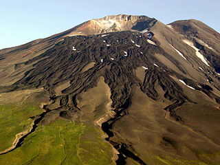
Bobrof Island is one of the Andreanof Islands subgroup of the Aleutian Islands in southwestern Alaska, United States. Bobrof Island is a small, uninhabited island about 9 miles (14 km) north and west of Kanaga Island, and 7 miles (11 km) northeast of Cape Sudak on Tanaga Island. Bobrof Island is 2.6 miles (4.2 km) long and 1.8 miles (2.9 km) wide with an area of 3 square miles (7.8 km2), and consists primarily of the 2,421-foot (738 m) high Bobrof Volcano. The volcanic crater, or cone, has been heavily dissected. Underwater deposits adjacent to the island's northeast flank suggest an immense debris-avalanche has taken place.
Tanaga Island is an island in the western Andreanof Islands, in the southwest part of the Aleutian Islands, Alaska. The island has a land area of 204 square miles, making it the 33rd largest oceanic island in the United States. Its highest point is volcano Mount Tanaga at 5,925 feet.
The Aleutian Arc is a large volcanic arc in the U.S. state of Alaska. It consists of a number of active and dormant volcanoes that have formed as a result of subduction along the Aleutian Trench. Although taking its name from the Aleutian Islands, this term is a geologic grouping rather than a geographic one, and the Aleutian Arc extends through the Alaska Peninsula following the Aleutian Range to the Aleutian Islands.

The Aleutian Islands, also called the Aleut Islands or Aleutic Islands and known before 1867 as the Catherine Archipelago, are a chain of 14 large volcanic islands and 55 smaller islands. Most of the Aleutian Islands belong to the U.S. state of Alaska, but some belong to the Russian federal subject of Kamchatka Krai. They form part of the Aleutian Arc in the Northern Pacific Ocean, occupying an area of 6,821 sq mi (17,666 km2) and extending about 1,200 mi (1,900 km) westward from the Alaska Peninsula toward the Kamchatka Peninsula in Russia, and mark a dividing line between the Bering Sea to the north and the Pacific Ocean to the south. Crossing longitude 180°, at which point east and west longitude end, the archipelago contains both the westernmost part of the United States by longitude and the easternmost by longitude. The westernmost U.S. island in real terms, however, is Attu Island, west of which runs the International Date Line. While nearly all the archipelago is part of Alaska and is usually considered as being in the "Alaskan Bush", at the extreme western end, the small, geologically related Commander Islands belong to Russia.
The Tanaga Pass is a strait between Tanaga Island and the Delarof Islands the Aleutian Islands of Alaska. It is about 40 miles (64 km) long and 13 miles (21 km) wide at its narrowest part. Tidal currents commonly range between two and three knots in the pass.
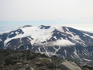
Mount Takawangha is a stratovolcano located in Tanaga Island, Alaska. It sits in close proximity with another volcano known as Mount Tanaga, which shares the same name as the island itself. Older and more eroded volcanoes can also be found east of Takawangha. Its elevation is 4,754 ft, making it the second-highest peak on the island.
This page is based on this
Wikipedia article Text is available under the
CC BY-SA 4.0 license; additional terms may apply.
Images, videos and audio are available under their respective licenses.