
The Wellington Region is a local-government region of New Zealand that occupies the southern end of the North Island. The region covers an area of 8,049 square kilometres (3,108 sq mi), and has a population of 527,800.
Wairarapa is a geographical region of New Zealand. It occupies the south-eastern corner of the North Island, east of metropolitan Wellington and south-west of the Hawke's Bay region. It is lightly populated, having several rural service towns, with Masterton being the largest. It is named after its largest lake, Lake Wairarapa.

Kaitoke, part of Upper Hutt City, is a locality in the southern North Island of New Zealand. It is located at the northern end of the Hutt Valley, 45 kilometres northeast of Wellington City and six kilometres from the northern end of the Upper Hutt urban area. It also lies at the southern end of the Tararua Ranges.

Palmerston North is a city in the North Island of New Zealand and the seat of the Manawatū-Whanganui region. Located in the eastern Manawatu Plains, the city is near the north bank of the Manawatu River, 35 km (22 mi) from the river's mouth, and 12 km (7 mi) from the end of the Manawatu Gorge, about 140 km (87 mi) north of the capital, Wellington. Palmerston North is the country's eighth-largest urban area, with an urban population of 80,300.
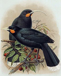
The huia is an extinct species of New Zealand wattlebird, endemic to the North Island of New Zealand. The last confirmed sighting of a huia was in 1907, although there were credible sightings as late as the early 1960s.

Manawatū-Whanganui is a region in the lower half of the North Island of New Zealand, whose main population centres are the cities of Palmerston North and Whanganui. It is administered by the Manawatū-Whanganui Regional Council, which operates under the name Horizons Regional Council.

Eketāhuna is a small rural service town, the most southerly in the Tararua District in the Manawatū-Whanganui region of the North Island of New Zealand, but is considered to be in northern Wairarapa. It was called Mellemskov, but was renamed soon after its founding, and was colloquially known as Jackeytown. The 2013 census recorded Eketahuna's population at 441; down from 456 in 2006.

Waikanae is a town on New Zealand's Kapiti Coast. The name is a Māori word meaning "waters" (wai) "of the grey mullet".

The Tararua District is an area near the south-east corner of New Zealand's North Island that is administered by the Tararua District Council. It has a population of 18,650, and an area of 4,360.56 km². The Tararua District Council was created by the amalgamation of the Dannevirke Borough, Eketahuna County Council, Pahiatua Borough Council, Pahiatua County Council and Woodville District Council in the 1989 local government reforms.
The Ruahine Range is the largest of several mountain ranges in the North Island of New Zealand that form a ridge running parallel with the east coast of the island between East Cape and Wellington. The ridge is at its most pronounced from the central North Island down to Wellington, where it comprises the Ruahine, Tararua and Remutaka Ranges.
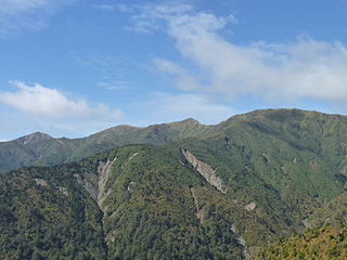
The Tararua Range, often referred to as the Tararua Ranges or the Tararuas, is one of several mountain ranges in the North Island of New Zealand.

The Kaweka Range of mountains is located in inland Hawke's Bay in the eastern North Island of New Zealand. It forms part of the mountainous spine of the North Island which runs from Wellington to East Cape, including the Tararua and Ruahine ranges.

The Manawatu River, often spelled Manawatū in New Zealand English, is a major river of the lower North Island of New Zealand.
Mount Kaukau, [] is a large hill in the northern suburbs of Wellington, New Zealand near Johnsonville, Khandallah and Ngaio. The summit is 445 metres above sea level and is the most visible high point in the Wellington landscape further accentuated by Wellington's main television transmitter mast, which stands 122m from the summit. The city, harbour and the Remutaka and Tararua Ranges can be seen from the summit. On a clear day Mt. Tapuae-o-Uenuku and the Kaikoura Ranges in the South Island may be seen, whilst northwest is the Porirua Basin and the Tasman Sea.

The Mangatainoka River is a river that flows in the Tararua District of New Zealand's North Island. Its water considered so pure a well-known brewery was established there.

Remutaka Forest Park is a protected area near Wellington, New Zealand. Popular access points are south of Wainuiomata and in the upper Hutt Valley. The park covers 220 square kilometres (85 sq mi), encompassing the Catchpool Valley and the Orongorongo Valley at the southern end of the Remutaka Range. Established in 1972, the park contains several short walks and six huts that can be booked and accessed by longer bush tramps. The park is one part of several local conservation areas, as it borders the Pakuratahi Forest and the Tararua Range.

The Hector River is a river of New Zealand's southern North Island. It rises on the northern slopes of Mount Hector in the Tararua Range, flowing east through Tararua Forest Park before joining with the upper reaches of the Waiohine River.
The Waitewaewae River is a river of the Wellington Region of New Zealand's North Island. An upper tributary of the Ōtaki River, it flows south through Tararua Forest Park to reach the Ōtaki 20 kilometres (12 mi) east of Waikanae.
Mitre is the highest mountain of the Tararua Range, situated in the lower North Island of New Zealand. It has a total height of 1,571 metres (5,154 ft).

Tararua Forest Park, often called the Tararuas is a protected area in the Wellington region of New Zealand. Its area is 1,150 square kilometres (440 sq mi), and its highest point, a peak called Mitre, is at 1571 m above sea level. It was established in 1954, as New Zealand's first Forest Park, and is managed by the Department of Conservation (DOC) under the Conservation Act. Tararua Forest Park includes more than three-quarters of the Tararua Range, and its boundaries extend north from New Zealand State Highway 2.