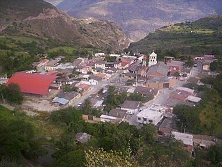
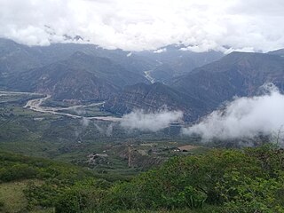
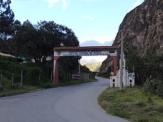
Tipacoque is a municipality and town in Boyacá Department, Colombia, located on the Altiplano Cundiboyacense, part of the Eastern Ranges of the Colombian Andes. Tipacoque is situated on the western flank of the Chicamocha river canyon. It is part of the Northern Boyacá Province.

Zulia River is a river in Venezuela and Colombia. It is a tributary of the Catatumbo River. The Zulia forms a small part of the international boundary between the two countries.

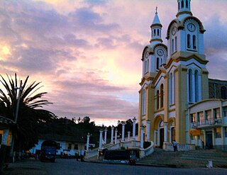
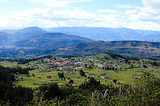
Tota is a town and municipality in the department of Boyacá, Colombia, part of the Sugamuxi Province. Tota is located approximately 40 km from Sogamoso and the municipality borders in the north Cuítiva, Aquitania in the east, Zetaquirá and San Eduardo in the south and westward of Tota the municipality of Pesca is located. Nearby and named after the village is Lake Tota, the largest lake of Colombia.

Villa del Rosario is a Colombian municipality and city located in the eastern part of North Santander department. It is part of the Metropolitan Area of Cúcuta. The municipality is bordered to the north by Venezuela and the municipality of Cúcuta, to the south by the municipalities of Ragonvalia and Chinácota, to the east by Venezuela and to the west by the municipality of Los Patios.
Peștera Vântului is the largest cave in Romania, with a length of almost 52 km. It is situated in the Pădurea Craiului Mountains on the left bank of Crișul Repede River in the vicinity of Șuncuiuș village, Bihor County. This cave is closed and only accessible to cavers, but there are works going on to develop it as a show cave.
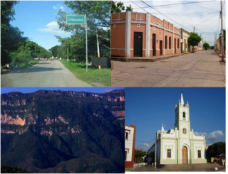
Villanueva is a town and municipality located in the northern Department of La Guajira, Colombia. Villanueva is known in Colombia for being the cradle of many vallenato singers and composers. The economy of the town relies heavily on agriculture and farming.

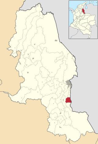
Tibú is a municipality and town of Colombia located in the department of Norte de Santander, in the northeast of the country, on the border with Venezuela and on the banks of the Tibú River. It is the 160th most populated town of Colombia, and the 6th in the department after Cúcuta, Ocaña, Villa del Rosario, Los Patios and Pamplona. It has an airport, and is connected by national road with Cúcuta, Ocaña and El Tarra.
Ragonvalia is a Colombian municipality and town located in the department of North Santander.
Boavita is a town and municipality in the Colombian Department of Boyacá, part of the subregion of the Northern Boyacá Province. The urban centre of Boavita is situated in the Eastern Ranges of the Colombian Andes at an altitude of 2,114 metres (6,936 ft) and a distance of 184 kilometres (114 mi) from the department capital Tunja. The municipality borders Capitanejo, Santander, and the Nevado River in the north, San Mateo and La Uvita in the east, Tipacoque and Soatá in the west and Susacón in the south.
Covarachía is a town and municipality in the Northern Boyacá Province, part of the Colombian Department of Boyacá. The urban centre is located at 208 kilometres (129 mi) from the department capital Tunja at an altitude of 2,320 metres (7,610 ft) in the Eastern Ranges of the Colombian Andes. The municipality borders San José de Miranda and Capitanejo in the north, Tipacoque in the south, Capitanejo in the east and in the west the municipalities Onzaga and San Joaquín (Santander).
Gámeza is a town and municipality in the Colombian Department of Boyacá, part of the Sugamuxi Province, a subregion of Boyacá. The town center is located at 18 kilometres (11 mi) from Sogamoso and the municipality borders Tasco and Corrales in the north, Tópaga and Mongua in the south, in the east Socotá and westward of Gámeza Corrales and Tópaga.
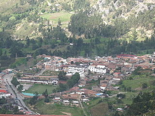
Tópaga is a town and municipality in the Sugamuxi Province, part of the Colombian department of Boyacá. Tópaga is situated on the Altiplano Cundiboyacense with the urban center at an altitude of 2,900 metres (9,500 ft) while the topography varies over the municipality from 2,400 metres (7,900 ft) to 3,200 metres (10,500 ft). It borders Nobsa and Corrales in the west, in the east Mongua and Gámeza, in the north Gámeza and in the south Monguí and Sogamoso. Department capital Tunja is 98 kilometres (61 mi) away. Chicamocha River flows through Tópaga.

Socha is a town and municipality in the Colombian Department of Boyacá, part of the Valderrama Province, which is a subregion of Boyacá. It borders Socotá in the east, Sativasur in the north, Tasco in the south and in the west Paz de Río.
Tasco is a town and municipality in the Valderrama Province, part of the Colombian department of Boyacá. Tasco is situated on the Altiplano Cundiboyacense at altitudes ranging from 2,400 metres (7,900 ft) to 3,800 metres (12,500 ft). The Chicamocha River flows through the municipality which borders Socha in the north, Corrales and Gámeza in the south, Socotá in the east and Betéitiva and Paz de Río in the west. The urban centre is located at an altitude of 2,530 metres (8,300 ft) at 115 kilometres (71 mi) from the department capital Tunja.
Ajajú River is a river of Colombia and a tributary of Apaporis River. It is part of the Amazon River basin.
Manacacías River is a river of Colombia. It is part of the Orinoco River basin.
Moccas Monastery was an early mediaeval monastery near Moccas in Herefordshire, England at grid reference SO35654327. Neither the foundation nor dissolution date is known.

Pigeon Hill is a former village that is now part of the municipality of Saint-Armand, Quebec, Canada, with 25 houses that look out over the farmlands of Quebec to the north and the hills of Vermont to the south. Just 3.2 kilometers or 2 miles from the United States border and about 80 kilometers from both Montreal, Quebec and Burlington, Vermont, the church and most of the houses are over 150 years old. The village was originally called Sagerfield to honor the Sager family.

Ministikwan 161 is an Indian reserve of the Ministikwan Lake Cree Nation in Saskatchewan. It is 161 kilometres (100 mi) north-west of North Battleford. In the 2016 Canadian Census, it recorded a population of 624 living in 128 of its 150 total private dwellings. In the same year, its Community Well-Being index was calculated at 38 of 100, compared to 58.4 for the average First Nations community and 77.5 for the average non-Indigenous community.
