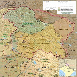
The administrative units of Pakistan comprise four provinces, one federal territory, and two disputed territories: the provinces of Punjab, Sindh, Khyber Pakhtunkhwa, and Balochistan; the Islamabad Capital Territory; and the administrative territories of Azad Jammu and Kashmir and Gilgit–Baltistan. As part of the Kashmir conflict with neighbouring India, Pakistan has also claimed sovereignty over the Indian-controlled territories of Jammu and Kashmir and Ladakh since the First Kashmir War of 1947–1948, but has never exercised administrative authority over either region. All of Pakistan's provinces and territories are subdivided into divisions, which are further subdivided into districts, and then tehsils, which are again further subdivided into union councils.

A hill station is a town located at a higher elevation than the nearby plain or valley. The term was used mostly in colonial Asia, but also in Africa, for towns founded by European colonialists as refuges from the summer heat and, as Dale Kennedy observes about the Indian context, "the hill station ... was seen as an exclusive British preserve: here it was possible to render the Indian into an outsider". In India, which has the largest number of hill stations, most are situated at an altitude of approximately 1,000 to 2,500 metres.

Northern Pakistan is a tourism region in the northern and northwestern parts of Pakistan, comprising the administrative units of Gilgit-Baltistan, Azad Kashmir, Khyber Pakhtunkhwa, and the Pothohar Plateau in Punjab. The first two territories are a part of the wider Kashmir region. Usually, the federal territory of Islamabad is also considered to be in northern Pakistan. It is a mountainous region straddling the Himalayas, Karakoram and the Hindu Kush mountain ranges, containing many of the highest peaks in the world and some of the longest glaciers outside polar regions. Northern Pakistan accounts for a high level of Pakistan's tourism industry.
Paramilitary forces of Pakistan can refer to any of the following:

The Diamer District, also spelled Diamir District,) is a district in Gilgit-Baltistan territory of Pakistan. The headquarters of the district is the town of Chilas. The district is bounded by on the north by the Tangir and the Gilgit districts, on the east by the Astore District, on the south by the Mansehra district of Pakistan's Khyber Pakhtunkhwa Province and the Neelum District of Azad Kashmir, and on the west by the Upper Kohistan District of Khyber Pakhtunkhwa Province. The Karakoram Highway passes through the Diamer District.

Pakistan is a federal republic with three tiers of government: national, provincial and local. Local government is protected by the constitution in Articles 32 and 140-A, and each province also has its own local-government-enabling legislation and ministries responsible for implementation. District councils and metropolitan corporations are respectively the highest rural and urban tiers of local government in the provinces. Both urban and rural local government have two or three tiers in all provinces except Khyber Pakhtunkhwa, where councils are not identified as either urban or rural. There are 129 district councils across the four provinces, 619 urban councils made up of one city district, four metropolitan corporations, 13 municipal corporations, 96 municipal committees, 148 town councils, 360 urban union committees, and 1,925 rural councils. Additionally there are 3339 neighbourhood, ‘tehsil’ and village councils in Khyber Pakhtunkhwa.

Gilgit-Baltistan, formerly known as the Northern Areas, is a region administered by Pakistan as an administrative territory and constituting the northern portion of the larger Kashmir region which has been the subject of a dispute between India and Pakistan since 1947, and between India and China from somewhat later. It borders Azad Kashmir to the south, the province of Khyber Pakhtunkhwa to the west, the Wakhan Corridor of Afghanistan to the north, the Xinjiang region of China, to the east and northeast, and the Indian-administered union territories Jammu and Kashmir and Ladakh to the southeast.

The history of Azad Kashmir, a part of the Kashmir region administered by Pakistan, is related to the history of the Kashmir region during the Dogra rule. Azad Kashmir borders the Pakistani provinces of Punjab and Khyber Pakhtunkhwa to the south and west respectively, Gilgit–Baltistan to the north, and the Indian union territory of Jammu and Kashmir to the east.

The Special Communications Organization (SCO) (Urdu: تنظیم برائے مواصلاتِ مخصوصہ) is Pakistani public sector organization operated by MoIT&T. SCO plays a role in providing telecommunication services in Azad Kashmir and Gilgit Baltistan to almost 1.7 million people, a quarter of the total population.
Karachi Agreement is an agreement purportedly executed on 28 April 1949 between the Government of Pakistan and the then Government of Azad Kashmir governing the relations between Pakistan and Azad Kashmir. It set down the division of the powers between the two governments as well as the All Jammu and Kashmir Muslim Conference. Through the agreement, Azad Kashmir ceded to the Government of Pakistan complete control over Gilgit-Baltistan, and the control over subjects of defence, foreign affairs and communications in its area.

The Ministry of Kashmir Affairs & Gilgit-Baltistan is a ministry of the Government of Pakistan. It handles the regional affairs of Azad Jammu and Kashmir and Gilgit-Baltistan as both territories of Pakistani-administered Kashmir do not have regular provincial status within Pakistan due to political circumstances revolving around the long-running Kashmir conflict.
Jammu and Kashmir may refer to:

Tatta Pani is a village of Diamer district, Gilgit-Baltistan, in Pakistan. It is notable due to the heavy landslides in the area and the worst part of Karakorum Highway.
This page is based on this
Wikipedia article Text is available under the
CC BY-SA 4.0 license; additional terms may apply.
Images, videos and audio are available under their respective licenses.


