Firth is a word in the English and Scots languages used to denote various coastal waters in the United Kingdom, predominantly within Scotland. In the Northern Isles, it more often refers to a smaller inlet. It is linguistically cognate to Scandinavian fjord and fjard, with the original meaning of "sailable waterway". The word has a more constrained sense in English. Bodies of water named "firths" tend to be more common on the Scottish east coast, or in the southwest of the country, although the Firth of Clyde is an exception to this. The Highland coast contains numerous estuaries, straits, and inlets of a similar kind, but not called "firth" ; instead, these are often called sea lochs. Before about 1850, the spelling "Frith" was more common.

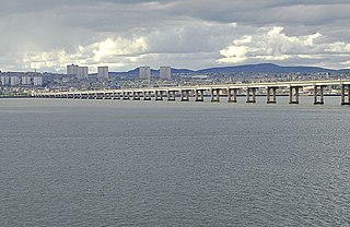
The Tay Bridge carries rail traffic across the Firth of Tay in Scotland between Dundee and the suburb of Wormit in Fife. Its span is 2.75 miles. It is the second bridge to occupy the site.
The Tay Road Bridge carries the A92 road across the Firth of Tay from Newport-on-Tay in Fife to Dundee in Scotland, just downstream of the Tay Rail Bridge. At around 2,250 metres (1.4 mi), it is one of the longest road bridges in Europe, and was opened in 1966, replacing the old Tay ferry.

The Firth of Tay is a firth on the east coast of Scotland, into which empties the River Tay. The firth is surrounded by four council areas: Fife, Perth and Kinross, Dundee City, and Angus. Its maximum width is 3 mi (4.8 km).

The River Tay is the longest river in Scotland and the seventh-longest in Great Britain. The Tay originates in western Scotland on the slopes of Ben Lui, then flows easterly across the Highlands, through Loch Dochart, Loch Iubhair and Loch Tay, then continues east through Strathtay, in the centre of Scotland, then southeasterly through Perth, where it becomes tidal, to its mouth at the Firth of Tay, south of Dundee. It is the largest river in the United Kingdom by measured discharge. Its catchment is approximately 2,000 square miles, the Tweed's is 1,500 sq mi (3,900 km2) and the Spey's is 1,097 sq mi (2,840 km2).

The M90 is a motorway in Scotland. It runs from Junction 1A of the M9 motorway, south of the Queensferry Crossing, to Perth. It is the northernmost motorway in the United Kingdom. The northern point goes to the western suburbs of Perth at Broxden. A small part of the M90 was originally numbered as the M85 motorway.

Broughty Ferry is a suburb of Dundee, Scotland. It is situated four miles east of the city centre on the north bank of the Firth of Tay. The area was a separate burgh from 1864 until 1913, when it was incorporated into Dundee. Historically it is within the County of Angus.

The Friarton Bridge is a steel box girder bridge with a concrete deck, across the River Tay on the southeastern outskirts of Perth, Scotland. It is located approximately 20 miles (32 km) upstream of the Tay Road Bridge.

Forth Ports Limited is a port operator in the United Kingdom based in Edinburgh, Scotland. It is owned by the Public Sector Pension Investment Board.
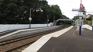
Invergowrie railway station is a railway station which serves the village of Invergowrie, west of the city of Dundee, Scotland on the north bank of the Firth of Tay. It is the only intermediate station between Dundee and Perth, on the Glasgow to Dundee line, approximately 4 miles from Dundee station – and only around 500 yards from the city's western boundary – and just over 17 miles from Perth. ScotRail, who manage the station, provide all the services.

The Tay Bridge disaster occurred during a violent storm on Sunday 28 December 1879, when the first Tay Rail Bridge collapsed as a North British Railway (NBR) passenger train on the Edinburgh to Aberdeen Line from Burntisland bound for its final destination of Dundee passed over it, killing everybody on board. The bridge—designed by Sir Thomas Bouch—used lattice girders supported by iron piers, with cast iron columns and wrought iron cross-bracing. The piers were narrower and their cross-bracing was less extensive and robust than on previous similar designs by Bouch.
The Dundee and Arbroath Railway was an early railway in Scotland. It opened in 1838, and used the unusual track gauge of 5 ft 6 in (1,676 mm). In 1848 it changed to standard gauge and connected to the emerging Scottish railway network.
The Edinburgh and Northern Railway was a railway company authorised in 1845 to connect Edinburgh to both Perth and Dundee. It relied on ferry crossings of the Firth of Forth and the Firth of Tay, but despite those disadvantages it proved extremely successful. It took over a short railway on the southern shore of the Forth giving a direct connection to Edinburgh, and it changed its name to the Edinburgh, Perth and Dundee Railway.
The Newburgh and North Fife Railway was a Scottish railway company formed to build a connecting line between St Fort and Newburgh, in Fife, intended to open up residential traffic between the intermediate communities and Dundee and Perth. It opened its line, which was expensive to construct, in 1909 but the local traffic never developed. It closed to passenger traffic in 1951, and completely in 1964.
The Newport Railway was a Scottish railway company that built a line along the south bank of the Firth of Tay in Fife. The line was opened in 1879, and connected to the Tay Bridge, giving quick access to Dundee; daily residential travel to Dundee from Tayport became a practicality.
The Inner Tay Estuary is the inner, western part of the Firth of Tay, from the Tay Railway Bridge in the east to the Queen's Bridge over the River Tay in Perth and the bridge in Bridge of Earn on the River Earn. It is one of the largest estuaries in eastern Scotland, and is up to 2.5 km wide. It consists primarily of intertidal sand and mud flats extending seaward to the main channel, most of which are on the northern shore. Landward of these are salt marsh and Phragmites reedbeds. The estuary contains two large islands: Mugdrum Island, opposite Newburgh; and Moncreiffe Island, immediately below Perth. The estuary's narrow form, and the large volume of freshwater from the Rivers Tay and Earn, restrict the influence of saltwater west of the Tayport narrows. Much of the tidal water is freshwater or mildly brackish.
Events from the year 1878 in Scotland.
The Firth of Forth was historically crossed by ferry until the opening of the Forth Road Bridge in 1964.
The Dunfermline and Queensferry Railway was a railway company founded to form part of a rail and ferry route between Dunfermline and Edinburgh, in Scotland. It was authorised in 1873 and its promoters had obtained informal promises from the larger North British Railway that the NBR would provide financial help, and also operate the ferry and the necessary railway on the southern side of the Firth of Forth.