
The Chu is a river in Northern Kyrgyzstan and Southern Kazakhstan. Of its total length of 1,067 kilometres (663 mi), the first 115 kilometres are in Kyrgyzstan, then for 221 kilometres the river is the border between Kyrgyzstan and Kazakhstan and the last 731 kilometres are in Kazakhstan. It is one of the longest rivers in Kyrgyzstan and in Kazakhstan. It has a drainage basin of 62,500 square kilometres (24,100 sq mi).
Balykchy is a town at the western end of Lake Issyk-Kul in Kyrgyzstan, at an elevation of about 1,900 metres. Its area is 38 square kilometres (15 sq mi), and its resident population was 42,875 in 2009. A major industrial and transport centre during the Soviet era, it lost most of its economic base after the collapse of the Soviet Union and the closure of virtually all of its industrial facilities.

Issyk-Kul Region is one of the regions of Kyrgyzstan. Its capital is Karakol. It is surrounded by Almaty Region, Kazakhstan (north), Chuy Region (west), Naryn Region (southwest) and Xinjiang, China (southeast). It takes its name from Lake Issyk-Kul, the world's second-largest high altitude lake.
Karakul, in various spellings, means "black lake" in many Turkic languages. It may refer to:
Mikhaylovka or Mikhailovka may refer to:
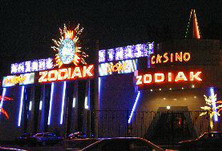
Casino Zodiak is a Kazakh-American gaming company which operates a number of casinos in Kazakhstan, Kyrgyzstan, Egypt, and Northern Cyprus.

Tüp or Tyup is a large village in the Issyk-Kul Region of Kyrgyzstan, and the center of the Tüp District. It was established as village Preobrazhenskoye in 1870. Its population was 9,828 in 2009. Tüp is a road junction town at the northeast corner of Lake Issyk Kul. To the west on A363 is Anan'yevo and to the south Karakol. To the east, A362 leads up the Karkara valley to Kazakhstan.
Temir-Kanat is a village in the Issyk-Kul Region of Kyrgyzstan. Translated the name means 'metal wing'. Its population was 1,068 in 2009.
Temir is a village in the Issyk-Kul Region of Kyrgyzstan. It is part of the Issyk-Kul District. Its population was 3,735 in 2009. Temir / Темир means "iron" in Kyrgyz.

Ak-Suu is a district of Issyk-Kul Region in eastern Kyrgyzstan. The administrative center lies at the village Teploklyuchenka. Its area is 9,917 square kilometres (3,829 sq mi), and its resident population was 63,686 in 2009.

Tong is a district of Issyk-Kul Region in north-eastern Kyrgyzstan. The seat lies at Bökönbaev. Its area is 7,230 square kilometres (2,790 sq mi), and its resident population was 49,130 in 2009. Tong District borders Issyk-Kul District to the north-west, Jeti-Ögüz District to the south and south-east, Kochkor District to the south-west, Naryn District to the south, Kemin District to the north-west, and Issyk Kul - to the north.

Issyk-Kul District is a district of Issyk-Kul Region in north-eastern Kyrgyzstan. The seat lies at Cholpon-Ata. Its area is 3,603 square kilometres (1,391 sq mi), and its resident population was 75,533 in 2009.

The Jeti-Ögüz Rocks is a geological protected area located in Jeti-Ögüz District of Issyk-Kul Province of Kyrgyzstan. It was established in 1975 with a purpose of conservation of a unique geological formation – sheer cliffs composed of Tertiary red conglomerates. The name derives from the rock formation's resemblance to seven bulls and a legend about a khan's unfaithful wife. Another near-by formation is called the 'broken heart'. The rock formation is a well-known landmark in Kyrgyzstan and is seen as a national or regional symbol, and hence is the subject of paintings, songs, and even music videos. The surrounding area is known for its natural environment. The Jeti-Ögüz resort and sanatorium can be found near the foot of the rocks.
“About 25 km west of Karakol, at the mouth of the Jeti-Öghüz canyon is an extraordinary formation of red sandstone cliffs that has become a kind of tourism trademark for Lake Issyk-Kul.
A village of the same name is just off the main around-the-lake road. Beyond it the earth erupts in red patches, and soon there appears a great splintered hill called Razbitoye Serdtse or Broken Heart.
Beyond this on the west side of the road is the massive wall of Jeti-Öghüz. The name means Seven Bulls, and of course there is a story here too – of seven calves growing big and strong in the valley’s rich pastures. Erosion has meant that the bulls have multiplied. They are best viewed from a ridge to the east above the road. From that same ridge you can look east into Ushchelie Drakanov, the Valley of Dragons.”
The Sart Kalmyks are an ethnic group of the Oirats, who live in Issyk Kul Province, Kyrgyzstan. Their population is estimated to be c. 12,000. They are descendants of the Ööled tribes, who moved to the territory of the Russian Empire after the failure of the Dungan revolt, some part inhabited the area during the rule of the Zunghar Khanate. They used to speak in a dialect of the Oirat language, but now completely switched to the Kyrgyz language. As a result of the long co-inhabitance with Kyrgyz people their incorporation into Kyrgyz nation occurred, and now the Kyrgyzs consider them to be one of their tribes. Today majority of them identify themselves as Kyrgyz. They belong to the Muslim faith.
Ak-Suu may refer to the following places in Kyrgyzstan:
Tört-Kül or Tert-Kul' may refer to the following places:
This page is based on this
Wikipedia article Text is available under the
CC BY-SA 4.0 license; additional terms may apply.
Images, videos and audio are available under their respective licenses.