U.S. Route 319 is a spur of U.S. Route 19. It runs for 303 miles (488 km) from the foot of the John Gorrie Memorial Bridge across from downtown Apalachicola, Florida to US 1/SR 4 in Wadley, Georgia, through the Panhandle of Florida and the southern portion of Georgia.
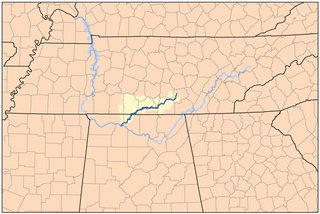
The Elk River is a tributary of the Tennessee River in the U.S. states of Tennessee and Alabama. The river is about 195 miles (314 km) long.
State Route 37 (SR 37) is a 153.6-mile-long (247.2 km) state highway that travels west-to-east through portions of Clay, Calhoun, Baker, Mitchell, Colquitt, Cook, Berrien, Lanier, and Clinch counties in the southwestern and south-central parts of the U.S. state of Georgia. The highway connects the Alabama state line west of Fort Gaines to the Homerville area, via Newton, Camilla, Moultrie, Adel, and Lakeland. The highway actually serves as the eastern terminus of a long multi-state route that starts in Mississippi and goes through Alabama.
State Route 156 is a spur route of Tennessee State Route 56 (SR 56)and a state highway in Franklin and Marion counties in the southern central and southeastern portions of Tennessee, United States. It traverses the southern Cumberland Plateau before descending into the Sequatchie Valley, where follows the shores of Nickajack Lake for its final few miles.
U.S. Route 41 Alternate, also signed U.S. Route 41A in Tennessee (US 41A), connects the town of Monteagle, Tennessee, with Hopkinsville, Kentucky, 10 miles (16 km) north of the Tennessee line. It serves the city of Clarksville, Tennessee, on its way to Nashville, where it briefly runs concurrently with US 41. It then separates again to serve Shelbyville, Winchester, and Tullahoma before rejoining the main route atop Monteagle Mountain. US 41A runs west of US 41 for its entire length, aside from one mile in downtown Nashville where they are concurrent. US 41A is also concurrent with U.S. Route 31A from Nashville to Triune, Tennessee, for a distance of approximately 25 miles (40 km).
State Route 310, also known as Mecca Pike, is a short east–west state highway in McMinn County, Tennessee. It connects Etowah, via SR 39, to Tellico Plains.
State Route 105 is 44.34-mile-long (71.36 km) east–west state highway in West Tennessee. It traverses mainly rural areas and farmland.
State Route 295 is 5.0-mile-long (8.0 km) state highway in Pickett County, Tennessee, connecting SR 111 in Byrdstown to US 127/SR 28 near Pall Mall. For the majority of its length, SR 295 is known as Parker Road.
State Route 307 is a north–south state highway in McMinn and Monroe counties of East Tennessee.
State Route 315, also known as Reliance Road, is a 15.0-mile-long (24.1 km) north–south state highway in the Unicoi Mountains region of southeastern East Tennessee.
State Route 361 is an 8.8 mile long east-west state highway in Carter County, Tennessee. It serves as a connector between Pine Crest and Hampton, as well as provides access to the Laurels Recreation Area section of the Cherokee National Forest.
State Route 399 is 10.6-mile-long (17.1 km) east–west state highway in the Cumberland Plateau region of Tennessee. It serves to connect the towns of Gruetli-Laager and Palmer to Cagle and the Savage Gulf State Natural Area portion of South Cumberland State Park.
State Route 121 is a 20.55 mile long north-south state highway in Middle Tennessee. It connects Elora with Broadview, Tims Ford Lake, and the state of Alabama.
State Route 122 is a 7.11 mile long east-west state highway in Middle Tennessee. It connects the town of Huntland with the community of Elora. For the majority of its length, SR 122 is known as John Hunter Highway.
State Route 445 is a 12.6 mile long east-west state highway in West Tennessee. It connects the towns of Rutherford and Greenfield, as well as providing access to Big Cypress Tree State Park.
State Route 130 is 51.22 mile long east-west state highway in Middle Tennessee.
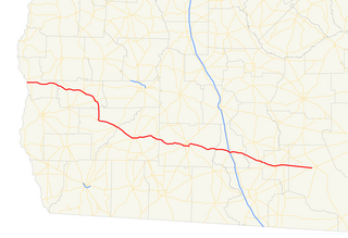
State Route 227 is a 32.3-mile-long (52.0 km) east–west state highway in extreme southern Middle Tennessee. It is the only state highway in Tennessee that both begins and ends at the Alabama state line, with one end at Cypress Inn and the other just across the state line from Lexington, Alabama.
State Route 274, also known as Old Railroad Bed Road, is a 13.1-mile-long (21.1 km) north–south state highway in western Lincoln County, Tennessee.
State Route 279 is a 5.3-mile-long (8.5 km) east–west state highway in Franklin County, Tennessee.