Related Research Articles

Avionics are the electronic systems used on aircraft. Avionic systems include communications, navigation, the display and management of multiple systems, and the hundreds of systems that are fitted to aircraft to perform individual functions. These can be as simple as a searchlight for a police helicopter or as complicated as the tactical system for an airborne early warning platform.

Radar is a system that uses radio waves to determine the distance (ranging), direction, and radial velocity of objects relative to the site. It is a radiodetermination method used to detect and track aircraft, ships, spacecraft, guided missiles, motor vehicles, map weather formations, and terrain.

An altimeter or an altitude meter is an instrument used to measure the altitude of an object above a fixed level. The measurement of altitude is called altimetry, which is related to the term bathymetry, the measurement of depth under water.
Measurement and signature intelligence (MASINT) is a technical branch of intelligence gathering, which serves to detect, track, identify or describe the distinctive characteristics (signatures) of fixed or dynamic target sources. This often includes radar intelligence, acoustic intelligence, nuclear intelligence, and chemical and biological intelligence. MASINT is defined as scientific and technical intelligence derived from the analysis of data obtained from sensing instruments for the purpose of identifying any distinctive features associated with the source, emitter or sender, to facilitate the latter's measurement and identification.

Synthetic-aperture radar (SAR) is a form of radar that is used to create two-dimensional images or three-dimensional reconstructions of objects, such as landscapes. SAR uses the motion of the radar antenna over a target region to provide finer spatial resolution than conventional stationary beam-scanning radars. SAR is typically mounted on a moving platform, such as an aircraft or spacecraft, and has its origins in an advanced form of side looking airborne radar (SLAR). The distance the SAR device travels over a target during the period when the target scene is illuminated creates the large synthetic antenna aperture. Typically, the larger the aperture, the higher the image resolution will be, regardless of whether the aperture is physical or synthetic – this allows SAR to create high-resolution images with comparatively small physical antennas. For a fixed antenna size and orientation, objects which are further away remain illuminated longer – therefore SAR has the property of creating larger synthetic apertures for more distant objects, which results in a consistent spatial resolution over a range of viewing distances.

Imaging radar is an application of radar which is used to create two-dimensional images, typically of landscapes. Imaging radar provides its light to illuminate an area on the ground and take a picture at radio wavelengths. It uses an antenna and digital computer storage to record its images. In a radar image, one can see only the energy that was reflected back towards the radar antenna. The radar moves along a flight path and the area illuminated by the radar, or footprint, is moved along the surface in a swath, building the image as it does so.

A pulse-Doppler radar is a radar system that determines the range to a target using pulse-timing techniques, and uses the Doppler effect of the returned signal to determine the target object's velocity. It combines the features of pulse radars and continuous-wave radars, which were formerly separate due to the complexity of the electronics.

Terrain-following radar (TFR) is a military aerospace technology that allows a very-low-flying aircraft to automatically maintain a relatively constant altitude above ground level and therefore make detection by enemy radar more difficult. It is sometimes referred to as ground hugging or terrain hugging flight. The term nap-of-the-earth flight may also apply but is more commonly used in relation to low-flying military helicopters, which typically do not use terrain-following radar.

A radar altimeter (RA), also called a radio altimeter (RALT), electronic altimeter, reflection altimeter, or low-range radio altimeter (LRRA), measures altitude above the terrain presently beneath an aircraft or spacecraft by timing how long it takes a beam of radio waves to travel to ground, reflect, and return to the craft. This type of altimeter provides the distance between the antenna and the ground directly below it, in contrast to a barometric altimeter which provides the distance above a defined vertical datum, usually mean sea level.
A radar system has look-down/shoot-down capability if it can detect, track and guide a weapon to an air target that is silhouetted against the ground.

Interferometric synthetic aperture radar, abbreviated InSAR, is a radar technique used in geodesy and remote sensing. This geodetic method uses two or more synthetic aperture radar (SAR) images to generate maps of surface deformation or digital elevation, using differences in the phase of the waves returning to the satellite or aircraft. The technique can potentially measure millimetre-scale changes in deformation over spans of days to years. It has applications for geophysical monitoring of natural hazards, for example earthquakes, volcanoes and landslides, and in structural engineering, in particular monitoring of subsidence and structural stability.
A radar system uses a radio-frequency electromagnetic signal reflected from a target to determine information about that target. In any radar system, the signal transmitted and received will exhibit many of the characteristics described below.

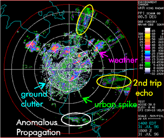
Clutter is the unwanted return (echoes) in electronic systems, particularly in reference to radars. Such echoes are typically returned from ground, sea, rain, animals/insects, chaff and atmospheric turbulences, and can cause serious performance issues with radar systems. What one person considers to be unwanted clutter, another may consider to be a wanted target. However, targets usually refer to point scatterers and clutter to extended scatterers. The clutter may fill a volume or be confined to a surface. A knowledge of the volume or surface area illuminated is required to estimated the echo per unit volume, η, or echo per unit surface area, σ°.
Radar MASINT is a subdiscipline of measurement and signature intelligence (MASINT) and refers to intelligence gathering activities that bring together disparate elements that do not fit within the definitions of signals intelligence (SIGINT), imagery intelligence (IMINT), or human intelligence (HUMINT).

Radio is the technology of communicating using radio waves. Radio waves are electromagnetic waves of frequency between 3 hertz (Hz) and 300 gigahertz (GHz). They are generated by an electronic device called a transmitter connected to an antenna which radiates the waves. They are received by another antenna connected to a radio receiver. In addition to communication, radio is used for radar, radio navigation, remote control, remote sensing, and other applications.
Moving target indication (MTI) is a mode of operation of a radar to discriminate a target against the clutter. It describes a variety of techniques used for finding moving objects, like an aircraft, and filter out unmoving ones, like hills or trees. It contrasts with the modern stationary target indication (STI) technique, which uses details of the signal to directly determine the mechanical properties of the reflecting objects and thereby find targets whether they are moving or not.
Quill was an experimental United States National Reconnaissance Office (NRO) program of the 1960s, which provided the first images of Earth from space using a synthetic aperture radar (SAR). Radar-imaging spacecraft of this design were not intended to be deployed operationally, since it was known that this system's resolution, inferior to that of concurrent experimental airborne systems, would not serve that purpose. Instead, the program's predominant goal was to show whether the propagation of radar waves through a large volume of the atmosphere and ionosphere would dangerously degrade the performance of the synthetic aperture feature.

AIRPASS was a British airborne interception radar and fire-control radar system developed by Ferranti. It was the world's first airborne monopulse radar system and fed data to the world's first head-up display. The name is an acronym for "Airborne Interception Radar and Pilot's Attack Sight System". In the Royal Air Force (RAF) it was given the official name Radar, Airborne Interception, Mark 23, normally shortened to AI.23. AIRPASS was used on the English Electric Lightning throughout its lifetime.

Remote sensing is used in the geological sciences as a data acquisition method complementary to field observation, because it allows mapping of geological characteristics of regions without physical contact with the areas being explored. About one-fourth of the Earth's total surface area is exposed land where information is ready to be extracted from detailed earth observation via remote sensing. Remote sensing is conducted via detection of electromagnetic radiation by sensors. The radiation can be naturally sourced, or produced by machines and reflected off of the Earth surface. The electromagnetic radiation acts as an information carrier for two main variables. First, the intensities of reflectance at different wavelengths are detected, and plotted on a spectral reflectance curve. This spectral fingerprint is governed by the physio-chemical properties of the surface of the target object and therefore helps mineral identification and hence geological mapping, for example by hyperspectral imaging. Second, the two-way travel time of radiation from and back to the sensor can calculate the distance in active remote sensing systems, for example, Interferometric synthetic-aperture radar. This helps geomorphological studies of ground motion, and thus can illuminate deformations associated with landslides, earthquakes, etc.

A cosecant squared antenna, sometimes known as a constant height pattern, is a modified form of parabolic reflector used in some radar systems. It is shaped to send more radio energy in certain directions in order to smooth out the reception pattern of objects as their range changes in relation to the radar. The name refers to the fact that the amount of energy returned from a target drops off with the square of the cosecant of the angle between the radar and the target.