
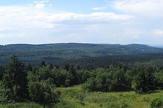
The Teutoburg Forest is a range of low, forested hills in the German states of Lower Saxony and North Rhine-Westphalia. Until the 17th century, the official name of the hill ridge was Osning. It was first renamed the Teutoburg Forest in 1616 in commemoration of the Battle of the Teutoburg Forest in 9 AD, which most likely took place at Kalkriese instead.
Höxter is a Kreis (district) in the east of North Rhine-Westphalia, Germany. Neighboring districts are Holzminden, Northeim, Kassel, Waldeck-Frankenberg, Hochsauerland, Paderborn, and Lippe.
Lippe is a Kreis (district) in the east of North Rhine-Westphalia, Germany. Neighboring districts are Herford, Minden-Lübbecke, Höxter, Paderborn, Gütersloh, and district-free Bielefeld, which forms the region Ostwestfalen-Lippe.
The Weser Uplands is a hill region in Germany, between Hannoversch Münden and Porta Westfalica, along the river Weser. The area reaches into three states, Lower Saxony, Hesse, and North Rhine-Westphalia. Important towns of this region include Bad Karlshafen, Holzminden, Höxter, Bodenwerder, Hameln, Rinteln, and Vlotho.

The Senne is a natural region in the Regierungsbezirk of Detmold, in the state of Nordrhein-Westfalen in west-central Germany. It lies to the west of the Teutoburger Forest, and has an area of approximately 210 km2. It lies between the cities of Bielefeld to the north-west, Detmold to the north-east, and Paderborn to the south.

The Gehn is a small ridge of hills between Bramsche and Ueffeln in Germany's Central Uplands, that are an extension of the Wiehen Hills . The ridge runs from northwest to southeast and is about 5 kilometres (3.1 mi) long and an average of 2 kilometres (1.2 mi) wide. The highest point is the Kettelberg which is 108 m above sea level (NN) high. The Gehn forms a link between the Wiehen Hills and the Ankum Heights. It is largely forested and is not - like the Ankum Heights- part of a series of ice age terminal moraines from the latest event of the Saalian glaciation, the so-called Drenthe I stage, but is a ridge of Jurassic rock that was pushed up during the folding towards the end of the Cretaceous period.

Horn-Bad Meinberg is a German city in the Lippe district in the north-east of North Rhine-Westphalia on the edge of the Teutoburg forest. The district Bad Meinberg is a spa resort. It has 17,263 inhabitants (2019). It was formed in 1970 by merging various other municipalities that had grown together, including Bad Meinberg and Horn - the new entity's original name was Bad Meinberg-Horn, before taking its present name.

The Egge Hills, or just the Egge is a range of forested hills, up to 464 m above sea level (NN), in the east of the German state of North Rhine-Westphalia.
The Westphalian Lowland, also known as the Westphalian Basin is a flat landscape that mainly lies within the German region of Westphalia, although small areas also fall within North Rhine and in Lower Saxony. Together with the neighbouring Lower Rhine Plain to the west, it represents the second most southerly region of the North German Plain, after the Cologne Bight. It is variously known in German as the Westfälische Bucht, the Münsterländer or Westfälische Tieflands- or Flachlandsbucht.

The Weser Hills (Wesergebirge), also known in German as the Weserkette, form a low hill chain, up to 326.1 m above sea level (NN), in the Weser Uplands in the German states of North Rhine-Westphalia and Lower Saxony.
The Nethegau is a region in central Germany named after the river Nethe and covers, in the main, the Brakel Upland between the River Weser and the Egge ridge around the towns of Brakel and Bad Driburg in the district of Höxter in North Rhine-Westphalia.
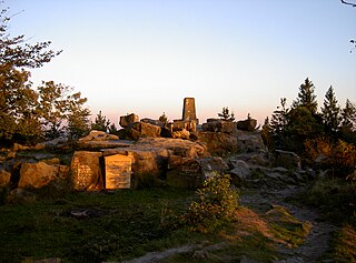
At 446.4 m above sea level (NN) the Barnacken is the highest hill in the Teutoburg Forest in the German state of North Rhine-Westphalia.

The TERRA.vita Nature Park is located in the German states of Lower Saxony and North Rhine-Westphalia and is divided into northern and southern areas. The park is also known as the Osnabrück Land Nature Park and sometimes by its old name of North Teutoburg Forest-Wiehen Hills Nature Park.

The Köterberg, at 495.8 m (1,627 ft) above sea level, is the highest hill in the Lippe Uplands and lies on the state border between North Rhine-Westphalia and Lower Saxony in North Germany. On its northern slopes is the village of Köterberg.

The Solling-Vogler Nature Park is a nature park in South Lower Saxony in Germany. It has an area of 52,000 hectares (200 sq mi) and was established in 1966.
The Velmerstot is the northernmost and highest hill in the Eggegebirge ridge in the German state of North Rhine-Westphalia. It has two summits, the Prussian Velmerstot (468 m), which lies on the territory of Steinheim-Sandebeck in the county of Höxter, and the Lippe Velmerstot, which is located in the county of Lippe. The whole hill is part of the Teutoburg Forest / Egge Hills Nature Park.
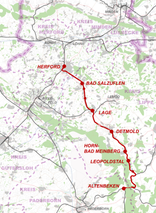
The Herford–Himmighausen railway is a 48 km-long line from Herford via Detmold to Himmighausen and is a single-track and electrified main line. It is located in Ostwestfalen-Lippe in the German state of North Rhine-Westphalia and is part of Deutsche Bahn’s Münster-Ostwestfalen regional network (MOW), which has its headquarters in Münster. In Herford this route is known as the Lippische Bahn. The line from Herford to Detmold was built by the Cologne-Minden Railway Company.

The Hermannsweg is a 156 kilometres (97 mi) long hiking trail which follows the ridge of the Teutoburg Forest, running from Rheine to Velmerstot in Germany. It is marked by signposts showing a white H on a black background. The Hermannsweg has been named for Arminius, a Cherusci chief who defeated the Romans in the Battle of the Teutoburg Forest in 9 AD. Together with the 70 kilometres (43 mi) long Eggeweg, this long-distance hiking trail forms the Hermannshöhen. It is maintained by the Teutoburger-Wald-Verein e.V. located in Bielefeld.


