The Shalmani or Shilmani is a Pashtun tribe primarily concentrated in the Shalman Valley in Khyber Agency near Peshawar, Khyber Pakhtunkhwa, Pakistan. Shalmani is also known as Sulemani a variant of Shalmani in, Mansehra and Haripur. The tribe is present in different parts of Pakistan. In Pakistan, the tribe lives in Swat, Upper Dir, Lower Dir, Bajour, Buner, Shangla, Malakand District, Dargai, Charsadda (Hashtnagar).
Dargai is one of the tehsils of Malakand District in Pakistan's northwestern Khyber Pakhtunkhwa province. It located on the main highway from Peshawar to Swat, Dir and Chitral.
Chakdara is a city in Lower Dir District of Khyber-Pakhtunkhwa, in Pakistan.The city serves as an educational center of Malakand Division and the Gateway of Dir District. It is located north of Malakand near the confluence of the Swat River with the Panjkora River, in a commanding position near the entrance to Swat District and at the entrance to Lower Dir. It is about 130 km from Peshawar and 40km from Mingora.The Swat Expressway collect Malakand Division at Pul Saokie Chakdara interchange.

The Panjkora River is a river in the Khyber Pakhtunkhwa province of the northwest of Pakistan. The river runs through the mountainous northern part of the province, and forms the Kumrat Valley. It passes from Dir, Timergara and meet at Chakdara with Swat river. It generally characterized by having steep slopes on either side of the riverbank covered in thick forests. The river has a large catchment area, making the river susceptible to significant flooding - most notably during the 2010 floods that occurred throughout much of Pakistan.

Buner District is a district in Malakand Division of Khyber Pakhtunkhwa province in Pakistan. Before becoming a district in 1991, it was a tehsil within Swat District.

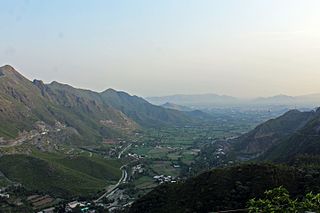
Malakand Division is an administrative division of the Khyber Pakhtunkhwa of Pakistan. It contains the following districts:

Bajaur District is a district in Malakand Division of Khyber Pakhtunkhwa province in Pakistan. Until 2018, it was an agency of the Federally Administered Tribal Areas, then during restructuring that merged FATA with Khyber Pakhtunkhwa, it became a district. According to the 2017 census, the population of the district is 1,093,684. It borders Afghanistan's Kunar Province with a 52 km border. The headquarters of the agency administration is located in the town of Khar.
Malakand District is a district in Malakand Division of Khyber Pakhtunkhwa province in Pakistan.

Malakand Levies is a paramilitary force in the Pakistani province of Khyber Pakhtunkhwa, Malakand Division. It operates as the primary law enforcement agency tasked with maintaining law and order within the division. The force has its origins back in the days of the British Raj, and has continued to function for over a century.
Major General (R) Khurshid Ali Khan was the Governor of the North-West Frontier Province from 1993 to 1996.
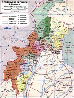
The Malakand Agency was one of the agencies in the North West Frontier Province of British India and later of Pakistan until 1970. It included the princely states of Chitral, Dir and Swat, and an area around the Malakand Pass known as the Malakand Protected Area. The largest city in the area was Mingora, while the three state capitals were Chitral, Dir, and Saidu Sharif. In 1970, following the abolition of the princely states, the agency became the Malakand Division, which was divided into districts, one of which was the Malakand Protected Area, known as Malakand District. In 2000 the Malakand Division was abolished. Despite the constitutional changes since 1970, the expression Malakand Agency is still used, sometimes of the entire area of the former Agency, but more often of Malakand District.

Batkhela is the main tehsil, city and capital of Malakand District, Khyber Pakhtunkhwa, Pakistan. According to the 6th Population & Housing Census - the 2017 Census of Pakistan, the population of Batkhela was recorded at 68,200. Batkhela is a popular business city in Khyber Pakhtunkhwa province. One water canal that pours into a small dam in Jabban area is the main source of electricity production.
This is a list of terrorist incidents in Pakistan in 2014.
Gunyar or Gul-e-Anaar is a village near Thana, Malakand district, Pakistan. The residents of the village consist mostly of Madey-Khel Miagaan. The nearby villages of Gunyar are Thana, Chapai, Maizara, Aladhand Dherai and Nalu. Most of the people of this village also live in Karachi, U.A.E, Saudi Arabia, Qatar and England.

Alladand Dheri are two administrative units, known as Union council, of Malakand District in the Khyber Pakhtunkhwa province of Pakistan.
Palai is an administrative unit, known as Union council, of Malakand District in the Khyber Pakhtunkhwa province of Pakistan. It is renowned for its blood-red oranges due to the rich and well-drained soil found there.
Alladand Dheri, village near river swat, in the district Malakand, KPK.JPG|thumb|Alladand Dheri ]] Alladand Dheri is a village which consists of two union councils Alladand and Dheri respectively in the Swat Ranizai Tehsil of Malakand District of PakistanAlladand Dheri is situated in the mid of Malakand and is one of the well known towns in Pashtun lands, known for its history, natural environment and hospitality. It is considered the oldest home of Yousufzai Tribe when they migrated from Afghanistan and settled in Alladand Dheri. The chief of Yousufzai tribe and founder of free Pakhtunkhwa state, Malak Ahmad baba made it capital of the new state. The Pashtun leader Malak Ahmad baba is buried in Alladand Dheri. People of Alladand Dheri are entirely Pashtun and are from Alikhel subtribe of Yousufzai tribe. The land of this town is fertile and is irrigated by River Swat. It shares a major part of supply of fruits and vegetables from Malakand District to whole Pakistan.
The Swat Motorway(Urdu: سوات موٹر وے, Pashto: سوات بزرگراه ), also known as the M-16 or Swat Expressway, is a 160-kilometre-long (99 mi) four-lane motorway and provincial controlled-access highway in the Khyber Pakhtunkhwa province of Pakistan. Phase-1 of the project, completed in June 2019, connects the existing M-1 motorway at Nowshera to Chakdara while the under-construction second phase will extend the project to Fatehpur.

The Dir Levies is a paramilitary force in the Dir District of the Pakistani province of Khyber Pakhtunkhwa. It operates as the primary law enforcement agency tasked with maintaining law and order within the division. The force has its origins back in the days of the British Raj, and has continued to function for over a century.
