
Banff National Park is Canada's oldest national park, established in 1885 as Rocky Mountains Park. Located in Alberta's Rocky Mountains, 110–180 kilometres (68–112 mi) west of Calgary, Banff encompasses 6,641 square kilometres (2,564 sq mi) of mountainous terrain, with many glaciers and ice fields, dense coniferous forest, and alpine landscapes. The Icefields Parkway extends from Lake Louise, connecting to Jasper National Park in the north. Provincial forests and Yoho National Park are neighbours to the west, while Kootenay National Park is located to the south and Kananaskis Country to the southeast. The main commercial centre of the park is the town of Banff, in the Bow River valley.

The Continental Divide National Scenic Trail is a United States National Scenic Trail with a length measured by the Continental Divide Trail Coalition of 3,028 miles (4,873 km) between the U.S. border with Chihuahua, Mexico and the border with Alberta, Canada. Frequent route changes and a large number of alternate routes result in an actual hiking distance of 2,700 miles (4,300 km) to 3,150 miles (5,070 km). The CDT follows the Continental Divide of the Americas along the Rocky Mountains and traverses five U.S. states — Montana, Idaho, Wyoming, Colorado, and New Mexico. In Montana near the Canadian border the trail crosses Triple Divide Pass.

Kootenay National Park is a national park of Canada located in southeastern British Columbia. The park consists of 1,406 km2 (543 sq mi) of the Canadian Rockies, including parts of the Kootenay and Park mountain ranges, the Kootenay River and the entirety of the Vermilion River. While the Vermilion River is completely contained within the park, the Kootenay River has its headwaters just outside the park boundary, flowing through the park into the Rocky Mountain Trench and eventually joining the Columbia River. The park ranges in elevation from 918 m (3,012 ft) at the southwestern park entrance to 3,424 m (11,234 ft) at Deltaform Mountain.
Castle Junction is a locality where the northern extent of the Banff–Windermere Highway intersects with the Trans-Canada Highway, the Bow River, and Bow Valley Parkway in Banff National Park, Alberta. It is named after the nearby Castle Mountain, clearly visible from the junction. The area is also referred to as Castle Mountain; however, the official location is approximately 1.6 km (1.0 mi) southwest of Castle Junction along the Canadian Pacific Railway.

Mount Rundle is a mountain in Canada's Banff National Park overlooking the towns of Banff and Canmore, Alberta. The Cree name was Waskahigan Watchi or house mountain. In 1858 John Palliser renamed the mountain after Reverend Robert Rundle, a Methodist invited by the Hudson's Bay Company to do missionary work in western Canada in the 1840s. He introduced syllabics there—a written language developed for the Cree, as part of his missionary work. He only visited the Stoney-Nakoda of the area around what is now called Mount Rundle in 1844 and 1847.
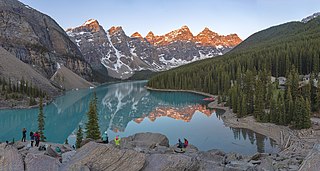
Moraine Lake is a glacially fed lake in Banff National Park, 14 kilometres (8.7 mi) outside the hamlet of Lake Louise, Alberta, Canada. It is situated in the Valley of the Ten Peaks, at an elevation of approximately 1,884 metres (6,181 ft). The lake has a surface area of 50 hectares.
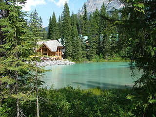
Emerald Lake is a freshwater lake located in Yoho National Park, British Columbia, Canada. Yoho National Park is one of the 4 contiguous National Parks in the heart of Canada's Rocky Mountains, along the boundary of British Columbia and Alberta Provinces, the other Parks are Kootenay, Jasper, and Banff.

Castle Mountain is a mountain located within Banff National Park in the Canadian Rockies, approximately halfway between Banff and Lake Louise. It is the easternmost mountain of the Main Ranges in the Bow Valley and sits astride the Castle Mountain Fault which has thrust older sedimentary and metamorphic rocks forming the upper part of the mountain over the younger rocks forming its base. The mountain's castellated, or castle-like, appearance is a result of erosive processes acting at different rates on the peak's alternating layers of softer shale and harder limestone, dolomite and quartzite.

Banff Sunshine Village is a ski resort in western Canada, located on the Continental Divide of the Canadian Rockies within Banff National Park in Alberta and Mt Assiniboine Provincial Park in British Columbia. It is one of three major ski resorts located in the Banff National Park. Because of its location straddling the Continental Divide, Sunshine receives more snow than the neighbouring ski resorts. The Sunshine base area is located 15 km (9 mi) southwest of the town of Banff. By car, it is about a ninety-minute drive from the city of Calgary; the Sunshine exit on the Trans Canada Highway is 8 km (5 mi) west of the town of Banff.

Mount Assiniboine Provincial Park is a provincial park in British Columbia, Canada, located around Mount Assiniboine.

Alberta has been a tourist destination since the early days of the 20th Century, with attractions including national parks, National Historic Sites of Canada, urban arts and cultural facilities, outdoor locales for skiing, hiking and camping, shopping locales such as West Edmonton Mall, outdoor festivals, professional athletic events, international sporting competitions such as the Commonwealth Games and Olympic Winter Games, as well as more eclectic attractions.
The Stanley Mitchell hut is an alpine hut located at an altitude of 2,060 metres (6,759 ft) in the Little Yoho Valley in Yoho National Park, British Columbia. It sits in a small meadow not far from the base of a mountain called The President. It serves as a base for hiking, scrambling, ski-touring and climbing the nearby mountains. The hut is maintained by the Alpine Club of Canada.
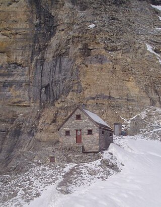
The Abbot Pass hut was an alpine hut located at an altitude of 2,925 metres (9,596 ft) in Abbot Pass in the Rocky Mountains in Alberta, Canada. It was nestled between Mount Victoria and Mount Lefroy, straddling the continental divide, which, in this region, defines the boundary between Banff National Park in Alberta and Yoho National Park in British Columbia. While close to the border, the hut lay entirely in Banff National Park, and was the second-highest permanently habitable structure in Canada. The hut was maintained by the Alpine Club of Canada.

Lake O'Hara is a lake at an elevation of 2,020 metres (6,630 ft) in the alpine area of Yoho National Park, in the province of British Columbia, on the western side of the Great Divide with the province of Alberta and Banff National Park to the east. The lake and the valley are accessible through a bus service that is run by Parks Canada or by an 11 km hike along a road with an elevation gain of approximately 500m.

The Great Divide Trail (GDT) is a wilderness hiking trail in the Canadian Rockies. The trail closely follows the Great Divide between Alberta and British Columbia, crossing the divide more than 30 times. Its southern terminus is in Waterton Lakes National Park at the Canada–US border and its northern terminus is at Kakwa Lake in Kakwa Provincial Park, north of Jasper National Park. The trail is 1,130 km (700 mi) long and ranges in elevation from 1,055 m (3,461 ft) at Old Fort Point trailhead near Jasper to 2,590 m (8,500 ft) at an unnamed pass above Michele Lakes just south of the White Goat Wilderness Area.

The Bow Range is a mountain range of the Canadian Rockies in Alberta and British Columbia, Canada. The range is named in associated with the Bow River and was officially adopted on March 31, 1917 by the Geographic Board of Canada.
The Sunshine Meadows are a natural garden set at an altitude of approximately 2,300 metres. It is located within the peaks of the Canadian Rocky Mountains of Banff National Park. From the vantage point of Sunshine Meadows one has a clear view of Mount Assiniboine, the highest peak in the region at 3,618 metres. Sunshine Meadows is located 18 km directly southwest of Banff, Alberta, and spans along both sides of the Continental Divide.
The San Pedro Parks Wilderness is located in southern Rio Arriba County in northern New Mexico and part of the Santa Fe National Forest. It is 41,132 acres (16,646 ha) in size. Elevations range from 8,300 feet (2,500 m) in the southwestern corner to 10,592 feet (3,228 m) at San Pedro Peaks near the center of the Wilderness. The Wilderness's average elevation is over 10,000 ft. Conifer forests, interspaced with grassy meadows, called "parks," characterize the wilderness. San Pedro Parks Wilderness is primarily visited for hiking, camping, hunting, and fishing. The Continental Divide Trail passes through the Wilderness.

The Tahoe–Yosemite Trail (TYT) is a long-distance trail in the Sierra Nevada mountain range of California. The trail courses 186 miles (299 km) from Meeks Bay at Lake Tahoe to Tuolumne Meadows in Yosemite National Park. The trail is a foot and equestrian path that passes through the Desolation, Mokelumne, Carson-Iceberg, Emigrant, and Yosemite Wilderness Areas and the Meiss Country (Dardanelles) Roadless Area.

Parker Ridge is a 2,255-metre (7,398-foot) mountain ridge located in the upper North Saskatchewan River valley in Banff National Park, in the Canadian Rockies of Alberta, Canada. Its nearest higher peak is Mount Athabasca, 7.7 km (4.8 mi) to the west. Parker Ridge is situated along the west side of the Icefields Parkway and southeast of Sunwapta Pass. Parker Ridge is a ski-touring destination in the winter and popular hiking destination in the summer because it is situated beside the Icefields Parkway allowing easy access, and is nearly entirely above treeline allowing good views of the surrounding mountain landscape. A 2.2 km (1.4 mi) trail gains 275 metres (900 ft) of elevation from the highway to the top of the ridge. Wandering east or west along the ridge provides views of Cirrus Mountain, the north face of Mount Saskatchewan, Saskatchewan Glacier, Mount Athabasca, Hilda Peak, and Nigel Peak among others.
