The Dividing Island is the second full-length album by Lansing-Dreiden. It was released in 2006.
| No. | Title | Length |
|---|---|---|
| 1. | "Dividing Island" | 5:39 |
| 2. | "Cement to Stone" | 3:33 |
| 3. | "A Line You Can Cross" | 3:31 |
| 4. | "One For All" | 4:07 |
| No. | Title | Length |
|---|---|---|
| 5. | "Two Extremes" | 3:46 |
| 6. | "Part of the Promise" | 3:36 |
| 7. | "Our Next Breath" | 3:55 |
| 8. | "Our Hour" | 3:01 |
| 9. | "Symbol of Symmetry" | 2:22 |
| 10. | "Dethroning the Optimyth" | 3:18 |
| Total length: | 36:48 | |

An archipelago, sometimes called an island group or island chain, is a chain, cluster, or collection of islands, or sometimes a sea containing a small number of scattered islands.

Timor is an island at the southern end of Maritime Southeast Asia, in the north of the Timor Sea. The island is divided between the sovereign states of East Timor in the eastern part and Indonesia in the western part. The Indonesian part, known as West Timor, constitutes part of the province of East Nusa Tenggara. Within West Timor lies an exclave of East Timor called Oecusse District. The island covers an area of 30,777 square kilometres. The name is a variant of timur, Malay for "east"; it is so called because it lies at the eastern end of the Lesser Sunda Islands. Mainland Australia is less than 500 km away, separated by the Timor Sea.

The Treaty of Tordesillas, signed in Tordesillas, Spain, on 7 June 1494, and ratified in Setúbal, Portugal, divided the newly discovered lands outside Europe between the Kingdom of Portugal and the Crown of Castile, along a meridian 370 leagues west of the Cape Verde islands, off the west coast of Africa. That line of demarcation was about halfway between Cape Verde and the islands visited by Christopher Columbus on his first voyage, named in the treaty as Cipangu and Antillia.

The Lesser Antilles is a group of islands in the Caribbean Sea, forming part of the West Indies in Caribbean region of the Americas. They are distinguished from the larger islands of the Greater Antilles to the west. They form an arc which begins east of Puerto Rico at the archipelago of the Virgin Islands, swings southeast through the Leeward and Windward Islands towards South America, and turns westward through the Leeward Antilles along the Venezuelan coast.

An unincorporated area is a region that is not governed by a local municipal corporation. There are many unincorporated communities and areas in the United States and Canada.

For local government purposes, Scotland is divided into 32 areas designated as "council areas", which are all governed by single-tier authorities designated as "councils". They have the option under the Local Government (Scotland) Act 1997 of being known as a "comhairle" when opting for a Gaelic name; only Comhairle nan Eilean Siar has chosen this option, whereas the Highland Council has adopted its Gaelic form alongside its English equivalent, informally.

The administrative divisions of France are concerned with the institutional and territorial organization of French territory. These territories are located in many parts of the world. There are many administrative divisions, which may have political, electoral (districts), or administrative objectives. All the inhabited territories are represented in the National Assembly, Senate and Economic and Social Council and their citizens have French citizenship and elect the President of France.
The three islands of the Cayman Islands are the exposed top of an underwater mountain. Underwater, the sides of this mountain are quite steep, vertical in some places, within as little as a few hundred metres from shore.
Subprefecture of Japan are a Japanese form of self-government which focuses on local issues below the prefectural level. It acts as part of the greater administration of the state and as part of a self-government system.
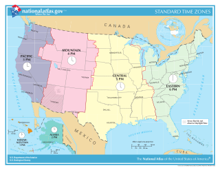
In the United States, time is divided into nine standard time zones covering the states, territories and other US possessions, with most of the country observing daylight saving time (DST) for approximately the spring, summer, and fall months. The time zone boundaries and DST observance are regulated by the Department of Transportation, but no single map of those existed until the agency announced intentions to make one in September 2022. Official and highly precise timekeeping services (clocks) are provided by two federal agencies: the National Institute of Standards and Technology (NIST) ; and the United States Naval Observatory (USNO). The clocks run by these services are kept synchronized with each other as well as with those of other international timekeeping organizations.

This is a list of properties and historic districts in Hawaii listed on the National Register of Historic Places. More than 370 listings appear on all but one of Hawaii's main islands and the Northwestern Islands, and in all of its five counties. Included are houses, schools, archeological sites, ships, shipwrecks and various other types of listings. These properties and districts are listed by island, beginning at the northwestern end of the chain.
This National Park Service list is complete through NPS recent listings posted October 11, 2024.

The territory of Cape Verde is divided into 22 concelhos (municipalities), and subdivided into 32 freguesias.
The World Geographical Scheme for Recording Plant Distributions (WGSRPD) is a biogeographical system developed by the international Biodiversity Information Standards (TDWG) organization, formerly the International Working Group on Taxonomic Databases. The WGSRPD standards, like other standards for data fields in botanical databases, were developed to promote "the wider and more effective dissemination of information about the world's heritage of biological organisms for the benefit of the world at large". The system provides clear definitions and codes for recording plant distributions at four scales or levels, from "botanical continents" down to parts of large countries. The codes may be referred to as TDWG geographical codes. Current users of the system include the International Union for Conservation of Nature (IUCN), the Germplasm Resources Information Network (GRIN), and Plants of the World Online (POWO).
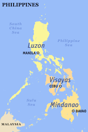
The Philippines is divided into three major island groups: Luzon, the Visayas, and Mindanao. Luzon and Mindanao archipelagoes are both named after the largest island in their respective groups, while the Visayas is an archipelago of roughly similar-sized islands.

A continent is any of several large geographical regions. Continents are generally identified by convention rather than any strict criteria. A continent could be a single landmass or a part of a very large landmass, as in the case of Asia or Europe. Due to this, the number of continents varies; up to seven or as few as four geographical regions are commonly regarded as continents. Most English-speaking countries recognize seven regions as continents. In order from largest to smallest in area, these seven regions are Asia, Africa, North America, South America, Antarctica, Europe, and Australia. Different variations with fewer continents merge some of these regions; examples of this are merging North America and South America into America, Asia and Europe into Eurasia, and Africa, Asia, and Europe into Afro-Eurasia.