Related Research Articles

The Missouri River is a river in the Central and Mountain West regions of the United States. The nation's longest, it rises in the eastern Centennial Mountains of the Bitterroot Range of the Rocky Mountains of southwestern Montana, then flows east and south for 2,341 miles (3,767 km) before entering the Mississippi River north of St. Louis, Missouri. The river drains semi-arid watershed of more than 500,000 square miles (1,300,000 km2), which includes parts of ten U.S. states and two Canadian provinces. Although a tributary of the Mississippi, the Missouri River is slightly longer and carries a comparable volume of water. When combined with the lower Mississippi River, it forms the world's fourth-longest river system.

The Great Plains, sometimes simply "the Plains", is a broad expanse of flatland in North America. It is located just to the east of the Rocky Mountains, much of it covered in prairie, steppe, and grassland. It is the western part of the Interior Plains, which also include the mixed grass prairie, the tallgrass prairie between the Great Lakes and Appalachian Plateau, and the Taiga Plains and Boreal Plains ecozones in Northern Canada. Great Plains or Western Plains is also used to describe the ecoregion of the Great Plains, or alternatively the western portion of the Great Plains.

Indian Territory and the Indian Territories are terms that generally described an evolving land area set aside by the United States government for the relocation of Native Americans who held original Indian title to their land as an independent nation-state. The concept of an Indian territory was an outcome of the U.S. federal government's 18th- and 19th-century policy of Indian removal. After the American Civil War (1861–1865), the policy of the U.S. government was one of assimilation.

Prairies are ecosystems considered part of the temperate grasslands, savannas, and shrublands biome by ecologists, based on similar temperate climates, moderate rainfall, and a composition of grasses, herbs, and shrubs, rather than trees, as the dominant vegetation type. Temperate grassland regions include the Pampas of Argentina, Brazil and Uruguay, and the steppe of Ukraine, Russia and Kazakhstan. Lands typically referred to as "prairie" tend to be in North America. The term encompasses the area referred to as the Interior Lowlands of Canada, the United States, and Mexico, which includes all of the Great Plains as well as the wetter, hillier land to the east.

The Midwestern United States, also referred to as the Midwest or the American Midwest, is one of four census regions of the United States Census Bureau. It occupies the northern central part of the United States. It was officially named the North Central Region by the U.S. Census Bureau until 1984. It is between the Northeastern United States and the Western United States, with Canada to the north and the Southern United States to the south.
Pierre Part is a census-designated place (CDP) in Assumption Parish, Louisiana, United States. The population was 3,169 at the 2010 census, making it the most populous community in Assumption Parish. With 39.3 percent of the population speaking French at home, Pierre Part is the most French town in the United States outside of Maine. Pierre Part is known locally for its prominent French influence and ancestry, which have become significant aspects of its contemporary local culture. Situated near Lake Verret, Pierre Part is a popular local destination for water sports and fishing during the summer.

The Ogallala Aquifer is a shallow water table aquifer surrounded by sand, silt, clay, and gravel located beneath the Great Plains in the United States. As one of the world's largest aquifers, it underlies an area of approximately 174,000 sq mi (450,000 km2) in portions of eight states. It was named in 1898 by geologist N. H. Darton from its type locality near the town of Ogallala, Nebraska. The aquifer is part of the High Plains Aquifer System, and resides in the Ogallala Formation, which is the principal geologic unit underlying 80% of the High Plains.
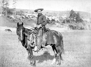
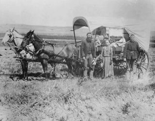
The American frontier, also known as the Old West, and popularly known as the Wild West, encompasses the geography, history, folklore, and culture associated with the forward wave of American expansion in mainland North America that began with European colonial settlements in the early 17th century and ended with the admission of the last few contiguous western territories as states in 1912. This era of massive migration and settlement was particularly encouraged by President Thomas Jefferson following the Louisiana Purchase, giving rise to the expansionist attitude known as "manifest destiny" and historians' "Frontier Thesis". The legends, historical events and folklore of the American frontier have embedded themselves into United States culture so much so that the Old West, and the Western genre of media specifically, has become one of the defining features of American national identity.
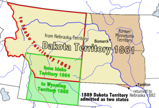
The Territory of Dakota was an organized incorporated territory of the United States that existed from March 2, 1861, until November 2, 1889, when the final extent of the reduced territory was split and admitted to the Union as the states of North and South Dakota.

The Territory of Wyoming was an organized incorporated territory of the United States that existed from July 25, 1868, until July 10, 1890, when it was admitted to the Union as the State of Wyoming. Cheyenne was the territorial capital. The boundaries of the Wyoming Territory were identical to those of the modern State of Wyoming.

The territory of the United States and its overseas possessions has evolved over time, from the colonial era to the present day. It includes formally organized territories, proposed and failed states, unrecognized breakaway states, international and interstate purchases, cessions, and land grants, and historical military departments and administrative districts. The last section lists informal regions from American vernacular geography known by popular nicknames and linked by geographical, cultural, or economic similarities, some of which are still in use today.

A building code is a set of rules that specify the standards for construction objects such as buildings and non-building structures. Buildings must conform to the code to obtain planning permission, usually from a local council. The main purpose of building codes is to protect public health, safety and general welfare as they relate to the construction and occupancy of buildings and structures — for example, the building codes in many countries require engineers to consider the effects of soil liquefaction in the design of new buildings. The building code becomes law of a particular jurisdiction when formally enacted by the appropriate governmental or private authority.
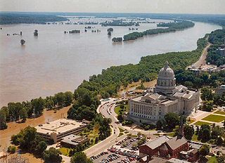
The Great Flood of 1993 was a flood that occurred in the Midwestern United States, along the Mississippi and Missouri rivers and their tributaries, from April to October 1993.

The Central United States is sometimes conceived as between the Eastern and Western as part of a three-region model, roughly coincident with the U.S. Census's definition of the Midwestern United States plus the western and central portions of the U.S. Census's definition of the Southern United States. The Central States are typically considered to consist of North Dakota, South Dakota, Nebraska, Kansas, Oklahoma, Texas, Minnesota, Iowa, Missouri, Arkansas, Louisiana, Wisconsin, Illinois, Michigan, Indiana, Ohio, Kentucky, Tennessee, West Virginia, Mississippi and Alabama.
The timeline of Kansas details past events that happened in what is present day Kansas. Located on the eastern edge of the Great Plains, the U.S. state of Kansas was the home of sedentary agrarian and hunter-gatherer Native American societies, many of whom hunted American bison. The region first appears in western history in the 16th century at the time of the Spanish conquest of the Aztec Empire, when Spanish conquistadors explored the unknown land now known as Kansas. It was later explored by French fur trappers who traded with the Native Americans. It became part of the United States in the Louisiana Purchase of 1803. In the 19th century, the first American explorers designated the area as the "Great American Desert."
The history of the U.S. state of Nebraska dates back to its formation as a territory by the Kansas–Nebraska Act, passed by the United States Congress on May 30, 1854. The Nebraska Territory was settled extensively under the Homestead Act of 1862 during the 1860s, and in 1867 was admitted to the Union as the 37th U.S. state. The Plains Indians are the descendants of a long line of succeeding cultures of indigenous peoples in Nebraska who occupied the area for thousands of years before European arrival and continue to do so today.
The history of South Dakota describes the history of the U.S. state of South Dakota over the course of several millennia, from its first inhabitants to the recent issues facing the state.

The Missouri River Valley outlines the journey of the Missouri River from its headwaters where the Madison, Jefferson and Gallatin Rivers flow together in Montana to its confluence with the Mississippi River in the State of Missouri. At 2,300 miles (3,700 km) long the valley drains one-sixth of the United States, and is the longest river valley on the North American continent. The valley in the Missouri River basin includes river bottoms and floodplains.
The Great Flood of 1881 was along the Missouri River between April 1, 1881, and April 27, 1881. The flood began around Pierre, South Dakota and struck areas down river in Yankton, South Dakota, Omaha, Nebraska, Council Bluffs, Iowa, Nebraska City, Nebraska, Kansas City, Missouri, and farther south. This was the first detailed reporting of Missouri River flooding, and caused millions of dollars in damage.