
Arthington is a linear village in Wharfedale, in the City of Leeds metropolitan borough in West Yorkshire, England. It is a civil parish which, according to the 2011 census, had a population of 532. It is in the Otley ward of the City of Leeds, and the Leeds North West parliamentary constituency.

Geoffrey Anketell Studdert Kennedy was an English Anglican priest and poet. He was nicknamed "Woodbine Willie" during World War I for giving Woodbine cigarettes to the soldiers he met, as well as spiritual aid to injured and dying soldiers.

Sir William Robertson Nicoll was a Scottish Free Church minister, journalist, editor, and man of letters.

Arthur Henry Mee was an English writer, journalist and educator. He is best known for The Harmsworth Self-Educator, The Children's Encyclopædia, The Children's Newspaper, and The King's England.

Philip Guedalla was an English barrister, and a popular historical and travel writer and biographer. His wit and epigrams are well-known, one example being "Even reviewers read a Preface". He also was the originator of a now-common theory on Henry James, writing that "The work of Henry James has always seemed divisible by a simple dynastic arrangement into three reigns: James I, James II, and the Old Pretender."
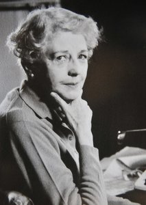
Norah Lofts, néeNorah Ethel Robinson, was a 20th-century British writer. She also wrote under the pen names Peter Curtis and Juliet Astley. She wrote more than fifty books specialising in historical fiction, but she also wrote some mysteries, short stories and non-fiction. Many of her novels, including her Suffolk Trilogy, follow the history of specific houses and their residents over several generations.
Hodder & Stoughton is a British publishing house, now an imprint of Hachette.
Rosemary Sassoon is an expert in handwriting, particularly that of children. She designed the Sassoon series of typefaces, produced in collaboration with Adrian Williams, which are intended to be particularly legible for children and learners.

Skyrack was a wapentake of the West Riding of Yorkshire, England. It was split into upper and lower divisions and centred in Headingley, Leeds. The Lower Division included the parishes of Aberford, Bardsey, Barwick-in-Elmet, Kippax, Thorner, Whitkirk and part of Harewood, while the Upper Division included the parishes of Adel, Bingley, Guiseley and parts of Harewood, Ilkley and Otley.

Great Hale is a village and civil parish in the North Kesteven district of Lincolnshire, England. The population of the civil parish at the 2011 census was 778. It is situated on the B1394 road, immediately south from Heckington and 1.7 miles (2.7 km) north from Helpringham.

Church Fenton is a village and civil parish in the North Yorkshire district of North Yorkshire, England. It is about 16 miles (26 km) east of Leeds, about 6 miles (10 km) south-east from Tadcaster and 3 miles (5 km) north from Sherburn in Elmet. Neighbouring villages include Barkston Ash, Cawood and Ulleskelf. The former RAF Church Fenton is located immediately north-east, which is now known as Leeds East Airport.
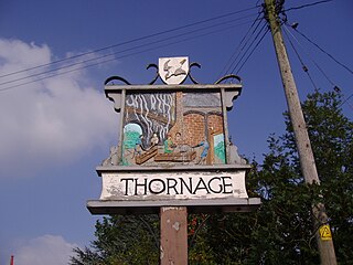
Thornage is a village and a civil parish in the English county of Norfolk. The village is 2.7 miles south-west of Holt, 23.2 miles north-west of Norwich and 11.3 miles east of Fakenham, and straddles the B1110 road between Holt and Guist. The nearest railway station is at Sheringham for the Bittern Line which runs between Sheringham, Cromer and Norwich. The nearest airport is at Norwich International Airport.
The Pevsner Architectural Guides are four series of guide books to the architecture of the British Isles. The Buildings of England series was begun in 1945 by the art historian Sir Nikolaus Pevsner, with its forty-six original volumes published between 1951 and 1974. The fifteen volumes in The Buildings of Scotland series were completed between 1978 and 2016, and the ten in The Buildings of Wales series between 1979 and 2009. The volumes in all three series have been periodically revised by various authors; Scotland and Wales have been partially revised, and England has been fully revised and reorganised into fifty-six volumes. The Buildings of Ireland series was begun in 1979 and remains incomplete, with six of a planned eleven volumes published. A standalone volume covering the Isle of Man was published in 2023.
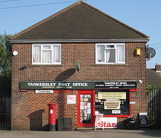
Tankersley is a village and civil parish in the Metropolitan Borough of Barnsley in South Yorkshire, England. At the 2001 census it had a population of 1,414, increasing to 1,671 at the 2011 Census.

Hartley Wespall is a civil parish in the Basingstoke and Deane district of Hampshire, England. It is near the larger village of Hook, which lies approximately 2.5 miles (4.1 km) south-west from the hamlet.

Hurstbourne Priors is a small village and civil parish in the Basingstoke and Deane district of Hampshire, England. Its nearest town is Whitchurch, which lies approximately 1.8 miles (3.1 km) north-east from the village.

Uplowman is a village and civil parish in the Mid Devon district, in Devon, England, situated about 4 miles north-east of the town of Tiverton. The parish is surrounded, clockwise from the north, by the parishes of Hockworthy, Sampford Peverell, Halberton, Tiverton, and Huntsham. It is situated near the River Lowman, and further downstream, to the west, is Crazelowman. In 2011 the parish had a population of 331.

Foster Powell was the first notable exponent of long-distance walking known as pedestrianism and has been called "the first English athlete of whom we have any record". Powell started the focus on walking/running for six days and is considered the “Father of the Six-Day Race.”
The Church of St Ricarius, Aberford, West Yorkshire, England, is an active Anglican parish church in the archdeaconry of York and the Diocese of Leeds. It is commonly stated that the dedication refers to the French saint St Richarius or Riquier who is supposed to have visited Aberford in 630. However, the church itself has a stained glass window depicting "Ricarius Rex 720" the Saxon King also known as St Richard the Pilgrim.

Boothferry Bridge is a crossing over the River Ouse, in the East Riding, England, some 2 miles (3.2 km) north-west of Goole. The bridge was opened in 1929, replacing a ferry crossing immediately west of the bridge's location. The Act of Parliament for the building of the bridge in 1925, gave priority to river traffic. This situation still exists, though there have been some attempts to change priorities. On opening, it was the furthest crossing downstream of the river, cutting 25 miles (40 km) off the journey south to London from Kingston upon Hull. The M62 Ouse Bridge opened up to the east of Boothferry Bridge in 1976.

