The Langtons

Last updated

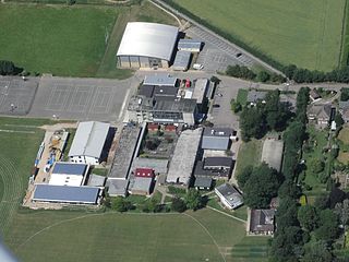
The Langtons is an area of Harborough, Leicestershire, England comprising the following villages:

Harborough District District in England

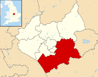
Harborough is a local government district of Leicestershire, England, named after its main town, Market Harborough. Covering 230 square miles (600 km2), the district is by far the largest of the eight district authorities in Leicestershire and covers almost a quarter of the county.

Leicestershire County of England

Leicestershire is a landlocked county in the English Midlands. The county borders Nottinghamshire to the north, Lincolnshire to the north-east, Rutland to the east, Northamptonshire to the south-east, Warwickshire to the south-west, Staffordshire to the west, and Derbyshire to the north-west. The border with most of Warwickshire is Watling Street.

England Country in north-west Europe, part of the United Kingdom

England is a country that is part of the United Kingdom. It shares land borders with Wales to the west and Scotland to the north. The Irish Sea lies west of England and the Celtic Sea to the southwest. England is separated from continental Europe by the North Sea to the east and the English Channel to the south. The country covers five-eighths of the island of Great Britain, which lies in the North Atlantic, and includes over 100 smaller islands, such as the Isles of Scilly and the Isle of Wight.

East Langton a village located in Harborough, United Kingdom

East Langton is a village and civil parish in the Harborough district of Leicestershire, England.

Thorpe Langton human settlement in United Kingdom

Thorpe Langton is a village and civil parish in the Harborough district of Leicestershire, about four miles north of Market Harborough. The parish had a population of 171 according to the 2001 census. Ten years later, in the 2011 census, the population had grown to 200. Thorpe Langton is the home of the Baker's Arms pub and St. Leonard's church, but is otherwise solely residential.

Tur Langton human settlement in United Kingdom

Tur Langton is a small village and civil parish in the Harborough district, in the heart of Leicestershire in England. Tur Langton is home to St Andrews Church and The Crown Inn, situated in the centre of the village. The next nearest settlement of significant size is the civil parish Kibworth Harcourt, found approximately 2 km west of Tur Langton. According to the 2011 census, Tur Langton had a population of 316.

Coordinates: 52°31′37″N0°55′48″W / 52.527°N 0.930°W / 52.527; -0.930

Geographic coordinate system Coordinate system

A geographic coordinate system is a coordinate system that enables every location on Earth to be specified by a set of numbers, letters or symbols. The coordinates are often chosen such that one of the numbers represents a vertical position and two or three of the numbers represent a horizontal position; alternatively, a geographic position may be expressed in a combined three-dimensional Cartesian vector. A common choice of coordinates is latitude, longitude and elevation. To specify a location on a plane requires a map projection.


Related Research Articles

Gartree was a hundred of Leicestershire.

Langton, County Durham village in United Kingdom

Langton is a village and civil parish in County Durham, in England. It is situated to the west of Darlington, near Headlam and Ingleton. The population of the civil Parish taken at the 2011 Census was less than 100. Information is contained in the parish of Ingleton, County Durham.

Great Bowden a village located in Harborough, United Kingdom

Great Bowden is a village and civil parish in the Harborough district of Leicestershire, England. It is north-east of and a suburb of Market Harborough, although originally the parish of Great Bowden included Harborough. The population is around 1,000, being measured at the 2011 census as 1,017. It is the site of Great Bowden Hall.

West Langton human settlement in United Kingdom

West Langton is a civil parish in the Harborough district of Leicestershire, England. The main settlement in the parish is Langton Hall

The Langton Foundation, grammar school in Canterbury, Kent, England

The Langton Grammar School for Boys is an English school of over 1,300 pupils and staff, located on the outskirts of Canterbury, Kent. It holds both foundation and grammar school status. Its sister school is Simon Langton Girls' Grammar School. It is situated on the B2068 towards the Canterbury bypass, south of the city. Students from all over East Kent, within nine miles of the school, typically join the school in Year 7 and can then stay on until GCSE examinations in Year 11. However, the majority of students decide to stay on into the sixth form. The lower school is boys-only and the sixth form is mixed-sex.

Nissan MA engine

The MA is a straight-4 SOHC 0.9 L, 1.0 L, or 1.2 L engine introduced in 1982 by Nissan, intended primarily for the K10 series Micra/March model. It shares design similarities with the older E engine, with an 8-valve hemispherical cylinder head but differs in that it uses an aluminium cylinder block. Unusually, the specified ignition timing for the MA10 running on the specified 90 RON gasoline was 2 degrees after top dead centre, reflecting a very high flame speed in the compact combustion chambers.

Langton is a small town located in Norfolk County; formerly known as Boughner's Corner.

The MSU Pavilion for Agriculture and Livestock Education is a convention center located in East Lansing, Michigan on the campus of Michigan State University. It was built in 1996. It has 101,527 square feet (9,432 m2) of exhibit space.

East Langton railway station

East Langton railway station was opened by the Midland Railway on what is now the Midland Main Line, initially calling it simply Langton.

Kagamil Island mountain


Kagamil Island, in the Islands of Four Mountains subgroup of the Aleutian archipelago, is 3.7 miles (6.0 km) north of Chuginadak Island and 1.2 miles (1.9 km) south of Uliaga Island. It is 6.2 miles (10.0 km) in length and up to 3.1 miles (5.0 km) in width. The southern half of the island is dominated by the Kagamil Volcano, which has two summits: one is 2,930 feet (890 m) above sea level, while the other is lower at 2,260 feet (690 m).

A158 road road in England

The A158 road is a major tourist route that heads from Lincoln in the west to Skegness on the east coast. The road is located entirely in the county of Lincolnshire and is single carriageway for almost its entirety. The road is approximately 41 miles (66 km) long. The road gets quite congested with holiday traffic during the summer.

Fielders Sports Ground is a cricket ground in Hornchurch, England. It was formerly part of the grounds of Langtons House and was known as Langton Park when it was a first-class cricket ground.

Bullington Priory

Bullington Priory was a priory in Bullington, Lincolnshire, England.

Cathedral Close, Lichfield Residential area in Staffordshire, UK

The Cathedral Close is a historic set of buildings surrounding Lichfield Cathedral in Lichfield in the United Kingdom. The Close comprises buildings associated with the cathedral and the clergy which encircle the Cathedral. The Close grew up around the cathedral during medieval times and today some medieval buildings remain in the Close but the majority of buildings date from the seventeenth, eighteenth and nineteenth centuries.

Camp Edmunds is a former Massachusetts State Militia camp that existed in 1856 in Salem, Massachusetts on Winter Island.

German submarine <i>U-930</i> German WWII submarine

German submarine U-930 was a Type VIIC/41 U-boat of Nazi Germany's Kriegsmarine during World War II.

Glantwymyn

Glantwymyn is a community in the northwest (Montgomeryshire) of Powys, Wales.

Beetley and Hoe Meadows

Beetley and Hoe Meadows is an 11.4-hectare (28-acre) biological Site of Special Scientific Interest north of Dereham in Norfolk. The site is in two nearby areas, and Hoe Meadow is part of Hoe Rough nature reserve, which is managed by the Norfolk Wildlife Trust

Potter and Scarning Fens, East Dereham

Potter and Scarning Fens, East Dereham is a 6.2-hectare (15-acre) biological Site of Special Scientific Interest south of Dereham in Norfolk. It is part of the Norfolk Valley Fens Special Area of Conservation. Scarning Fen is a Nature Conservation Review site, Grade I, and it is managed by the Norfolk Wildlife Trust.

National Cycle Route 64

National Cycle Network (NCN) Route 64 is a Sustrans National Route that runs from Market Harborough to Lincoln. The route is 68 miles (109 km) in length and is fully open and signed in both directions. There are three sections to the route, NCN 63 and NCN 15 form the links between these sections.