The Charlotte Area Transit System (CATS) is the agency responsible for public transportation in the Charlotte metropolitan area. CATS operates bus and rail transit services in Mecklenburg County and surrounding areas. Established in 1999, CATS' bus and rail operations carry about 320,000 riders on an average week. CATS is governed by the Metropolitan Transit Commission and is operated as a department of the City of Charlotte. In 2023, the system had a ridership of 13,476,600, or about 40,900 per weekday as of the first quarter of 2024.

Uptown Charlotte, also called Center City, is the central business district of Charlotte, North Carolina, United States. The area is split into four wards by the intersection of Trade and Tryon Streets, and bordered by Interstate 277 and Interstate 77. The area is managed and overseen by the Charlotte Central City Partners, which is one of the three Municipal Service Districts in Charlotte. Uptown Charlotte is the largest business district in Charlotte and the Carolinas.

The Charlotte Trolley was a heritage streetcar that operated in Charlotte in the U.S. state of North Carolina. The line ran along the former Norfolk Southern right of way between Tremont Avenue in the Historic South End in a northerly direction to its terminus at 9th Street Uptown. It ran on tracks mostly shared with the LYNX Blue Line.

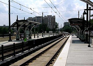
7th Street station is a light rail station for the LYNX Blue Line in Center City Charlotte, North Carolina, United States. It is located between 6th and 7th Streets; several privately operated parking decks and lots surround the station. Notable places nearby include Discovery Place, Hearst Tower, ImaginOn, Levine Museum of the New South, Main Public Library and the McGlohon Theatre at Spirit Square.

The Charlotte Transportation Center (CTC), also known as Arena or CTC/Arena, is an intermodal transit station in Center City Charlotte, North Carolina, United States. It serves as the central hub for the Charlotte Area Transit System (CATS) buses and connects with the LYNX Blue Line and CityLYNX Gold Line. It is located on East Trade Street, Fourth Street and Brevard Street. Notable places nearby include the Bank of America Corporate Center, Belk Theater, EpiCentre, Overstreet Mall and the Spectrum Center.
Brooklyn Village, formerly Stonewall, is a light rail station in Charlotte, North Carolina. The elevated dual side platforms are a stop along the Lynx Blue Line in Uptown Charlotte.

I-485/South Boulevard is a light rail station in Charlotte, North Carolina. The elevated island platform is the southern terminus stop along the Lynx Blue Line and includes the second largest park and ride operated by Charlotte Area Transit System (CATS). Serving both Carolina Pavilion and Sterling neighborhood in the immediate area, it also serves commuters from Pineville, Ballantyne, and the South Carolina border towns.
Carson is a light rail station in Charlotte, North Carolina. The at-grade dual side platforms are a stop along the Lynx Blue Line and serves the South End neighborhood.

Bland Street is a light rail station in Charlotte, North Carolina, United States. The at-grade dual side platforms are a stop along the Lynx Blue Line and serves South End and nearby Dilworth neighborhood.

East/West Boulevard is a light rail station in Charlotte, North Carolina. The at-grade dual side platforms are a stop along the Lynx Blue Line and serves South End and nearby Dilworth and Wilmore neighborhoods.

Woodlawn is a light rail station in Charlotte, North Carolina. The at-grade dual side platforms are a stop along the Lynx Blue Line and serves an area of mostly commercial and industrial businesses, with the neighborhoods of Collingwood and Madison Park located nearby. It also features a 382-space park and ride and local bus connections.

9th Street is a light rail station in Charlotte, North Carolina. The at-grade dual side platforms are a stop along the Lynx Blue Line and serves Uptown Charlotte's First Ward as well as First Ward Park and the UNC Charlotte Center City Campus.

Morehead was a heritage streetcar station in Charlotte, North Carolina. The at-grade side platforms, located below Morehead Street, was a stop for the Charlotte Trolley in the South End neighborhood.

Atherton Mill was a heritage streetcar station in Charlotte, North Carolina. The former at-grade side platform was located in front of the Trolley Barn at Atherton Mill and it had served as the southern terminus of the Charlotte Trolley, which connected South End to Uptown Charlotte.
Transportation in the city of Charlotte, North Carolina includes a large and growing mass transit and rail system, a major international airport, and several controlled-access highways.

Charlotte Gateway Station is a future intermodal transit station in Charlotte, North Carolina, United States. Currently operating as a streetcar stop for the CityLynx Gold Line, with an adjoining bus station for Greyhound Lines intercity buses, it is the centerpiece of the overall 19-acre (7.7 ha) Station District, and it will serve Charlotte Area Transit System (CATS) bus lines, the Lynx Silver Line light rail, Amtrak intercity trains. The district will also include parking facilities, mixed-use development and an elevated greenway. Estimated at a cost of $800.1 million for full implementation of all public and private components, the project will be built in three phases, with Amtrak service tentatively scheduled to start in 2026–2027.

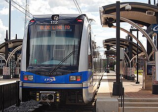
The Lynx Blue Line is a light rail line in Charlotte, North Carolina, United States. Opened in 2007, it was the first rail line of the Charlotte Area Transit System, and the first major rapid rail service of any kind in the state. The 26-station, 19.3-mile (31.1 km) line extends from its northern terminus at the University of North Carolina at Charlotte in University City through NoDa, Uptown, and South End, then runs along South Boulevard to its southern terminus just north of Interstate 485 at the Pineville city limits. The line carries an average of over 27,700 passenger trips every day and offers connections to the CATS' CityLynx Gold Line which opened in 2015.

Parkwood is a light rail station on the LYNX Blue Line in the Optimist Park neighborhood of Charlotte, North Carolina, United States. It opened on March 16, 2018, as part of the Blue Line extension to the UNC Charlotte campus. The station features a pair of side platforms and is the first station outside of Uptown Charlotte to the north.

University City Blvd is a light rail station on the LYNX Blue Line in Charlotte, North Carolina, United States. It is located on North Tryon Street and Periwinkle Hill Avenue in University City. The station consists of a single island platform in the street's median, connected to an adjacent parking garage by a pedestrian overpass. The parking garage charges a flat weekday fee for all riders that do not have a one-day, weekly or monthly pass. Notable places nearby include the Belgate Shopping Center, IKEA and the Wells Fargo Customer Information Center (CIC). The station opened on March 16, 2018.

Tryon Street is a streetcar station in Charlotte, North Carolina. The at-grade dual side platforms on West Trade Street are a stop along the CityLynx Gold Line, serving Independence Square and the second largest financial hub of the United States.

