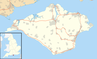
The Isle of Wight is a county and the largest and second-most populous island in England. It is in the English Channel, between 2 and 5 miles off the coast of Hampshire, separated by the Solent. The island has resorts that have been holiday destinations since Victorian times, and is known for its mild climate, coastal scenery, and verdant landscape of fields, downland and chines.
Horseshoe Bay may refer to:

Totland is a village, civil parish and electoral ward on the Isle of Wight. Besides the village of Totland, the civil parish comprises the western tip of the Isle of Wight, and includes The Needles, Tennyson Down and the hamlet of Middleton.

Newtown Bay is a bay on the northwestern coast of the Isle of Wight, England in the western arm of the Solent. It is a subtle bay located around the exit of the Newtown River. It stretches about 4 km from Hamstead Point in the west to Salt Mead Ledge to the east. It is a remote place as there are few properties along this part of the coast, it being low-lying marshland and home to countless sea birds, and is often visited by walkers, boaters, birdwatchers and beachcombers. The shore is a narrow band of gravel, while the sea bottom is mostly mud or sand.

Lake is a large village and civil parish located on Sandown Bay, on the Isle of Wight, England. It is six miles south-east of Newport situated between Sandown and Shanklin, and 1 1⁄2 miles (2.4 km) to the east of the hamlet of Apse Heath.

Apse Heath is a hamlet on the Isle of Wight, UK. Apse Heath is centered on the intersection of Newport Road and Alverstone Road. At the 2011 Census the Post Office said the population of the hamlet was included in the civil parish of Newchurch, Isle of Wight.
It is northeast of Whiteley Bank and south of Winford. Apse Heath is bordered by the leafy villages of Alverstone and Queen's Bower, and is surrounded by areas of woodland and agricultural land. It also sits roughly 2 miles east of the village of Newchurch, and 1 mile west of Lake.

Afton is a hamlet just outside Freshwater on the west side of the Isle of Wight. It features a local hill known as Afton Down which was the site of the Isle of Wight Festival in 1970, one of the largest rock concerts to be held in the UK. Freshwater Bay Golf Course is located on Afton Down. Afton lends its name to a number of local properties, including Afton Lodge, Afton Manor and Afton Thatch, the latter two dating from the 17th Century.

Nettlecombe is a farming hamlet on the Isle of Wight. It is the site of a deserted medieval village and there is evidence of earthworks close to the present hamlet.
There are several fishing lakes in Nettlecombe.
Borthwood is a hamlet on the Isle of Wight, adjacent to Borthwood Copse, the National Trust woodland. Borthwood includes some holiday cottages and a pet kennel. At the 2011 Census the Post Office specified that the population of the hamlet was included in the civil parish of Newchurch, Isle of Wight.

Bierley is a hamlet on the Isle of Wight, UK. Bierley is in the south of the Isle of Wight, north of Niton and 0.7 miles to the west of Whitwell. Bierley is at the corner of Kingates Lane and Newport Road.
Hale Common is a farming hamlet on the Isle of Wight. Hale Common is on the A3056 road between Lake and Arreton. Hale Common is northeast of Bathingbourne and northwest of Branstone. It is in the civil parish of Godshill.
Isle of Wight Bay is a lagoon that separates part of mainland Worcester County, Maryland from the midtown part of Ocean City, also in Worcester County. To the north, it connects to the Assawoman Bay just south of the Assawoman Bay Bridge, and to the south it connects to the Sinepuxent Bay at the north end of West Ocean City where the bay narrows between the Thoroughfare channel and Mallard Island. The major tributary of Isle of Wight Bay is the St. Martin's River; other tributaries include Turville Creek, Manklin Creek, and Herring Creek.

The Isle of Wight Coastal Path is a circular long-distance footpath of 70 miles (113 km) around the Isle of Wight, UK. It follows public footpaths and minor lanes, with some sections along roads.

Brook Chine is a geological feature on the south west coast of the Isle of Wight, England. It lies just to the west of the village of Brook. The hamlet of Brookgreen runs along its southern edge.

Chilton Chine is a geological feature on the south west coast of the Isle of Wight, England. It lies to the west of the village of Brighstone. It is a small coastal gully, one of a number of such chines on the island created by stream erosion of soft Cretaceous rocks.

Grange Chine and Marsh Chine form a geological feature on the south west coast of the Isle of Wight, England. They lie to the south of the village of Brighstone.

Brook Bay is a bay on the south western coast of the Isle of Wight, England. It lies to the west of the village of Brook. It faces south west out into the English Channel. It stretches about 2km from Hanover Point in the east to Sudmoor Point to the west. Much of the surrounding land, including the hamlet of Brookgreen is owned by the National Trust.

Thorncross is a small hamlet in the South West of the Isle of Wight, England.. It is located near the hamlet of Yafford and the village of Brighstone.


