
Fiordland National Park occupies the southwest corner of the South Island of New Zealand. It is by far the largest of the 13 national parks in New Zealand, with an area of 12,607 square kilometres (4,868 sq mi), and a major part of the Te Wahipounamu World Heritage Site. The park is administered by the Department of Conservation.

Kōkako are two species of forest bird in the genus Callaeas which are endemic to New Zealand, the endangered North Island kōkako and the presumed extinct South Island kōkako. They are both slate-grey with wattles and have black masks. They belong to a family containing five species of New Zealand wattlebirds, the other three being two species of tieke (saddleback) and the extinct huia. Previously widespread, kōkako populations throughout New Zealand have been decimated by the predations of mammalian invasive species such as possums, stoats, cats and rats, and their range has contracted significantly. In the past this bird was called the New Zealand crow. It is not closely related to the crow, but looks like one from a distance.

Moutohora Island is a small uninhabited island located off the Bay of Plenty coast of New Zealand's North Island, about 9 kilometres (5.6 mi) north of the town of Whakatane. The 1.43 km2 (0.55 sq mi) island is a remnant of a complex volcano which has eroded, leaving two peaks. This is still an area of volcanic activity and there are hot springs on the island in Sulphur Valley, McEwans Bay, and Sulphur Bay.

The Whanganui River is a major river in the North Island of New Zealand. It is the country's third-longest river, and has special status owing to its importance to the region's Māori people. In March 2017 it became the world's second natural resource to be given its own legal identity, with the rights, duties and liabilities of a legal person. The Whanganui Treaty settlement brought the longest-running litigation in New Zealand history to an end.

The saddlebacks are two species of New Zealand bird of the family Callaeidae. Both are glossy black with a chestnut saddle. Its taxonomic family is also known as that of the "wattlebirds" and includes the two species of kōkako, as well as the extinct huia. All members of the family Callaeidae have coloured fleshy appendages on either side of the beak, known as wattles; Saddlebacks' wattles are a vivid red.
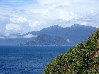
Chalky Island or Te Kākahu-o-Tamatea is an island in the southwest of New Zealand, and is part of Fiordland National Park. It lies at the entrance to Taiari / Chalky Inlet, next to Rakituma / Preservation Inlet, at the southwestern tip of the South Island, 10 kilometres (6 mi) northwest of Puysegur Point, 15 kilometres (9 mi) southeast of West Cape, and 140 kilometres (87 mi) west of Invercargill.

Anchor Island is an island in Dusky Sound in Fiordland.

Rotoroa Island is an island to the east of Waiheke Island in the Hauraki Gulf of New Zealand. It covers 82 hectares. The Salvation Army purchased it for £400 in 1908 from the Ruthe family to expand their alcohol and drug rehabilitation facility at nearby Pakatoa Island. Men were treated at Home Bay at Rotoroa, while women were treated at Pakatoa. This treatment facility was closed in 2005.

The Whanganui Journey is a river journey along the Whanganui River in the North Island of New Zealand travelling by canoe or kayak. The route, starting at Taumarunui and finishing at Pipiriki, is 145 km long and usually takes 5 days to complete. The route is managed by New Zealand's Department of Conservation under its Great Walks programme, and much of the route travels through land which is part of the Whanganui National Park.

A wattle is a fleshy caruncle hanging from various parts of the head or neck in several groups of birds and mammals. Caruncles in birds include those found on the face, wattles, dewlaps, snoods, and earlobes. Wattles are generally paired structures, but may occur as a single structure when it is sometimes known as a dewlap. Wattles are frequently organs of sexual dimorphism. In some birds, caruncles are erectile tissue and may or may not have a feather covering.

Tieke Kāinga is a small Māori community in New Zealand, on the middle reaches of the Whanganui River 2.5 kilometres (1.6 mi) downstream from the mouth of the Mangatiti Stream. It is centred on Tieke Marae, a converted Department of Conservation tramping hut. The surrounding land is subject to a Māori land claim which began with occupation of the hut in 1993.
Breaksea Island is a rugged 1.6 km2 (1 sq mi) island in the southwest of New Zealand, and is part of Fiordland National Park. Its highest point is 350 m (1,148 ft) asl and it lies about 2 km (1.2 mi) from the mainland in the entrance to Te Puaitaha / Breaksea Sound, north of the much larger Resolution Island. It is covered in temperate rainforest and was the site of one of the first successful campaigns to eradicate rats from a sizeable island.
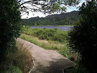
Lake Rotokare is a landslide dammed lake in the New Zealand region of Taranaki. It is located 12 km (7.5 mi) east of Eltham.
Bushy Park is a forest located on the west coast of the North Island of New Zealand, at 791 Rangitatau East Road, 8 kilometres (5.0 mi) from Kai Iwi, Whanganui, Manawatū-Whanganui region. It features an Edwardian-era homestead, which is a Category I heritage building registered with Heritage New Zealand, a predator-free native bird sanctuary, and a virgin rainforest. It measures approximately 100 hectares, and is characterized as a "lowland remnant of rata-podocarp taka-puketea [sic] rainforest". According to Forest & Bird, Bushy Park is considered to be amongst the 25 best restoration ecology projects in Australia and New Zealand.
Akuaku, also known as Aku Aku, was a settlement approximately halfway between Waipiro Bay and Whareponga in the East Coast region of New Zealand's North Island. A traditional landing point for waka taua, the town is most notable now as the former home of Major Ropata Wahawaha, N.Z.C, as well as the ancestral home of Te Whānau-a-Rākairoa.

The North Island saddleback is a forest-dwelling passerine bird species endemic to the North Island of New Zealand. It was once considered conspecific with the South Island saddleback. The IUCN lists the species as Near Threatened, while it is listed as a "recovering" species in the New Zealand Threat Classification System. Saddlebacks are known in Māori as tīeke.

Bauza Island lies immediately south of the much larger Secretary Island in the outer reaches of Doubtful Sound / Patea, in Fiordland National Park on New Zealand's South Island. The less than one kilometre wide Patea passage to the south of the island is the main entrance to Doubtful Sound. To the north, the island is separated from Secretary Island by the narrow Te Awaatu Channel, also referred to as "The Gut", only 200 metres (660 ft) wide at its narrowest point. The waters between the two islands are protected by the Te Awaatu Channel Marine Reserve. Doubtful Sound tour boats routinely travel through this channel.
Anna Tieke was a German communist. With her family she relocated to the Soviet Union in 1931. On 15 January 1938 Anna Tieke and her son Rudolf, identified as "suspected German spies", were shot and killed in Leningrad. Formal "rehabilitation" came posthumously, in 1956.
Parinui is a small Māori community in New Zealand, based around the Mangatiti Stream on the middle reaches of the Whanganui River. The area, including the neighbouring settlement of Tieke Kāinga, is popular with tourists.