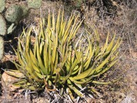
The Lechuguilla Desert is a small desert located in southwestern Arizona near the U.S.-Mexico border. It is considered to be part of the Lower Colorado Valley region of the Sonoran Desert. It lies in a north-south direction between the Gila Mountains and the Cabeza Prieta Mountains, and almost entirely in the Barry M. Goldwater Air Force Range. The desert is named after the Lechuguilla plant, known scientifically as Agave lecheguilla which according to the Wikipedia entry for that occurs exclusively in the Chihuahuan desert many hundreds of miles to the east. The desert is also on the north border of the Gran Desierto de Altar of Sonora, Mexico.

A plunge pool is a deep depression in a stream bed at the base of a waterfall or shut-in. It is created by the erosional forces of cascading water on the rocks at formation's base where the water impacts. The term may refer to the water occupying the depression, or the depression itself.

Zetaquirá is a town and municipality in the Colombian Lengupá Province, part of the department of Boyacá. Zetaquirá is located at 67 kilometres (42 mi) from the department capital Tunja and borders Pesca in the north, Miraflores in the south, in the east Berbeo, San Eduardo and Aquitania and in the west Ramiriquí and Chinavita. The municipality stretches over an area of 262 square kilometres (101 sq mi) on the Altiplano Cundiboyacense at altitudes between 1,875 metres (6,152 ft) and 3,600 metres (11,800 ft).
Tinajas is a municipality located in the province of Cuenca, Castile-La Mancha, Spain. According to the 2004 census (INE), the municipality has a population of 370 inhabitants.
The Copper Mountains is a minor north-south trending mountain range, only 8 miles long in southwestern Arizona in the southwestern Sonoran Desert.

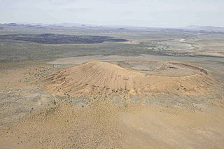
The Tinajas Altas Mountains are an extremely arid northwest-southeast trending mountain range in southern Yuma County, Arizona, approximately 35 mi southeast of Yuma, Arizona. The southern end of the range extends approximately one mile into the northwestern Mexican state of Sonora on the northern perimeter of the Gran Desierto de Altar. The range is about 22 mi in length and about 4 mi wide at its widest point. The highpoint of the range is unnamed and is 2,766 feet above sea level and is located at 32°16'26"N, 114°02'48"W. Aside from the portion of the range in Mexico, the entirety of the range lies within the Barry M. Goldwater Air Force Range. They lie at the heart of the traditional homeland of the Hia C-eḍ O'odham people.

The Gila Mountains of Yuma County are a 26-mile (42 km) long mountain range in southwestern Arizona in the northwest Sonoran Desert.

The Tiszapolgár culture or Tiszapolgár-Româneşti culture was an Eneolithic archaeological culture of the Great Hungarian Plain, the Banat, Eastern Slovakia and Ukrainian Zakarpattia Oblast in Central Europe.

Durango is one of the 39 municipalities of Durango, in north-western Mexico. The municipal seat lies at Durango. The municipality covers an area of 10,041 km².

Dolega District is a district (distrito) of Chiriquí Province in Panama. The population according to the 2000 census was 17,243.The district covers a total area of 249 km². The capital lies at the city of Dolega.

El Camino del Diablo is a historic 250-mile (400 km) road that currently extends through some of the most remote and arid terrain of the Sonoran Desert in Pima County and Yuma County, Arizona. In use for at least 1,000 years, El Camino del Diablo is believed to have started as a series of footpaths used by desert-dwelling Native Americans. From the 16th to the 19th centuries, the road was used extensively by conquistadores, explorers, missionaries, settlers, miners, and cartographers. Use of the trail declined sharply after the railroad reached Yuma in 1870. In recognition of its historic significance, El Camino del Diablo was listed on the National Register of Historic Places in 1978. It has also been designated a Bureau of Land Management Back Country Byway.

Moreno Department is a department of Santiago del Estero Province, Argentina. The capital lies at Quimilí.
Tinaja is a term originating in the American Southwest for surface pockets (depressions) formed in bedrock that occur below waterfalls, are carved out by spring flow or seepage, or are caused by sand and gravel scouring in intermittent streams (arroyos). Tinajas are an important source of surface water storage in arid environments.
El Pinacate y Gran Desierto de Altar Biosphere Reserve, is a biosphere reserve and UNESCO World Heritage Site managed by the Federal government of Mexico, specifically by Secretariat of the Environment and Natural Resources, in collaboration with state government of Sonora and the Tohono O'odham.

Las Tinajas de Los Indios, or "Indian Tanks", are tinajas located in the sandstone heights of the Point of Rocks on the north side of Antelope Valley in Kern County, California.
Federal Highway 145 is a Federal Highway of Mexico. The highway travels from La Tinaja, Veracruz in the north to Sayula, Veracruz in the south.
Tinajas is a corregimiento in Dolega District, Chiriquí Province, Panama. It has a land area of 29.4 square kilometres (11.4 sq mi) and had a population of 1,530 as of 2010, giving it a population density of 52 inhabitants per square kilometre (130/sq mi). Its population as of 1990 was 1,084; its population as of 2000 was 1,237.
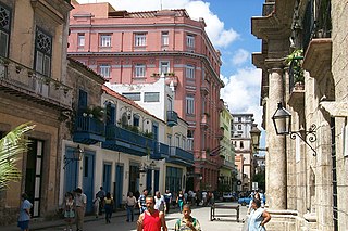
The Obispo Street is one of the most famous and traveled streets of Havana Vieja. During its history it has received several denominations like: San Juan, Of the Bishop, Weyler, Pi Margall, among others, for a total of 47. It is the longest Boulevard in Havana. Street shops have always been abundant alongside O'Reilly Street, which is parallel to it from its inception in Zulueta to Havana Bay.
Federal Highway 145D is a toll highway in the state of Veracruz. It connects southern Veracruz to Mexican Federal Highway 150D, continuing the other road's east-west trajectory. The road is operated by Caminos y Puentes Federales, who charges a toll of 183 pesos per car to travel Highway 145D.
Tinajas Altas Pass is a gap in the Tinajas Altas Mountains in Yuma County, Arizona. Its highest elevation is at 1,106 feet / 337 meters.