This page is based on this
Wikipedia article Text is available under the
CC BY-SA 4.0 license; additional terms may apply.
Images, videos and audio are available under their respective licenses.
Triangle is a town in Broome County, New York, United States. The population was 2,946 at the 2010 census. The town's primary settlement is the village of Whitney Point.

Cortlandville is a town in Cortland County, New York, United States of America. The population was 8,509 at the 2010 census.
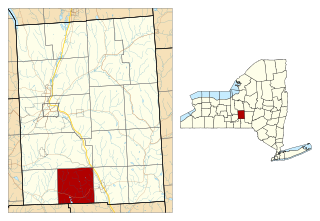
Lapeer is a town in Cortland County, New York, United States. The population was 767 at the 2010 census. Lapeer is on the south border of Cortland County and is south of the city of Cortland.
Truxton is a hamlet in Cortland County, New York, United States. The population was 1,133 at the 2010 census. The town is named for Commodore Thomas Truxtun, a privateer in the American Revolution and one of the US Navy's first commanding officers.
Homer is a town in Cortland County, New York, United States of America. The population was 6,405 at the 2010 census. The name is from the Greek poet Homer.

The Chenango River is a 90-mile-long (140 km) tributary of the Susquehanna River in central New York in the United States. It drains a dissected plateau area in upstate New York at the northern end of the Susquehanna watershed.

Chenango Forks is a hamlet located in Broome County, New York in the United States. The community is partly in the town of Chenango and partly in the town of Barker.
The Otselic River(aht-SEEL-ik), formerly known as Otselic Creek is a 55.4-mile-long (89.2 km) tributary of the Tioughnioga River in central New York in the United States. It drains a hilly area, mostly forested and agricultural, east of the Finger Lakes at the northern edge of the Susquehanna River watershed.
Otselic may refer to the following in the U.S. state of New York:
The Ladinian is a stage and age in the Middle Triassic series or epoch. It spans the time between 242 Ma and ~237 Ma. The Ladinian was preceded by the Anisian and succeeded by the Carnian.

The Boston Ten Townships refers to an area of 230,400 acres (932 km²) in Tioga County and Broome County, New York State,
between the Chenango River and Tioughnioga River and the west branch of Owego Creek, from the Susquehanna River about twenty-five miles northwards; it includes the northern half of the town of Owego and the towns of Newark Valley, Berkshire, and Richford in Tioga County, and a portion of the Broome County towns of Lisle, Nanticoke and Maine east of these. It is bounded on the west by the Watkins and Flint Purchase and a small portion of the original Chemung County, and on the north by the Central New York Military Tract. The boundary between Tioga County and Broome County is very irregular.

New York State Route 79 (NY 79) is an east–west state highway in the Southern Tier of New York, in the United States. The western terminus of the route is at the intersection with NY 414 near the southern end of Seneca Lake just northeast of Watkins Glen. Its eastern terminus is at the Pennsylvania state line in the town of Windsor in Broome County, where it connects to Pennsylvania Route 92 (PA 92). NY 79 passes through three regions; it starts in the Finger Lakes region, runs through Central New York and ends on the western fringes of the Catskills. The route is signed east–west, but from Whitney Point to the state line it runs in a north–south orientation and is signed north-south a few miles south of Center Village, a hamlet that is a few miles south of Harpursville.
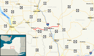
New York State Route 221 (NY 221) is a state highway in Cortland County, New York, in the United States. Its western terminus is at an intersection with NY 38 in the town of Harford. The eastern terminus is at a junction with NY 26 and NY 41 in the town of Willet. Near its western end, NY 221 intersects New York State Route 200. Together, NY 200 and NY 221 form a loop route off NY 38 between the hamlets of Harford and Harford Mills within the town of Harford. NY 221 originally followed modern NY 200 and ended at U.S. Route 11 (US 11) in Marathon when it was assigned as part of the 1930 renumbering of state highways in New York. It was extended to its present length by the following year and realigned to serve Harford later in the decade. NY 200 was assigned in the 1940s.

Saint-Bouize is a commune in the Cher department in central France.
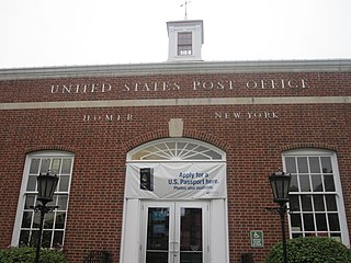
US Post Office-Homer is a historic post office building located at Homer in Cortland County, New York. It was built in 1937-1938 and is one of a number of post offices in New York State designed by the Office of the Supervising Architect of the Treasury Department, Louis A. Simon. It is a one-story, steel frame, five bay rectangular building clad in brick on a stucco clad foundation in the Colonial Revival style. The interior features a mural by Frank Romanelli in 1940 titled "Albany Street Bridge over Tioughnioga River." It is located within the boundaries of the Old Homer Village Historic District.

Water, Wall, and Pine Streets Lenticular Truss Bridges is a national historic district and set of Lenticular truss bridges located at Homer in Cortland County, New York. The district includes a series of three bridges built in 1881 over the Tioughnioga River by the Corrugated Metal Co. of East Berlin, Connecticut.
Blodgett Mills is a hamlet and census-designated place (CDP) in Cortland County, New York, United States. The population was 303 at the 2010 census. It is in the town of Cortlandville, southeast of the city of Cortland.
Killawog is a hamlet in Broome County, New York, United States. The community is located along the Tioughnioga River and U.S. Route 11 2.9 miles (4.7 km) south of Marathon. Killawog has a post office with ZIP code 13794.