Tlaltenango, Mexican toponym, may mean:
| This disambiguation page lists articles about distinct geographical locations with the same name. If an internal link led you here, you may wish to change the link to point directly to the intended article. |
Tlaltenango, Mexican toponym, may mean:
| This disambiguation page lists articles about distinct geographical locations with the same name. If an internal link led you here, you may wish to change the link to point directly to the intended article. |

Cuernavaca is the capital and largest city of the state of Morelos in Mexico. The city is located around a 90 min drive south of Mexico City using the Federal Highway 95D.
El Plateado de Joaquín Amaro or Joaquín Amaro, also known as El Plateado and as General Joaquín Amaro, is a municipality and community in Zacatecas, Mexico, located 105 km SW of Zacatecas City. It is bordered by the municipal divisions of Villanueva, Tabasco, Momax, and Tlaltenango de Sánchez Román.

Puebla International Airport, officially Hermanos Serdán International Airport is an international airport located in the municipalities of Tlaltenango, Huejotzingo and Juan C. Bonilla near Puebla, Puebla, Mexico. It handles national and international air traffic for the city of Puebla.

Atolinga is the seat of Atolinga Municipality in the Mexican state of Zacatecas, located in its southwestern portion.

The Caxcan were a partly nomadic indigenous people of Mexico. Under their leader, Tenamaztle, the Caxcan were allied with the Zacatecos against the Spaniards during the Mixtón Rebellion in 1540-42. During the rebellion, they were described as "the heart and the center of the Indian Rebellion". After the rebellion, they were a constant target of the Zacatecos and Guachichiles due to their ceasefire agreement with the Spaniards. Their principal religious and population centers were at Teul, Tlaltenango, Juchipila, and Teocaltiche.

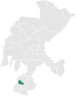
The city of Tlaltenangoo de Sánchez Román is located in the southwestern portion of the Mexican state of Zacatecas. The average elevation of the municipality is 1,723 meters (5,653 ft) above sea level and the municipality covers an area of 808.082 square kilometres (312.002 sq mi). The municipality lies in a valley bordered by the Sierra de Morones and lies on the banks of the Tlaltenango River, which runs north and is a tributary of the Bolaños River.
Miguel Caldera (1548–1597) was an important figure in the pacification and colonization of Mexico's northern frontier immediately following the Spanish conquest of the Aztec Empire.
The municipality of Tepechitlán is located in the southwestern portion of the Mexican state of Zacatecas. It is located between 21º33'49" and 21º44'00" latitude north and 103º09'07" and 103º32'01" longitude west with an average altitude of approximately 1700 meters above sea level. The municipality covers an area of 584 square kilometers.
The municipality and city of Huanusco is located in the southwestern portion of the Mexican state of Zacatecas.

Benito Juárez Municipality is a Mexican municipality located in the southern extreme of the state of Zacatecas on the edge of the Canyon of Tlaltenango.
Marcos Marcelo Escobedo (1784–1833) was a military commander in the Mexican War of Independence. He later became Mayor of Colotlán, Jalisco.
Mexico's Protected Natural Resource Areas are 6 federally recognized protected areas in Mexico that are administrated by the federal National Commission of Protected Natural Areas.

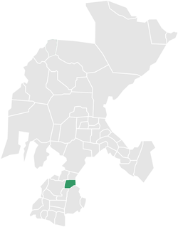
Atolinga is one of the 58 municipalities in the state of Zacatecas, Mexico. It is located on the southern part of the state of Zacatecas and is bordered by the municipalities of Tepechitlán and Florencia de Benito Juárez. To the east it is bordered by Tlaltenango de Sánchez Román and to the north and west by the state of Jalisco. The municipality covers a total surface area of 280 square kilometers (110 sq mi).

Teúl de González Ortega Municipality is a town and municipality located in the south of the Mexican state of Zacatecas, between the state capital of Zacatecas and the city of Guadalajara. Unlike most of the rest of the state, its economy has been based on agriculture and livestock, rather than mining, and it is noted for its production of agave and mezcal. The town has been named a Pueblo Mágico to promote a tourism industry.

The municipality of Colotlán is located in the northern extremity of the Mexican state of Jalisco. The municipality covers an area of approximately 505 square kilometers. Colotlán is located at 22°12′N103°18′W. It stands at 1,550 metres (5,090 ft) above sea level.

Zacatecas, officially the Free and Sovereign State of Zacatecas, is one of the 32 states of Mexico. It is divided into 58 municipalities and its capital city is Zacatecas City.
The following radio stations broadcast on FM frequency 90.1 MHz:
Tlaltenango (municipality) is a town and municipality in Puebla in south-eastern Mexico.
The following television stations broadcast on digital channel 25 in Mexico: