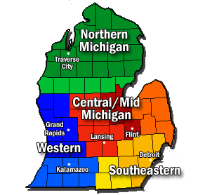
The Lower Peninsula of Michigan is the southern of the two major landmasses of the U.S. state of Michigan, the other being the Upper Peninsula. It is surrounded by water on all sides except its southern border, which it shares with Indiana and Ohio. Although the Upper Peninsula is commonly referred to as "the U.P." it is fairly uncommon for the Lower Peninsula to be called "the L.P."

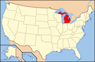
Michigan is a state in the Great Lakes and Midwestern regions of the United States. The state's name, Michigan, originates from the Ojibwe word mishigamaa, meaning "large water" or "large lake". With a population of about 10 million, Michigan is the tenth most populous of the 50 United States, with the 11th most extensive total area, and is the largest state by total area east of the Mississippi River. Its capital is Lansing, and its largest city is Detroit. Metro Detroit is among the nation's most populous and largest metropolitan economies.

The Upper Peninsula (UP), also known as Upper Michigan, is the northern of the two major peninsulas that make up the U.S. state of Michigan. The peninsula is bounded on the north by Lake Superior, on the east by the St. Marys River, and on the southeast by Lake Michigan and Lake Huron. Geographically, the Upper Peninsula has a land boundary with Wisconsin, and over-water boundaries with Minnesota and Ontario (Canada). Upper Peninsula counties also include nearby islands such as Grand, Drummond, Mackinac, and Bois Blanc, and more distant Isle Royale.

Ontonagon County is a county in the Upper Peninsula of the U.S. state of Michigan. As of the 2010 United States Census, the population was 6,780, making it Michigan's third-least populous county. The county seat is Ontonagon. The county was set off in 1843, and organized in 1848. Its territory had been organized as part of Chippewa and Mackinac counties. With increasing population in the area, more counties were organized. After Ontonagon was organized, it was split to create Gogebic County. It is also the westernmost U.S. county that uses the Eastern Time Zone.
Keweenaw County is a county in the Upper Peninsula of the U.S. state of Michigan, the state's northernmost county. As of the 2010 United States Census, the population was 2,156, making it Michigan's least populous county. It is also the state's largest county by total area, when the waters of Lake Superior are included in the total. The county seat is Eagle River.

Benzie County is a county in the U.S. state of Michigan. As of the 2010 census, the population was 17,525. The county seat is Beulah. The county was initially set off in 1863 and organized in 1869.

The Niagara Escarpment is a long escarpment, or cuesta, in the United States and Canada that runs predominantly east/west from New York, through Ontario, Michigan, Wisconsin, and Illinois. The escarpment is most famous as the cliff over which the Niagara River plunges at Niagara Falls, for which it is named.
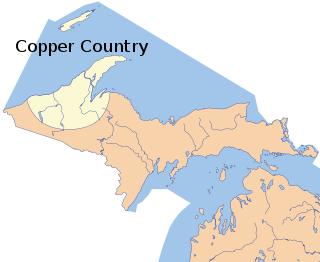
The Copper Country is an area in the Upper Peninsula of Michigan in the United States, including all of Keweenaw County, Michigan and most of Houghton, Baraga and Ontonagon counties as well as part of Marquette County. The area is so named as copper mining was prevalent there from 1845 until the late 1960s, with one mine continuing through 1995. In its heyday, the area was the world's greatest producer of copper.

The Middle Peninsula is the second of three large peninsulas on the western shore of Chesapeake Bay in Virginia, in the United States. It lies between the Northern Neck and the Virginia Peninsula. This peninsula is bounded by the Rappahannock River on the north and the York River on the south, with the Chesapeake Bay to the east. It encompasses six Virginia counties: Essex, Gloucester, King and Queen, King William, Mathews, and Middlesex. Developed for tobacco plantations in the colonial era, in the 21st century the Middle Peninsula is known for its quiet rural life, vegetable truck-farming, and fishing industry.

The Territory of Michigan was an organized incorporated territory of the United States that existed from June 30, 1805, until January 26, 1837, when the final extent of the territory was admitted to the Union as the State of Michigan. Detroit was the territorial capital.
The following is an alphabetical list of articles related to the U.S. state of Michigan.

The Eagle River Light is a decommissioned lighthouse at the mouth of the Eagle River in the community of Eagle River on the Keweenaw Peninsula in the U.S. state of Michigan.

The White River Light is a lighthouse on Lake Michigan near the city of Whitehall, Michigan. It sits on a thin peninsula of land separating Lake Michigan from White Lake. The building was built in 1875.

Michigan's 1st congressional district is a United States Congressional district containing the entire Upper Peninsula of Michigan and 16 counties of Northern Michigan in the Lower Peninsula. The district is represented by Republican Jack Bergman.

The Tittabawassee River is a stream that flows in a generally southeasterly direction through the Lower Peninsula of the U.S. state of Michigan. The river begins at Secord Lake in Clement Township, at the confluence of the East Branch and the Middle Branch. From there it flows through Gladwin, Midland and Saginaw counties where, as a major tributary of the Saginaw River, it flows into it at Saginaw. Its tributaries include the Chippewa, Pine, Molasses, Sugar, and Tobacco rivers.

Michigan consists of two peninsulas that lie between east longitude, and are separated by the Straits of Mackinac, and some nearby islands. With the exception of two small areas that are drained by the Mississippi River by way of the Wisconsin River in the Upper Peninsula and by way of the Kankakee-Illinois River in the Lower Peninsula, Michigan is drained by the Great Lakes-St. Lawrence watershed and is the only state with the majority of its land thus drained.
The following outline provides an overview of and topical guide to the U.S. state of Michigan: