
The Au Sable River in Michigan, United States runs approximately 138 miles (222 km) through the northern Lower Peninsula, through the towns of Grayling and Mio, and enters Lake Huron at Au Sable. It is considered one of the best brown trout fisheries east of the Rockies and has been designated a blue ribbon trout stream by the Michigan Department of Natural Resources. In French, au sable literally means "at the sand." A 1795 map calls it the Beauais River.

The Stillwater River is a 69.3-mile-long (111.5 km) tributary of the Great Miami River in western Ohio in the United States. Via the Great Miami and Ohio rivers, it is part of the Mississippi River watershed.
Edenville is a small unincorporated community in Edenville Township, Midland County in the U.S. state of Michigan.
The Belle River is a 73.5-mile-long (118.3 km) river in the U.S. state of Michigan, flowing into the St. Clair River in Marine City at 42°42′25″N82°29′50″W.
Sweetwater Creek is a 45.6-mile-long (73.4 km) stream in the U.S. state of Georgia, west of Atlanta. It begins in southwestern Paulding County, flowing generally eastward into southwestern Cobb County, then turning south into eastern Douglas County. It is a tributary of the Chattahoochee River, and near its end it is the centerpiece of Sweetwater Creek State Park.

Pine River may refer to any of the following streams in the U.S. state of Michigan:
- Pine River. The main branch forms with the confluence of the East and West Branches of the Pine River at 44°29′38″N83°23′16″W in Alcona County. The South Branch joins approximately 1.5 miles (2.4 km) to the south and flows into Iosco County, where it empties into Van Etten Lake at 44°29′38″N83°23′16″W northwest of Oscoda.
- Pine River. The main branch is formed by the confluence of the North and Middle Branches northeast of Standish and flows into the Saginaw Bay of Lake Huron at 43°58′32″N83°51′16″W. The South Branch Pine River joins the main stream at 43°59′08″N83°53′17″W.
- Pine River is a short waterway, which along with Round Lake, connects Lake Charlevoix with Lake Michigan at Charlevoix.
- Pine River rises in Chippewa County and flows south through Mackinac County into the St. Martin Bay of Lake Huron at 46°03′09″N84°39′22″W The North Pine River, also known as the North Branch Pine River, joins at 46°12′20″N84°36′17″W. Another tributary, Hemlock Creek, is also known as Pine River.
- Pine River, also known as the South Branch Manistee River, rises in southeast Wexford County, flows southwest across northwest Osceola County, then west and north through the northeast corner of Lake County and back into southwest Wexford County, emptying into the Tippy Dam Pond on the Manistee River at 44°13′37″N85°54′27″W. The main stream is formed from the confluence of the East Branch Pine River with the North Branch Pine River at 44°06′02″N85°31′40″W. Another tributary, the Spaulding Creek, is also known as the Little Pine River
- Pine River, in Marquette County, is a very short stream draining Pine Lake into Lake Superior at 46°53′27″N87°52′13″W, north of the Huron Mountains.
- Pine River rises in from Pine Lake in eastern Mecosta County, flows mostly south and east through Isabella County, then south along eastern edge of Montcalm County, then east and north through Gratiot County and Midland County, emptying into the Chippewa River at 43°36′06″N84°17′33″W, just about two miles before it joins the Tittabawassee River near Midland. The South Branch Pine River joins the main stream at 43°30′37″N85°00′02″W Another tributary, Miller Creek, is also sometimes known as Pine River or the West Branch Pine River. The North Branch Pine River joins the main stream at 43°26′03″N84°50′18″W.
- Pine River empties into the St. Clair River at 42°49′13″N82°29′08″W on the south side of St. Clair. The South Branch Pine River joins the main stream at 42°58′11″N82°37′10″W. Another tributary, Quakenbush Drain, is also sometimes known as Pine River.
- Pine Creek empties into Lake Superior and is also known as the Pine River.

The Cass River is a 61.5-mile-long (99.0 km) river in the Thumb region of the U.S. state of Michigan. It drains large portions of Sanilac and Tuscola counties and smaller portions of Genesee, Huron, Lapeer, and Saginaw counties.

The Cedar River is a 29.0-mile-long (46.7 km) river in the U.S. state of Michigan, flowing through Clare County and Gladwin County.
Salt River is the name of two streams in the U.S. state of Michigan.
Coldwater River is a 13.1-mile-long (21.1 km) stream in the U.S. state of Michigan. Located in Isabella County, the river rises as the outflow of Littlefield Lake in western Gilmore Township. The river flows mostly south and empties into the Chippewa River at 43°37′22.231″N84°57′38.243″W on the western boundary of Deerfield Township, about two miles east of Lake Isabella.
The White River is a 60.1-mile-long (96.7 km) river in the U.S. state of Vermont. It is a tributary of the Connecticut River.
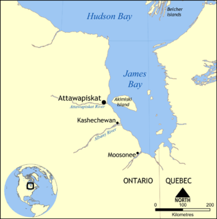
The Attawapiskat River is a river in Kenora District in northwestern Ontario, Canada, that flows east from Attawapiskat Lake to James Bay.
The Kawkawlin River is a 17.5-mile-long (28.2 km) stream in the U.S. state of Michigan that flows into Saginaw Bay of Lake Huron at 43°39′30″N83°53′00″W, approximately 1 mile (1.6 km) west of the mouth of the Saginaw River.
The South Branch Little Sugar River is an 11.5-mile-long (18.5 km) river in Gladwin County, Michigan. It is a tributary of the Sugar River, which flows via the Tittabawassee River to the Saginaw River.

The Saganing River, also known as Saganing Creek, is a 10.0-mile-long (16.1 km) stream in the U.S. state of Michigan.
The Passadumkeag River is a river in Maine. From the confluence of its East Branch and West Branch in Maine Township 3, Range 1, NBPP, the river runs 48.2 miles (77.6 km) south and west to its mouth on the Penobscot River in Passadumkeag.
The West Branch Mattawamkeag River is a 52.6-mile-long (84.7 km) tributary of the Mattawamkeag River in Maine. From its source in Maine Township 6, Range 6, WELS, the river runs 10 miles (16 km) northeast by Pleasant Lake and through Mud Lake and Rockabema Lake, then 42 miles (68 km) south and southeast through Upper Mattawamkeag Lake and Mattawamkeag Lake to its confluence with the East Branch Mattawamkeag River in Haynesville, about 10 miles (16 km) west of the Canada–United States border.
The Little Black River is a 6.1-mile-long (9.8 km) stream in Cheboygan County in the U.S. state of Michigan. It rises in Beaugrand Township at 45°40′28″N84°35′48″W and flows eastward into Lake Huron in the city of Cheboygan at 45°39′47″N84°29′21″W, less than a mile west of the mouth of the Cheboygan River.
Little Cedar River is an 8.1-mile-long (13.0 km) river in Gladwin County in the U.S. state of Michigan.
Walnut Creek is a 30-mile-long (48 km) tributary of the South River in the U.S. state of Georgia. It originates in the city of Hampton in Henry County and flows into South River, which is a branch of the Ocmulgee River.


