
Yangon is the capital of the Yangon Region and the largest city of Myanmar. Yangon served as the capital of Myanmar until 2006, when the military government relocated the administrative functions to the purpose-built capital city of Naypyidaw in north central Myanmar. With over seven million people, Yangon is Myanmar's most populous city and its most important commercial centre.

Chin State is a state in western Myanmar. Chin State is bordered by Sagaing Division and Magway Division to the east, Rakhine State to the south, the Chittagong Division of Bangladesh to the west, and the Indian states of Mizoram to the west and Manipur to the north. The population of Chin State is about 478,801 according to the 2014 census. The capital of the state is Hakha. The state is a mountainous region with few transportation links. Chin State is sparsely populated and remains one of the least developed areas of the country. Chin State has the highest poverty rate of 73% as per the released figures from the first official survey. The official radio broadcasting dialect of Chin is Falam. There are 53 different subtribes and languages in Chin State. There are nine townships in Chin State: Hakha, Thantlang, Falam, Tedim, Tonzang, Matupi, Mindat, Kanpetlet and Paletwa townships. In 1896, Mindat and Kanpetlet were placed under Pakokku Hill Tracts District of British Burma later emerged into Chin Hills. Only Paletwa Township became a part of Arakan Hill Tracts of British Burma.
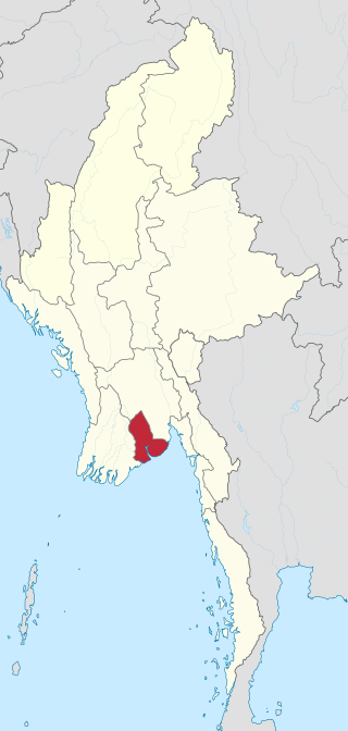
Yangon Region(Burmese: ရန်ကုန်တိုင်းဒေသကြီး; MLCTS: rankun tuing desa. kri:, pronounced[jàɰ̃ɡòʊɰ̃táɪɰ̃dèθa̰dʑí]; formerly Rangoon Division and Yangon Division) is an administrative region of Myanmar. Located in central Myanmar, the division is bordered by Bago Region to the north and east, the Gulf of Martaban to the south, and Ayeyarwady Region to the west. Yangon Region is dominated by its capital city of Yangon, the former national capital and the largest city in the country. Other important cities are Thanlyin and Twante. The division is the most developed region of the country and the main international gateway. The division measures 10,170 km2 (3,930 sq mi).
North Okkalapa Township is located in the eastern part of Yangon. The township comprises 19 wards, and shares borders with Hlegu Township and Mingaladon township in the north, North Dagon Township in the east, Mingaladon Township and Mayangon Township in the west, and Kamayut Township, and Mayangon and South Okkalapa Townships in the south. North Okkalapa was one of the satellite towns established in 1959. Today, it is a firmly established part of the city, albeit with nominal access to the city's electricity grid and sewer system. It is located in the 5 to 30 minute drive zone to Yangon International Airport, the primary and busiest international airport of Myanmar, located in Mingaladon Township. For those who loves local trips, Aung Mingalar Highway Bus Station is located within 30 min drive zone from the township.
Lawksawk, also known as Yatsauk, is a town in Shan State, Myanmar. It is the capital town and administrative center of Lawksawk Township. The town is located along an oxbow lake of the Zawgyi River at an altitude of 910 metres (2,990 ft). Lawksawk is about 48 kilometres (30 mi) north of Taunggyi, or 70 kilometres (43 mi) by road on National Route 43. It was the historical capital of Lawksawk State. The town is near Bahtoo Station, a major military base.
Hlegu Township is a မြို့နယ် of Yangon Burma, Burma (Myanmar). It is northeast of the city Yangon and is largely rural.

Dagon University, located in North Dagon, Yangon, is one of the largest universities in Myanmar. The university, established in 1993, offers bachelor's and master's degrees in liberal arts and sciences to full-time, part-time and online students. Dagon University also offers a full-time four-year law degree program. The university's 1,582-acre (6.40 km2) campus in the outskirts of Yangon is one of the largest campuses in the country.

Dagon Township is located immediately north of downtown Yangon. The township comprises five wards, and shares borders with Bahan Township in the north, Ahlon Township in the west, Mingala Taungnyunt Township in the east, and Lanmadaw Township, Latha Township and Pabedan Township in the south.
Dagon Seikkan Township is an urban township of Yangon, Myanmar.
East Dagon Township is located in the easternmost part of Yangon, Myanmar. The township comprises 54 wards and three village tracts. It shares borders with Hlegu Township in the north, North Dagon Township in the west, and South Dagon Township in the south and west. One of new satellite towns founded in 1989 by the military government that came to power in 1988, East Dagon is still largely undeveloped and lacks basic municipal services.
North Dagon Township is located in the eastern part of Yangon, Myanmar. The township comprises 25 wards, and shares borders with East Dagon Township in the north and east, South Okkalapa township in the west, and South Dagon township in the south. North Dagon is a relatively more developed area among the new satellite towns founded in 1989 by the military government. The realestate price is also considered highest among other new satellite townships.
South Dagon Township is located in the southeastern part of Yangon, Myanmar. The township comprises 26 wards and three village tracts, and shares borders with North Dagon Township and East Dagon Township in the north, Thingangyun Township in the west across the Pazundaung Creek, the Bago River in the east, and Dagon Seikkan Township in the south. South Dagon is one of the new satellite towns founded in 1989 by the military government.
Shwepyitha Township is located in the northwestern part of Yangon, Myanmar. The township comprises 27 wards and 3 village tracts, and shares borders with Htantabin Township to the north, Mingaladon Township to the east, the Yangon river to the west, and Insein Township to the south. Incorporated into the city of Yangon in 1986, Shwepyitha is now developing and has basic municipal services. Improvements include tidy and broad main roads and many streets form a grid. Hlaing River separates Shwepyithar and Hlaingtharyar. Shwepyithar Bridge was built in 1996 and now it is a useful bridge in Yangon and is also the start of the Yangon-Pathein-Chaungthar Highway. Htan Chuak Pin Junction is regarded as the centre of Shwepyithar and many well known places are there. Shwepyithar Advanced Theatre (3D) was opened in March 2017. There are many gyms and shops around its centre. At night, the street-market of Htan Chauk Pin offers dining. Ruby Market is the most famous market. Bogyoke Aungsan Road, Bayint Naung Road, No.4 Highway, etc. are the most popular roads in the town. The Yangon Circular Railway passes through the township. Its railway station is also at the Yangon-Pyay-Mandalay Railway. Many Language Centres teach English, Korean, Japanese and Chinese. Many advanced restaurants and hotels as well as motels are there. Many job opportunities can be available in Shwepyithar because it has the Shwepyithar Industrial Zone, Warr Ta Ya Industrial Zone and Thardukan Industrial Zone.Dagon Beverage Company Limited also exists there. Shwe Pyi Thar is an up-and-coming Yangon township.

Mingala Taungnyunt Township is a township of Yangon, Myanmar. Located in the east-central part of the city, the township consists of 20 wards, and shares borders with Dagon Township in the west, Bahan township in the north, Botataung Township in the south, Kyauktada Township in the southwest, and the Pazundaung Creek and Dawbon Township in the east.

Kalay, also known as Kale, is a town in the Sagaing Region of Myanmar. It is located upstream from Mandalay and Monywa on the Myittha River, a tributary of the Chindwin River. The town is the district headquarters of the Kalay District. It has gained importance with trans border movement enabled between Myanmar and India following the 165 kilometres (103 mi) Tamu–Kalay section of India–Myanmar–Thailand Trilateral Highway built by the Border Roads Organization of India under the Look-East Connectivity policy. Consequently, Kalay is now one of the fastest developing towns in Myanmar.

Yangon Central railway station, also known as Yangon Central Station, is the largest railway station in Myanmar. It is located within downtown Yangon, and serves as the gateway to Myanmar Railways' 3,126 mi (5,031 km) rail network whose reach covers Upper Myanmar, upcountry (Myitkyina), Shan hills, and the Taninthayi coast.
The Daai are an ethnic group living in Chin State, Myanmar. The Daai consist of 32 Chin tribes, which have been registered by the Government of Burma since 1890. The recent Military Regime’s census mentions the Daai tribe as the 62nd of 135 tribes of Burma. Researchers refer to them as the Daai group in the ethnic survey book of Burma. The Daai Chin appear to be of Mongolian, Indo-Chinese, and Tibeto-Burman descent. The Daai people live in the Mindat, Paletwa, Matupi and Kanpetlet townships of Southern Chin State in Burma. There are more than 180 Daai villages with a total population of somewhere between 40,000 and 50,000. Their population makes the Daai-Chin the majority tribe of the Southern Chin Hills.

Rail transport in Myanmar consists of a 6,207.644 km (3,857 mi) railway network with 960 stations. The network, generally spanning north to south with branch lines to the east and west, is the second largest in Southeast Asia, and includes the Yangon Circular Railway which serves as a commuter railway for Yangon, the principal commercial city in Myanmar. The quality of the railway infrastructure is generally poor. The tracks are in poor condition, and are not passable during the monsoon season. The speed of freight trains is heavily restricted on all existing links as a consequence of poor track and bridge conditions. The maximum speed for freight trains has been quoted as 24 km/h (15 mph), suggesting that commercial speeds on this section could be as low as 12–14 km/h (7.5–8.7 mph).
Thayettaw is a complex of over 60 Buddhist monasteries (kyaung) in Yangon, Myanmar, located in Lanmadaw Township's 9th ward, immediately north of Yangon Chinatown. The monastery occupies a sprawling plot that is bounded by Bogyoke Aung San Road to the north, Anawrahta Road to the south, Phongyi Street to the west, and Myoma School Street to the west.