The Amu Darya ,(Persian: آمو دریا) also shortened to Amu and historically known as the Oxus, is a major river in Central Asia, which flows through Tajikistan, Turkmenistan, Uzbekistan and Afghanistan. Rising in the Pamir Mountains, north of the Hindu Kush, the Amu Darya is formed by the confluence of the Vakhsh and Panj rivers, in the Tigrovaya Balka Nature Reserve on the border between Afghanistan and Tajikistan, and flows from there north-westwards into the southern remnants of the Aral Sea. In its upper course, the river forms part of Afghanistan's northern border with Tajikistan, Uzbekistan, and Turkmenistan. In ancient history, the river was regarded as the boundary of Greater Iran with Turan, which roughly corresponded to present-day Central Asia. The Amu Darya has a flow of about 70 cubic kilometres per year on average.

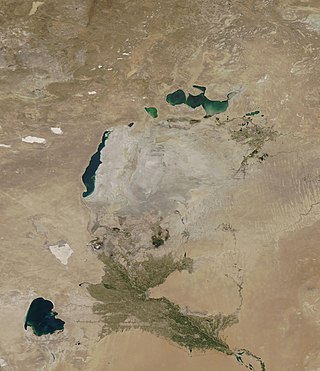
The Aral Sea was an endorheic lake lying between Kazakhstan to its north and Uzbekistan to its south, which began shrinking in the 1960s and had largely dried up by the 2010s. It was in the Aktobe and Kyzylorda regions of Kazakhstan and the Karakalpakstan autonomous region of Uzbekistan. The name roughly translates from Mongolic and Turkic languages to "Sea of Islands", a reference to the large number of islands that once dotted its waters. The Aral Sea drainage basin encompasses Uzbekistan and parts of Afghanistan, Iran, Kazakhstan, Kyrgyzstan, Tajikistan, and Turkmenistan.

The Syr DaryaSEER-DAR-yə, historically known as the Jaxartes, is a river in Central Asia. The name, which is Persian, literally means Syr Sea or Syr River. It originates in the Tian Shan Mountains in Kyrgyzstan and eastern Uzbekistan and flows for 2,256.25 kilometres (1,401.97 mi) west and north-west through Uzbekistan, Sughd province of Tajikistan, and southern Kazakhstan to the northern remnants of the Aral Sea. It is the northern and eastern of the two main rivers in the endorheic basin of the Aral Sea, the other being the Amu Darya.

The Karakum Desert, also spelt Qaraqum and Garagum, is a desert in Central Asia. The name refers to the shale-rich sand beneath the surface. It occupies about 70 percent, or roughly 350,000 km2 (140,000 sq mi), of Turkmenistan.

Pyotr Fyodorovich Anjou was an Arctic explorer and an admiral of the Imperial Russian Navy.

The Ustyurt or Ust-Yurt is a transboundary clay desert shared by Kazakhstan, Turkmenistan, and Uzbekistan.
The Aralkum Desert is a desert that has appeared since 1960 on the seabed once occupied by the Aral Sea. It lies to the south and east of what remains of the Eastern Basin Aral Sea in Uzbekistan and Kazakhstan. It is currently the youngest desert in the world.

Moynaq, also spelled as Muynak, is a city in northern Karakalpakstan, an autonomous republic in Uzbekistan. It is the seat of the Moynaq district. Formerly a sea port on the Aral Sea, it is now 150 km from the water in the Aralkum Desert and thus is a disaster tourism destination. It is also the location for the biggest electronic music festival in Central Asia.

Aral, also known as Aralsk or Aral'sk, is a small city in south-western Kazakhstan, located in the oblast (region) of Kyzylorda. It serves as the administrative center of Aral District. Aral was formerly a fishing port and harbour city on the banks of the Aral Sea, and was a major supplier of fish to the neighboring region. Population: 29,987 ; 30,347.

The North Aral Sea is the portion of the former Aral Sea that is fed by the Syr Darya River. It split from the South Aral Sea in 1987–1988 as water levels dropped due to river diversion for agriculture.

Vozrozhdeniya Island was an island in the Aral Sea. The former island's territory is split between Uzbekistan and Kazakhstan. In 1954, the Soviet Union constructed a biological weapons test site called Aralsk-7 there and on the neighbouring Komsomolskiy Island, which also no longer exists.

The Caspian Depression or the Caspian Lowland is a low-lying flatland region encompassing the northern part of the Caspian Sea, the largest enclosed body of water on Earth. It is the larger northern part of the wider Aral-Caspian Depression around the Aral and Caspian Seas.
Kazakhstan, has serious environmental issues such as radiation from nuclear testing sites, the shrinking of the Aral sea, and desertification of former agricultural land. These issues are due in large part to Kazakhstan's years under the Soviet Union.

Qyzylorda Region, formerly known as Kyzyl-Orda Region until 1991, is a region of Kazakhstan. Its capital is the city of Qyzylorda, with a population of 234,736. The region itself has a population of 823,251. Other notable settlements include Aral, Kazaly (Kazalinsk) and the Russian-administered Baikonur, which services the Baikonur Cosmodrome. The total area of the province is 226,000 square kilometers (87,000 sq mi).

Aral is a district of Kyzylorda Region in southern Kazakhstan. The administrative center of the district is the town of Aral. Population: 74,689 ; 70,562 ; 68,382.

The South Aral Sea was a lake in the basin of the former Aral Sea which formed in 1987 when that body divided in two, due to diversion of river inflow for agriculture. In 2003, the South Aral Sea itself split into eastern and western basins, the Eastern Sea and the West Aral Sea, connected by a narrow channel that balanced surface levels but did not allow mixing, and in 2005 the North Aral Sea was dammed to prevent the collapse of its fisheries, cutting off the only remaining inflow to the southern lakes. In 2008, the Eastern Sea split again, and in May 2009 had almost completely dried out, leaving only the small permanent Barsakelmes Lake between the Northern and Western Seas and increasing the expanse of the Aralkum desert. In 2010, it was partially filled again by meltwater, and by 2014 was once again dry. The West Aral Sea has some replenishment from groundwater in the northwest.

The Main Turkmen Canal was a large-scale irrigation project in the Turkmen Soviet Socialist Republic. The canal was intended to transport water from the Amu Darya river to Krasnovodsk, a city in Turkmenistan on the coast of the Caspian Sea. The canal was going to use the course of the ancient dry Uzboy River bed.
The Moklenic or Moken–Moklen languages consist of a pair of two closely related but distinct languages, namely Moken and Moklen. Larish (1999) establishes the two languages as forming two distinct subgroups of a larger Moken–Moklen branch. Larish (2005) suggests Moklenic as an alternative name for Moken–Moklen, the latter term which was originally used by Larish (1999).

The Barsuki Desert is a desert zone in the Aktobe and Kyzylorda regions of Kazakhstan. It has two parts, the Greater Barsuki in the west and the Lesser Barsuki in the east. They are elongated strips of sand desert parallel to each other and separated by a roughly 65 kilometers (40 mi) wide stretch of non-desert terrain.