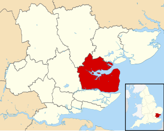
Maldon is a local government district in Essex, England. Its council is based in the town of Maldon, and the next largest centre of population is Burnham-on-Crouch. The district covers the Dengie peninsula as well as an area to the north of the Blackwater Estuary, a total area of 358.78 km².

Burnham Ramblers Football Club is a football club based in Burnham-on-Crouch, Essex, England. They are currently members of the Eastern Counties League Division One South and play at Leslie Fields.

Heybridge Swifts Football Club is a football club based in Heybridge, near Maldon, Essex, England. They are currently members of the Isthmian League North Division and play at Scraley Road.

Witham is a parliamentary constituency represented by Priti Patel, who served as the Secretary of State for International Development between 14 July 2016 and 8 November 2017, in the House of Commons of the Parliament of the United Kingdom.
The Kelvedon and Tollesbury Light Railway was an 8-mile-42-chain (13.72 km) light railway in Essex, England. It was authorised under the Light Railways Act 1896 and operated between the two villages of Kelvedon and Tollesbury to the south of Colchester. The line, which was part of the Great Eastern Railway (GER), was authorised on 29 January 1901, although its opening was delayed until 1 October 1904.

Tolleshunt D'Arcy is a village and civil parish in the county of Essex in the East of England. The parish has a parish council, and lies within the area of Maldon District Council.

Tolleshunt Major is a small village approximately five miles north east of Maldon, in the Maldon District of Essex, England. It forms part of the electoral ward of Tolleshunt D'Arcy and is situated on the northern bank of the River Blackwater.
Sandling is a suburb to the north of the town of Maidstone, Kent, England. Within the area is the headquarters of the Kent Wildlife Trust at Tyland Barn. Beside the River Medway is an eating place called The Malta Inn. Sandling is also home to the Museum of Kent Life. Sandling is also home to Lower Grange Farm, a new activity centre, owned and currently being developed by Kent Scouts.
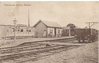
Tolleshunt d'Arcy railway station was on the Kelvedon and Tollesbury Light Railway, serving the village of Tolleshunt d'Arcy, Essex. The station was 6 miles 52 chains (10.70 km) from Kelvedon station.
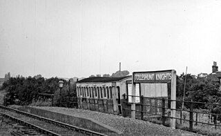
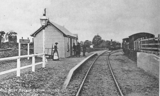
Tolleshunt Knights railway station was on the Kelvedon and Tollesbury Light Railway, serving the village of Tolleshunt Knights, Essex. The station was 4 miles 1 chain (6.46 km) from Kelvedon station.

Tenterden St. Michael's was a railway station on the Kent and East Sussex Railway which served the Tenterden suburb of St Michaels in Kent, England. The station was situated on the southern side of a level crossing to the south of St. Michael's tunnel, one of the line's main civil engineering features. Closed in 1954, nothing remains of St. Michael's today: a footpath and cycleway runs through the site.
Easthorpe is a small village in the Colchester District, in the English county of Essex in the East of England. Easthorpe is on an old Roman road. Nearby settlements include the large town of Colchester and the villages of Marks Tey, Copford and Copford Green. The main A12 road and Marks Tey railway station are nearby.

Wanborough Grange refers to an existing late medieval barn and formerly its surrounding monastic grange in Wanborough, Surrey, England.
Woodlands Redoubt, also known as one of the two Twydall Redoubts, was constructed in 1888. It was not included in the original list of defensive structures proposed by the Royal Commission on the Defence of the United Kingdom in 1860, but was conceived later and implemented as an experimental redoubt as opposed to a more substantial fort.
Grange Redoubt, also known as one of the two Twydall Redoubts, was constructed in 1885. It was not included in the original list of defensive structures proposed by the Royal Commission on the Defence of the United Kingdom in 1860, but was conceived later and implemented as an experimental redoubt as opposed to a more substantial fort.

The Queen's Head is a public house at The Square, Tolleshunt D'Arcy, Essex CM9 8TF.
Tiptree Parish Field is a 2.2 hectare Local Nature Reserve in Tiptree in Essex. It is owned and managed by Tiptree Parish Council.
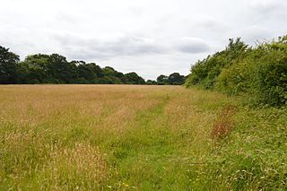
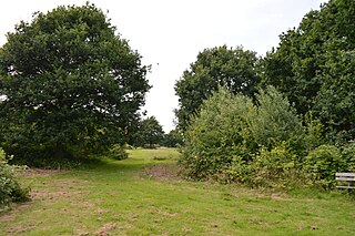
Oxley Meadow is a 3.2 hectare nature reserve in Tolleshunt Knights, near Tiptree in Essex. It is managed by the Essex Wildlife Trust.

The Queens Head is a public house in the village of Sandridge to the north of St Albans, Hertfordshire, England.


