
Kansas is a U.S. state in the Midwestern United States. Its capital is Topeka and its largest city is Wichita, with its most populated county being Johnson County. Kansas is bordered by Nebraska on the north; Missouri on the east; Oklahoma on the south; and Colorado on the west. Kansas is named after the Kansa Native American tribe, which inhabited the area. The tribe's name is often said to mean "people of the (south) wind" although this was probably not the term's original meaning. For thousands of years, what is now Kansas was home to numerous and diverse Native American tribes. Tribes in the eastern part of the state generally lived in villages along the river valleys. Tribes in the western part of the state were semi-nomadic and hunted large herds of bison.

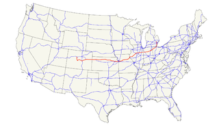
Interstate 70 (I-70) is a major east–west Interstate Highway in the United States that runs from I-15 near Cove Fort, Utah, to I-695 near Baltimore, Maryland. I-70 approximately traces the path of U.S. Route 40 east of the Rocky Mountains. West of the Rockies, the route of I-70 was derived from multiple sources. The Interstate runs through or near many major cities, including Denver, Kansas City, St. Louis, Indianapolis, Columbus, Pittsburgh, and Baltimore.

Shawnee County is a county located in northeast Kansas, in the central United States of America. As of the 2010 census, the population was 177,934 making it the third-most populous county in Kansas. Its most populous city, Topeka, is the state capital and county seat. The county was one of the original 33 counties created by the first territorial legislature in 1855, and it was named for the Shawnee tribe of Native Americans.

The Kansas River, also known as the Kaw, is a river in northeastern Kansas in the United States. It is the southwestern-most part of the Missouri River drainage, which is in turn the northwestern-most portion of the extensive Mississippi River drainage. Its two names both come from the Kanza (Kaw) people who once inhabited the area; Kansas was one of the anglicizations of the French transcription Cansez of the original kką:ze. The city of Kansas City, Missouri, was named for the river, as was later the state of Kansas.
The Kansas Turnpike is a 236-mile-long (380 km), freeway-standard toll road that lies entirely within the U.S. state of Kansas. It runs in a general southwest–northeast direction from the Oklahoma border to Kansas City. It passes through several major Kansas cities, including Wichita, Topeka, and Lawrence. The turnpike is owned and maintained by the Kansas Turnpike Authority (KTA), which is headquartered in Wichita.
U.S. Route 24 is one of the original United States highways of 1926. It originally ran from Pontiac, Michigan, in the east to Kansas City, Missouri, in the west. Today, the highway's northern terminus is in Independence Township, Michigan, at an intersection with I-75 and its western terminus is near Minturn, Colorado at an intersection with I-70. The highway transitions from north–south to east–west signage in Toledo, Ohio.
Westgate Bridge may refer to:
The Heart of America Bridge is a vehicular girder bridge over the Missouri River, in Kansas City, Missouri. It carries Route 9. It was the vehicular replacement for the upper level of the ASB Bridge, and runs next to it a few hundred yards downstream. It was opened in 1987.

The Bob Kerrey Pedestrian Bridge is a 3,000-foot (910 m) footbridge across the Missouri River between Council Bluffs, Iowa, and Omaha, Nebraska. It opened on September 28, 2008.
In the U.S. state of Kansas, Interstate 70 contains the first segment to start being paved and to be completed in the Interstate Highway System. It extends from the Colorado border near the town of Kanorado to the Missouri border in Kansas City. The route covers 424 miles (682 km) and passes through several of the state's principal cities in the process including Kansas City, Topeka, and Salina. The route also passes through the cities of Lawrence, Junction City, and Abilene.

KTOP is a radio station serving the Topeka, Kansas metropolitan area. The station currently broadcasts a sports talk format, but prior to October 4, 2007, had broadcast an adult standards/oldies format. KTOP is owned by Cumulus Media and licensed to Cumulus Licensing LLC.

The Pencoyd Railroad Bridge is a former railroad bridge in Kansas City, Missouri, that was converted into the Freight House Pedestrian Bridge and moved to its new location where it connects Union Station and the Crossroads Arts District.

The Intercity Viaduct is an automobile and pedestrian crossing of the Kansas River in the United States. Designed by Waddell and Hedrick, this four lane, two level deck truss bridge was built in 1907. It rises above the West Bottoms, and several sets of railroad tracks. It was the first roadway bridge to connect Kansas City, Missouri, with Kansas City, Kansas, non-stop all the way across. It is about 1.5 miles (2.4 km) long and carries eastbound traffic for Interstate 70 (I-70)/U.S. Route 24 (US 24)/US 40/US 169, while its sister bridge, the Lewis and Clark Viaduct, built in 1962, carries westbound traffic.
The Oakland Expressway Bridge is an automobile crossing of the Kansas River at Topeka, Kansas.
It is open to traffic, and also carries K-4 as well. The bridge used drilled shaft construction technology when built in 1996.
The Sardou Bridge is an automobile crossing of the Kansas River at Topeka, Kansas.
The North Kansas Avenue Bridge is a four lane, automobile and pedestrian crossing of the Kansas River at Topeka, Kansas, U.S.A. The bridge connects downtown Topeka to North Topeka. It is open to traffic.
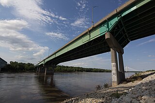
The Westgate Bridge is a four-lane automobile crossing of the Kansas River at Topeka, Kansas, U.S.A. The bridge runs concurrent with U.S. Highway 75. The bridge extends from Interstate 70 across the river to NW 17th Street.
The Willard Bridge is an automobile crossing of the Kansas River at Willard, Kansas. The bridge was constructed by Frisbie Bridge Company of Topeka, Kansas, and opened in 1955 and rehabilitated in 1983. The bridge was demolished in October 2017 and rebuilt in August 2017.

Clements is an unincorporated community in Chase County, Kansas, United States.
